

SoundSummiter
-
Posts
23 -
Joined
-
Last visited
SoundSummiter's Achievements
")
Gumby (1/14)
0
Reputation
-
 We decided to do the traverse N-S mostly because we were inspired by Blake's TR from 2006. After doing it I would recommend going this way because the final traverse might be hard to get onto if one had to rappel to it. Also, climbing those pitches really make the route IMO.
 -
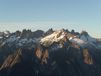
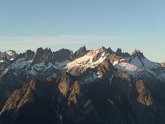
We headed out on Friday night to avoid the ridiculously early get up needed to catch the Saturday LOTL Express from Field's Point. After looking for a bit we stopped and slept in the gravelly parking lot of the Entiat Museum, which may be the best roadside bivy I've had. The next morning we grabbed a gas station breakfast and hopped on the boat up Lake Chelan. When we got to Stehekin we grabbed some boxed wine and huckleberry licorice and caught the next bus up to High Bridge, stopping at the Stehekin bakery to grab cinnamon rolls. Shortly after noon:45 we were finally on our way down the PCT toward Swamp Creek. The PCT was a pleasant appetizer to the horror that would soon unfold. At 4pm we stopped at Swamp Creek camp and took a break. We still had a lot of day light so we talked about heading up the drainage as far as we could before calling it a day. On the ferry we ran into Josh H (who was going after Devore) and got a bit of beta on the approach. He recommended going up to the basin at about 4400' and bivying in the grass there. So with 5 hours of daylight we headed up Swamp Creek. We were able to follow the abandoned trail for about 30-40 minutes before the alder closed in and strangled all hope of a moderate approach. What followed was the most intense BW5 jungle warfare of our Cascade climbing lives. The brush was so thick at times that not ever light could get through it. We persisted; making two sketchy creek crossings, one of which required Dustin to pioneer a bold, acrobatic, alder scramble. We finally emerged from the jungle a little before 9pm, and made a mediocre camp in the basin under the headwall. Even though we had not started the climb yet we all pretty much agreed that we were now committed, because we were not going to go back down Swamp Creek. We got a lazy start the next morning and headed up the left side of the headwall as is well documented in online beta. There was a pretty well established climbers trail up and around the waterfall, and we were in the 5000' basin before too long. We took a break and filled as much water as we could before we left the lower elevations for the next day and a half. The Dark Glacier was really chill, with only a couple of 40-45 degree sections. About half way up we took a break on some rocks before the final push to the summit. Dustin had been carrying a sticky bun from the bakery and accidentally left it here. Some more step-kicking followed and we topped out on the glacier, getting our first look at Bonanza - it looked far away. We un-roped and did the final scramble up to the summit of Dark Peak and took in the views. Although the position was great, just how Dark Peak is considered its own principal summit is beyond me. Not only is it just one of many marginally prominent bumps on the long northern ridge of Bonanza, but it's not the tallest either. Jim at the summit of Dark Peak. After coming back down from the summit we went over to take a look at the beginning of the traverse. We still had a few hours of daylight and considered trying to get to the saddle between Pt. 8599 and the West summit of Bonanza before bivying, but in the end decided to wait for tomorrow. This was a good decision. We spent the rest of the evening building bivy spots with wind walls to protect us from the building icy wind from the west. As the evening wore on the clouds began to build until we were completely enveloped. The hopes of the traverse were a little precarious, but it was too soon to call. We awoke to clear skies on July 3rd, but the icy wind that had persisted through the night was still beating us down. Dustin's bag actually had ice on it. This caused us to be a little sluggish on getting going, starting the traverse with the heavy puffies on. We headed out soloing the ridge. The terrain was a mix of 3rd and 4th class with ample exposure. We moved from the ridge proper to either side of the ridge; up, down, and around towers. We felt like we were making good time, but could see that some of the biggest gaps in the ridge were still ahead. Somewhere near the middle of the traverse to the saddle below the west peak we encountered the first section that caused us to rope up. We simuled for a couple pitches in a stunning position with Jim leading the way. The ridge eased as we neared Pt. 8599 and we put the rope away. Up to this point we thought that once we got to Pt. 8599 we would be onto easy class 2/3 boulders, but we were pleasantly surprised to see some involved ridge scrambling ahead. At one point we came to an airy section that we roped up for again. Two more simul pitches and we were finally on the easy northern slopes of the west peak. We took a lunch break and looked at the final ridge above. It didn't look terrible. The final jaunt up to the west summit was easy moving and went quick. When we topped out we found a summit cairn with an old tin can register. According to this register we were only the sixth summit party on the west peak, and the first since 2011. This was pretty surprising, and rewarding, considering how often Bonanza gets climbed. Our attention was quickly re-directed to the final ridge ahead of us since it was getting late in the day. This final portion was only about 1/3 the distance of the ridge we had just done, but was a bit more involved. The first simul pitch was relatively straight forward, consisting of undulating moves over a small tower. The second simul pitch started with a class 4+ vertical section that eased off to a knife edge before descending steeply back to the final notch. We stayed on the north side of the ridge, wedging our bodies in the tiny moat which vacillated between icy and calf-high post holes. Without this moat the route would have required a bit more cavalier approach. From here the route traversed along a bare wall with a small ledge running across it to twin cracks. Dustin took the lead and disappeared around the corner. The rope moved relatively well at first, but then slowed. We heard lots of blocks trundle down the 2000' face to the Company Glacier, but thought nothing of it. Trundling is just part of a ridge traverse. As the rope went taught I moved out onto the face to follow. Dustin was now at the base of the vertical bit, and I could see just how sparse the traverse really was. After a couple minutes of studying the route Dustin floated up some of the most memorable 5.pucker climbing any of us had ever had. He built a belay and brought us up. One final simul pitch, which included another somewhat memorable move, and we were at the summit, victorious. It had taken us 12 hours to reach the summit from Dark Peak. We enjoyed the summit for a brief moment before starting our descent. We took our time, since none of us had climbed the Mary Green route before. Two rappels down low brought us to the bergschrund where we roped up and stepped onto the glacier just before dark. We followed the glacier down by headlamp until coming to a small ledge with trees above the waterfall slabs. Not wanting to downclimb the slabs in the dark we decided to bivy there for the night. We cooked up some food and tried to get comfortable. After a short sleep we were up and moving. We scouted our descent and made a single free-rappel down a waterfall to some slabs next to the snow. From here it was easy walking down to Holden pass. We dropped our gear and had breakfast. Looking up towards Martin peak it seemed unlikely that the route was only class 3 with some 4th class up high. At around 10:30am we started moving towards the west ridge of Martin. Dropping onto the south side we started ascending loose gullies; the kind that any true connoisseur of choss just can't get enough of. Down low the route-finding was pretty easy and we made good progress. As we got higher the route turned in to a maze of marginal gullies that pushed the pucker-factor. The final 15 feet were probably the most solid of the climb, and definitely 4th class. We topped out around 3pm, completing the Dark-Bonanza-Martin traverse. The views from Martin were stunning. Our route followed the skyline from right to left. Bonanza is quite the beast, and being able to see our whole route from Dark was exhausting. After we had had our fill of the view we reversed our route and returned to our gear at Holden pass. From here we moved camp down to Holden Lake where we fought off mosquitos and deer throughout the night. On July 5th we packed up and headed out to Holden Village where we grabbed some breakfast and caught the bus down to Lucerne. The ride out was uneventful.
-
There is a huge bivy ledge about 3/4 of the way up the buttress. When we climbed (July 26/27) there was some snow just around the corner from the bivy ledge, but not much. I don't remember seeing too much snow around the route besides that. I would recommend carrying any water that you think you will need.
-
What did you guys climb in? Do you think trail runners would have been fine? We climbed in mountaineering boots. I have a pair of Scarpa Charmoz. The 5th class climbing is pretty easy because the rock is pretty sticky.
-
Great write up Luke! I think you adroitly documented our adventure. Anyone using the 5200' bivy will be in debt of Nips' hard mining work to even out a pesky rock. [img:small]https://lh4.googleusercontent.com/-APJYqFpgQI0/U9Zfsfpf4wI/AAAAAAAAGfw/z_A5RmDNs38/w811-h608-no/SAM_2628.JPG[/img] This was definitely one of the best trips to be had in the Cascades, even after dealing with the vampire Bushy-tailed Woodrats and stubborn Black Bears.
-
That's a lot more snow than when I did this route, interesting. Nice work on the C2C push. We did it in two days because we heard that the bivy on the ridge was spectacular - confirmed! Great pictures.
-
[TR] Canyonlands - Towers 5/1/2013
SoundSummiter replied to dberdinka's topic in The rest of the US and International.
Fantastic climbs and pictures! We spent 3 days in Indian Creek this past weekend as well. Truly an amazing place with never-ending lines! -
[TR] Snowfield Peak - North Face / West Ridge 3/31/2013
SoundSummiter replied to SoundSummiter's topic in North Cascades
After seeing the lines up there we felt the same way Josh. Luckily we left a couple bumps up there to tag during a future ski tour. -
Trip: Snowfield Peak - North Face / West Ridge Date: 3/31/2013 Trip Report: After having to turn back in January because of poor planning around the shorter winter days, Nate R., Luke S. and myself headed out to NCNP to take another swipe at Snowfield Peak. The forecast was for another gorgeous weekend in the mid- to upper-60’s, uncommon for March. To ensure success this time we went out to the trail head on Friday night to bivy and get a good early start on Saturday morning. The parking pull-off was snow-free this time so we had a comfortable night with gorgeous stars. At 5 am the alarm went off and we readied ourselves for the approach to camp. Although not terribly far as the crow flies we would gain 5700’ and have to cross lots of soft snow to get there. The trail was snow free for a while and when we got to snow it was firm which made quick progress. We topped the ridge at about 10:30 am, donned snowshoes, and traversed the ridge to the 5800’ notch at 11:30 am. Ascending the ridge at about 5400' The warm weather meant we needed to assess this traverse for avy conditions. There was evidence of some pockets falling from the face, but the slope and cornices above, were quite stable. We moved quickly under the face and arrived at the toe of the Colonial Glacier which felt like stepping into an oven. We roped up and Nate led us out across the glacier and up to the col. At 1 pm we strolled in with legs feeling a bit rubbery. Being that it was still so early I floated the idea of going for the summit that afternoon, but after discussing it with the group we decided to rest and take advantage of the early morning crust. We melted snow and re-hydrated then took about a 3-hour nap – it was delicious. The view over to the Nevé Glacier and Snowfield were again magnificent. I was glad to be out here again to enjoy one of the most spectacular glaciers in the North Cascades. The winding S’s of ski turns left by a team that had completed the Isolation Traverse a week prior were inspiring too. The summit pyramid was all crusted up with ice so we knew things could get interesting up there, but that was for tomorrow. At about 5:30 pm we moved up on the hillside and had dinner. As the sun set the colors and views became more impressive. We moved up the side of Pt. 7505 so we could see the horizon and watched the sun set just to the south of Mt. Baker. It was an incredibly clear, warm, and calm night – especially for March. We descended back to camp, slipped into our bags, and BS-ed for a while before turning in for the 4 am wake up. At 4 am the moon cast a silver path right along our intended route across the Nevé. The climb was on so we geared up, tied in, and were off just before 5 am. At just after 6 am the sun began to warm the eastern horizon and the moon’s light became obsolete. As we approached the summit pyramid we could see the slope up the northern side wasn’t nearly as steep as it had looked from camp. We decided to take a line on the right side of the face toward a gully that led straight to a notch in the west ridge. The snow was in great step-kicking shape and Nate once again led us up the 40-50 degree slope that took us to the notch. Looking back down, the glacier looked like a satin tablecloth, while all the peaks of the North Cascades were capped with the golden rays of the new day. Route up on the right, and down on the left. Turning back to the ridge ahead of us we were faced with boulders covered in a 12 inch layer of rime ice. What is normally a 3rd class scramble would be a little more interesting for us. The first bit was rambley and Nate led up it without a problem. He belayed Luke and I up to a ledge where the terrain got a bit steeper and a bit more crusted up. I took this lead, which looked tougher than it was, and in about 30 feet I was standing on the summit ridge. I belayed the others up and we all walked over to the true summit where we took in the views and marveled at the serrated snow-capped skyline. It was now about 7:45 am. Summit shot 1. Summit shot 2. The wind started to blow a little so we decided to move out. Instead of following the same route down we dropped straight off the summit onto the north face and down-climbed back to the glacier. Overall the face was pretty moderate, but there was a short bit just below the summit that was 60+ degrees. As we worked our way down the wind brought continuous spindrift down the slope on us. This didn’t make it difficult, but definitely added to the alpine aspect. About halfway down we turned out and plunge-stepped the rest of the way to the glacier before heading back to camp. Again we were treated to fantastic views all around as we descended the Nevé. Descending the Nevé. The slope back up to camp was grueling, but we made it at just about 9 am. We ate, drank, and broke camp before donning our heavy packs for the death march. It was really starting to warm up so we knew time was of the essence. Once at the bottom of the Colonial Glacier we were again in a parabolic oven. As we strolled past the frozen waterfalls a small chunk busted off and sunk into the soft snow beneath it. We could see the main portion of the pillar had a large fracture line near the top and remarked on how it would be cool to see it let go. Not two minutes later this 30 foot pillar did just that with a booming crack. This too, harmlessly slid to a halt, but it was pretty impressive to see and gave us good reason to get to the traverse and out of avalanche terrain. The traverse went without issue, but the snow had definitely gotten softer and wetter so it was nice to be off it. From here on it was a rapid descent from the ridge to the basin and to the trail head. We stumbled to the car at 2 pm to close out a satisfying 9 hour day, topped off with double bacon cheeseburgers in Marblemount. Approach Notes: Early season conditions allow an ascending traverse up the hillside to the crest of the ridge leading to Pyramid Peak. We descended this way and it saved us some milage. Not sure if it would be a good option after everything melts out and the brush springs up.
-
Hard to top these photos. Thanks for the awesome stoke!
-
Arc'teryx & Patagonia / Tele & Climbing Gear
SoundSummiter replied to Kodiak1234's topic in The Yard Sale
PM sent on Gri Gri -
PM on all screws and cams.
-
[TR] Sloan Peak - West Face Variation 7/8/2012
SoundSummiter replied to BootsandPants's topic in North Cascades
I remember that we descended those ledges on the south east side by a series of gullies. They were a bit wet even in August. This part of the trip probably took the most route finding. We had to do a double rope rap to get off the last one - just barely got us over the moat. Nice work on getting the climb in with less than perfect conditions! -
Trip: Primus & Austera - Date: 7/6/2012 Trip Report: Justin and I headed out to Cascade River Rd to head up to the Inspiration Ice Cap on the first day of a gorgeous weather window for the North Cascades. Our plan was to try and hit Primus, Austera, Klawatti, and perhaps Dorado Needle in three days. It was a steep bill. On Wednesday we picked up our permit and hit the trail at about 0830. The log crossing was easy to find and the trail / boulders were mostly snow free up to about 5k feet. While in the second boulder field we encountered some marmots engaged in hand-to-hand combat. Each on it’s hind legs with the fore knocking around the other. This was a bit comical to watch until another, larger, marmot showed up and bitch-slapped one of the former before chasing it down the slope and out of sight. It was also at about this time that we started to emerge from the morning clouds that had kept us reasonably cool through the first couple thousand feet. J-berg looked pretty rad with the clouds framing it and its massive hanging glacier. Marmot MMA J-Berg We crossed the rib over into the Rouche Basin and headed up the final slopes to the Inspiration glacier. The sun was now fully out and it was warming up quick. We stopped at the crest to have lunch and rope up. It was about 1pm. We were heading to Klawatti col to make camp and could see that we would be breaking trail most of the way. There was another party doing Eldorado and we followed their steps as long as possible. After their path broke from ours we began to weave our way through the Inspiration glacier. The glacier was still pretty filled in which made route finding easy, but there was a good layer of unconsolidated snow that made breaking trail slow going. Constant post-holing and wallowing through snow that was sometimes knee-deep got us to Klawatti col at about 1645. We set up camp and started to get familiar with our surroundings. Around 1715 a ranger showed up. I didn’t think that we would encounter a ranger this far out, but being that he had been part of the party on Eldo, he figured he come make sure we had a permit. After chatting with him for a bit we got to bed at a reasonable hour to prepare for the next day. We got up at 0530 and were moving by 0630 for our first destination of the day: Primus peak. It’s a long slog to Primus, although not technical, and the views along the way are fantastic. The first obstacle is to cross the Klawatti-Austera col, which can be either a 4th or 5th class problem later in the season, but turned out to be an easy snow crossing for us. Once across the col we skirted along the Klawatti glacier staying high enough to avoid crevasses, but not gaining any unneeded elevation. Across the valley was Forbidden with Boston and Buckner rising on its flanks. To the north stands the mass of Mount Logan and the sheer western profile of Goode. Once near the Austera ridge we descended to ~7200 feet and rounded the toe of the ridge. Here we got our first good views of Primus and could see we still had a ways to go. From here it is just a descent on the North Klawatti glacier and then up an easy slope. We arrived at the summit at 0945, ate some food, and took in the great views. Primus isn’t much of a climb, but the vantage is outstanding. We sat naming peaks for a while before heading down and making our way back to the Klawatti glacier. Klawatti-Austera Col Primus Summit shot 1 Primus Summit shot 2 The way back was a little easier with the steps to walk in, but the hot sun was melting them out quick. Once back around the toe of the Austera ridge we started following it until we ran into the south slopes of the false summit. We scrambled up to the ridgeline and got our first view of the summit tower. The chockstone gulley was still completely snow filled so we took the 4th class option to the right. This went easily and led to a bit of snow above the chockstone gulley before the final step up to the summit block, it was now 1330. Again the views were awesome. The main highlight here is the view down over the McAllister icefalls. We kept hearing things break off, but rarely could see any of it. After a half hour on the summit we descended and began the trudge back to camp. We arrived back at camp just before 1600, threw down the rope and pack and took an hour nap on the warm rocks. Around 1700 we walked over to take a look at the south face of Klawatti, but backed off due to avy debris and the warm sun still baking the face. We discussed giving it a try in the morning, but ended up leaving it for another day. McAllister Icefalls It was a bit of a bummer to have to leave Klawatti, but I will be happy to have to return to this place to bag it. The hike out was pretty uneventful. We had not seen anyone really on Wednesday on our way up, but ran in to multiple parties on the way down. Gear Notes: Standard Glacier gear. Approach Notes: Glacier is still pretty filled it, but melting fast. We saw multiple cracks opening up in our path on the way back.
-
Trip: Koke'e State Park - Nu'alolo Canyon Trail Date: 4/24/2012 Trip Report: On Tuesday morning Emily and I got a semi-early start and began the drive out to the western side of Kaua’i, past Waimea Canyon, and to Koke’e state park. The road lazily meanders up to 3600 feet, taking enough hairpin turns to make even a strong-stomached person gasp. The whole drive dark clouds mustered around the sentinel peaks of the interior, threatening to wash out our plans. However, having hiked in the NW for years I know not to throw in the towel until the skies open. Parking at the visitor center we walked a couple hundred yards south to the Nu’alolo TH. About ¾ mile to the north commences the Awa’awapuhi trail, each running out about four miles to stunning vistas. Our plan was to take the former, continue on to the 2.2 mile Cliff Trail that skirts along a ledge on crumbling layers of ancient volcanic expulsions that drops roughly 2000 feet into deep green caverns, and then onto the latter back to the road. Including the trek back along the road to the visitor center the entire loop comes to about 11 miles. If doing the loop it is recommended to follow the direction we did due to the difference in grade between the two trails. We hit the trail at 9:30am, and after ascending a couple hundred feet, began our 1400 foot descent to the littoral precipitous canyons. The trail starts with thick forest before opening up to meadows allowing the first views over the adjacent ridgelines which look nothing more than rolling hills. The trail is wide and easy to follow, but as you approach the ridge that escorts you to the first vistas of the day the terrain rapidly steepens to down-climbing a slippery clay-like slope. This descent is made easier by the abundance of exposed roots from years of erosion caused by the trail becoming the main drainage for the route. Although not difficult it is easy to see why you would rather descend this trail than climb it after 7 miles in the humid mountain air. In an hour and change we came to the end of the timberline on the ridge and began to take in 300 degree views of the canyons and coastline. The declivitous canyon walls seemed to be incapable of holding anything save deep green vegetation that seemed to be painted on in long horizontal strokes that forsook the generations of volcanic construction. The sharp drops allowed vertigo-inducing looks down to the gullet of the serrated gashes. Only along the very bottom was the grade easy enough to allow trees, which resembled a lighter green river in the otherwise emerald landscape. As a complement, reddish-orange soil frosted the tops of the ridges and was again revealed at the mouth of the river as it spilled into the aquamarine waters below. The impervious nature of this coastline lends it to popular helicopter tours, several of which slithered in and out of the canyons below us, looking like nothing more than birds. After a brief snack we continued on to the Cliff Trail which took us near some steep drops on marginal rock/dirt which may have been dicey on a rainy day. The trail weaved back into a nook of the canyons before bringing us out to the other vista point. Again the views were spectacular. Despite our concerns the weather had held, and the clouds remained high. At times a cool mist would fill the air, giving a refreshing reprieve from the warm air. This vista has a navigable ridge traverse that situates one surrounded by long drops on either side. A walk that can be airy, but is definitely worthwhile. Satisfied with the spoils of our work we began the long, 1500 foot, uphill trudge back from the canyon walls. Although the grade is easy, it seems to go on forever, only to take you to an undulating road back to your car. We had only begun to make this final leg of the loop when we were fortuitously picked up by a couple we had met the previous day. It was now about 1:30 pm. The trail is a definite highlight for any trip to the Garden Island. Gear Notes: Plenty of water.