DougBrownVancouver
-
Posts
10 -
Joined
-
Last visited
DougBrownVancouver's Achievements
")


-
Trip: Lions, Howe Sound, BC - Lions NE Ridge Date: 10/15/2013 Trip Report: A pretty good scramble for climbers? Fairley Guide (Climbing and Hiking in SW BC, 1994) calls the route 5.3 and less than aesthetic (due to bush in parts), however I had a great time and thoroughly enjoyed it (3y/o and 7 month old at home.....didn't get out climbing all summer....had a partial day of freedom from Vancouver and was giddy to be out and on some good rock). I wore trail runners and brought a small rappel rope in case I wanted to bail. Generally good rock quality, the lower section before the shoulder had the steeper and more exposed climbing (5.3 seems fair, no more that 1-2 moves of 5th class in a row with significant exposure, spotted 2 old rusty pins). I found the lower part of the route exciting because you can't see very far ahead and I was constantly thinking that if this gets any harder I'm not going to be happy soloing....but every time I would step up or move around a corner, it would ease up enough to keep me going. The upper section above the shoulder is less steep and easier but there is an obvious gendarme that kind of looms over you as a potential stopper........when I got to it, I thought briefly about taking it straight on (?5.8ish leading to ??? out of sight), but then bailed left into some steep gully trees (looked kind of gross but turned out to be reasonable travelling...coastal classic?). The ridge tops out right at the cairn for the tourist route which makes for a nice descent. Probably not a good route for the non-climber scrambling crowd (lots of opportunities to take a big fall if you made bad choices) and probably not a great 'climbing' route since it would probably be hard to get great flow with the rope, trees, & often changing steepness......but a pretty darn fun scramble, up an aesthetic 1200 ft ridge, that is very close to the city. From the top of the logging road: ~3hrs up, ~2hrs down. First ascent was in 1913 and was a solo by Basil Darling (I am not worthy.....) Lower part of the route and the mid height shoulder (seen from the west on the approach) Skyline is the mid height shoulder and upper part of the route (seen from the west on the approach) Looking up from the base of the route (Fairly Guide shows route starting out of sight to the right on better rock....probably the better start but my head wasn't into steep rock yet so I started from the treed ledge) Looking up while on the steep lower part of the route Upper part of the route as seen from the mid height shoulder. Foreshortened upper gendarme as seen from the route (can avoid it at the last moment by going left into steep trees that look bad but turn out to be fine) Peek-a-Boo view of Vancouver near the summit of the NE Ridge Gear Notes: I used trail runners and had a 30m rappel rope and some tat in my bag that I didn't use but gave me the piece of mind to keep climbing on the lower section. Approach Notes: Lions (Binkert) Trail to the ridge at 1250m (N49 27.428 W123 11.599) then traverse NE across good talus to the obvious notch at the base of the west ridge (about N49 27.555 W123 11.347). Descend about 60m in a NNE facing gulley (loose) and then traverse west to the base of the route.
-
Trip: Crown Mountain, The Camel - Widow Maker Arete Date: 8/31/2009 Trip Report: The first time we climbed this route it was in a complete white out, we accidentally skipped the first 4 pitches and climbed it in the path of least resistance mode (since we couldn't see anything) and had very few moves of 5.9 climbing. This time it was a beautiful day, we managed to find the start of the route and managed to find several short sections of nice sustained 5.8, 5.9 climbing. At the final headwall we explored right instead of left and climbed what we assume is a nice variation of the route described in Alpine Select. The right hand side of the final headwall has some stunning steep cracks (there is an off-width to chimney size left facing split pillar that we didn't climb but looks amazing). Having done no research we called our previously climbed and probably previously named variation "Where's Widow." Dru will probably be able to give us the actual name of route given by the first ascentionists. First 2 Pitches Top of Pitch 1 5.8 Step Approaching the 1st Headwall 2nd and Final (Crux) Headwall Bottom part of Final Headwall P1 of Where's Widow Variation Camel Summit Crown Summit Gear Notes: Alpine Rack, 60m rope. Approach Notes: Climb the grouse grind and traverse to Crown Pass then drop into Hanes Valley and traverse to the base of the route or climb up the Hanes Valley trail from the Lynn Headwaters Park (see Alpine Select approach notes).
-
A friend at the ACC told me the CD ROMs should be available at Christmas, so hold on just a little while longer! I also got a hold of the 1987 CAJ article and it sounds like the Serl/Fowraker route was quite a bit harder "True North" IV 5.10 A3 and not really recommended. Based on the story I'm guessing they took the right hand side of the North Butress / Prow feature up to the same rappel point where they joined the original route (as opposed to the more left hand route followed by the Driscoll/Fairley route & pictured in the post above). It was however a pretty good story and if Don felt like reposting it it might help flesh out the history of the area to the internet generation.
-
I haven't seen the '87 CAJ Serl/Fowerake route description. I've heard rumors that the old CAJs are now online somewhere but I did a quick scan of their site and couldn't find any links to the old journals, do you know how to get access. WRT the north buttress of Macabre do you know where someone might have written that route up, the length/position/exposure look like it might be really good if the rock was sound. Thanks Drew.
-
Trip: Cathedral Park BC - Grimface North Buttress (Driscoll/Fairley) Date: 8/2/2008 Trip Report: Quoting From the Fairley Guide, [brackets are my notes]: “North Buttress: FA: R. Driscoll, B. Fairley- June 30, 1985. This is the longest and most difficult route on Grimface [as of 1985, I’m guessing someone has put up harder lines by now]. Ascend snow on the left side of the toe of the buttress and begin in a short, obvious crack which leads to a sloping ramp [my 1st belay]. Move straight up from the end of the ramp (5.9 crack) and gain a hand crack at the west end of a ledge. Follow the crack making a couple of hard moves where it trends left [i kept looking left but then climbing mostly straight up here with small moves to the right, my 2nd belay], then climb a crack and blocks to gain a ledge. A large wall with moss-filled ctacks shoots upward from this ledge, but instead of climbing these, the route traverses left, down a few moves [my 3rd belay], then ascends a cleaner 5.9 crack to a roof. Undercling the roof to the right and step around onto a smooth wall [my 4th belay in an alcove with a slightly friable white wall], following a strenuous 5.10 crack to an arête [still 5.9 climbing assuming we were on route]. The sixth pitch [my 5th] then follows a curving crack and traverses right below overhangs. Some class 4 gains the notch, where a short rappel is necessary. Above the notch, traverse out to the right of the buttress crest. If you get lost en route, some hard variations are no doubt possible. Excellent rock; 11 pitches [8 pitches for us, we had 60m ropes but never stretched them out fully], with most climbing in the 5.7 to 5.9 range. Recommended.” Descent: Easy walk off to the NW following cairns, then we dropped back into the basin at the base of the route to retrieve some stashed gear but I imagine it would be easy to keep hiking NW and then pick up the trail back to Ladyslipper lake. Pretty good rock, nice climbing, wonderful setting. The wildflowers in the park in early August are worth the visit even without the climbing. First Pitch Route from Goat Lake Approach Amazing looking North West Face/Buttress of Macabre Tower that might yield a Liberty Crack quality route if someone hasn't put one up already. Gear Notes: 50 or 60m rope. Alpine rack (we brought a slightly larger rack than normal with a set of nuts and a single set of cams to #4 camelot, probably didn't need the #4 but was nice to have an extra larger piece once and a while). Approach Notes: Cathedral Provincial Park: Location Map http://www.env.gov.bc.ca/bcparks/explore/regional_maps/southok.html Park Map: http://www.env.gov.bc.ca/bcparks/explore/parkpgs/cathedral/cathedral.pdf Approach: ~14km hike in via the Lakeview trail 4-5hrs with full packs or 3-4hrs if you hike the logging road instead (bit shorter, much less scenic) or ~$120 to get the lodge folks to drive you up their “private” logging road in their Unimog (literally highway robbery). Camp at Quinscoe, Pyramid or other spot. Hike the goat lake trail and turn west into the drainage below Grimface at about 6700ft before you get to Goat lake.
-
A Call to Arms: The Stawamus / Indian FSR
DougBrownVancouver replied to Mr_Sleazy's topic in British Columbia/Canada
Thanks for setting this up. I also emailed as per the post and added the following personal statement. I first climbed Sky Pilot in 1992 after driving all the way to the end of the spur road. Since that time I have climbed in that area approximately every other year with constantly decreasing access. Both historically and recreationally this area is very important. I find it hard to believe that Squamish is trying to position itself as the recreation capital of Canada and is at the same time closing access to the closest and some of the best almost alpine granite in the area (Haybrich is a real gem). If cost is part of the equation limiting access please advertise that fact to the outdoor community because I think that people may be willing to step up to the fundraising plate to ensure access to such an important recreation area. Doug Brown. -
Looking North From Pelion Rumbling Gl. Great Ridge Scrambling More Great Scrambling Tantalus Summit Bivy on the shoulder of Dione Topping out on Serratus Bivy on Serratus Serratus never ends Alpha Summit (S**t eating grin) Cable Crossing Cheers, Doug
-
Trip: Tantalus Range - Tantalus High Traverse Date: 8/12/2006 Trip Report: This report describes a high traverse of the Tantalus Range starting with a hike up Sigurd creek, ascents of Pelion, Tantalus, Dione, Serratus, and Alpha, followed by a descent to the Squamish River, cable crossing and mountain bike back to the truck. Four long days to lake lovely water and one easy day out, it was a wonderful mountaineering adventure. August 12, 2006. Day 1: Sigurd Creek and Pelion. We stashed a mountain bike at the spur road leading to the cable car crossing of the Squamish river. We then drove to the Sigurd creek trail head. We hiked up the Sigurd creek trail, traversed around east side of prominent 2200m tower at the end of the NE ridge, passed through the col at ~grid:745,240, traversed and climbed the north side glacier and an easy rock scramble to the summit. Descended south ridge until SW glacier could be reached. Descended and traversed on west side of the mountain until possible to easily rejoin the Squamish-Clowhom divide at approximately 2000m elevation. After a couple of foiled attempts, descended from the bump at ~755,225 by contouring on the south side approximately 50-100m below the summit then dropped steeply. Great bivy with water about 20 minutes before the Zenith col ~761,219. 13.5hrs from the truck. Day 2: Tantalus. Hiked to the Zenith col, got stuck on the ridge at ~765,213, doubled back and traversed on the east side of the ridge and onto the Rumbling glacier. Ascended snow, then easy rock, then steep snow, then a bit more rock to the notch in the ridge at ~761,201 (potential large and very large moats during all transitions from rock to snow provided multiple cruxes throughout the trip). Great scrambling along the north ridge of Tantalus with occasional forays onto the west side snow staying on the ridge crest the entire way until it abutted the head of the Rumbling glacier ~762,187. Very short flat glacier crossing followed by some broken 5th class rock led to a high steep snow/ice field. Kicked steps up good snow, crossed one very short section of ice, rejoined the rock, easy scrambling to a notch where the southeast spur route intersects, more easy scrambling to the summit (14 years after my first trip into Lake Lovely Water and 8 Tantalus Range trips later I am finally on the summit of the big T….yahoo). Descended near the ridge crest of the south east spur until possible to rappel into the ‘Darling’ couloir (see Alpine Select), descent below this point looked poor possibly due to a lack of snow, instead a 5th class rising traverse was made to the Dione-Witch’s tooth col followed by an exposed traverse onto the snow below Dione. Dione was temporarily bypassed in favor of a great bivy on the ridge crest ~767,181 (no free water but lots of snow). 14hrs. Day 3: Dione and Serratus. Started the day (backpack free) with a quick climb of the SE face of Dione. Back to the bivy spot, then great scrambling down the Dione ridge until ~773,171, left the rock to save a bit of time descending the snow to the Serratus, Dione col and lunch in the shiny new Jim Haberl hut. A combination of a known party high in the Serratus west face couloir, some cloud obscuring the route and the general unattractiveness of the line, made us opt for the south gully that climbs from the Serratus-Ionia col. This turned out to be the most uncomfortable section of the trip due to the very steep snow, a lack of snow protection and a sketchy bridge across a mid height schrund. An exit right onto the rock was made at the first opportunity followed by easy 3rd class scrambling to the summit. About 20 minutes of easy scrambling brought us to another fabulous bivy on the ridge crest ~784,157 (no water, down climbed to collect snow). 12hrs. Day 4: Serratus East Ridge, Alpha and Lake Lovely Water. Descending the east ridge of Serratus was the mental crux of the trip. It is a compact series of ongoing towers and obstacles, the route finding is difficult when traveling west to east and it is difficult to get any flow to your movement unless you are comfortable free soloing exposed 4th class terrain (we moved almost continuously, mostly simul-climbed, left 2 slings as ‘top-rope’ pieces for the second, made 3 rappels and bypassed the last 2 towers on steep north facing snow and it still took over 9hrs from the summit to the Alpha-Serratus col, less than 1.5km on the map!!). Climbed easy snow on the north side of Alpha to rejoin the west ridge at ~798,157 followed by easy scrambling to the summit. A glorious descent down the 3rd class scrambling of the east ridge followed by 2 rappels ended the technical rock section of the trip. A bit of easy glacier travel gave way to the steep heather and tree descent down to Lake Lovely Water. 14hrs. The trip had been planned as a four day affair but the time spent on the east ridge of Serratus stymied our quest for burgers and beer that night. Instead we opted for the welcome faces in the alpine club hut and were treated to a sumptuous chili diner by some generous climbers who work for a local rafting company. Day 5: Lake Lovely Water Trail, Cable Crossing & Bicycle Ride. After a lovely sleep at the alpine club Hilton, the hike down the lake lovely water trail to the Squamish river was superb, the new trail routing along the river to the cable car was a welcome change from the old bush route through the logging slash and crossing the cable was exciting as always. A sunny bike ride along the Squamish Valley road was the perfect finale to a grand loop of a magical mountain range. Gear Notes: 50m 9mm Rope, Alpine Rack, Ice Axes, Crampons, 2 Ice Screws (a picket or two would have been nice).
-
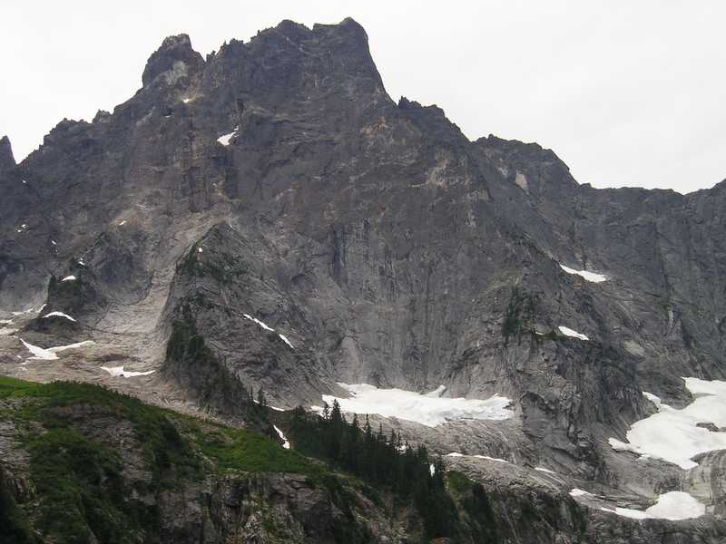
July 22, 2006. Glaciers were very actively calving and three large ice avalanches were noted during the pre-dawn and dawn approach (a section of the toe of the Bi-Pass and two smaller glaciers to the south let go). Traveling on the bi-pass (well back from the active edge) was good in approach shoes with ice axes and aluminum crampons until we were within 200m of the route. At this point multiple hidden seracs were encountered. A path to the base of the route looked possible without any particularly technical climbing, however it would involve traveling below vertical sections of seracs and blocks with considerable hazard (we choose to retreat). The route will likely be in similar shape until the blocks and seracs crumble back, cooler weather allows night-time freezing or the whole thing blasts off for the valley.
-
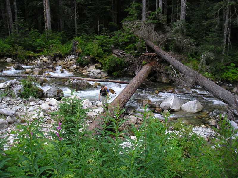
New (2006) Sleese Trail Beta, do not take the right hand spur just before the gate as per Alpine Select unless you want to wade across the creek and bushwack on the old road for 15-30minutes before hitting the buff trail. For the new trail, walk 5-10 minutes past the somewhat defunked gate (~elev 642m) on the logging road for Rexford, at elevation 723m look for a well flagged trail on your right dropping down through older forest towards the main river. It crosses the river on a massive log after traveling south beside the river for 1-2 minutes. After crossing the trail continues south on the west side of the river for 1-2 minutes then climbs on the west side of the valley to join the old logging road as per Alpine Select. The rest of the Alpine Select Beta worked well to the propeller cairn.