Search the Community
Showing results for tags 'pickets'.
Found 15 results
-
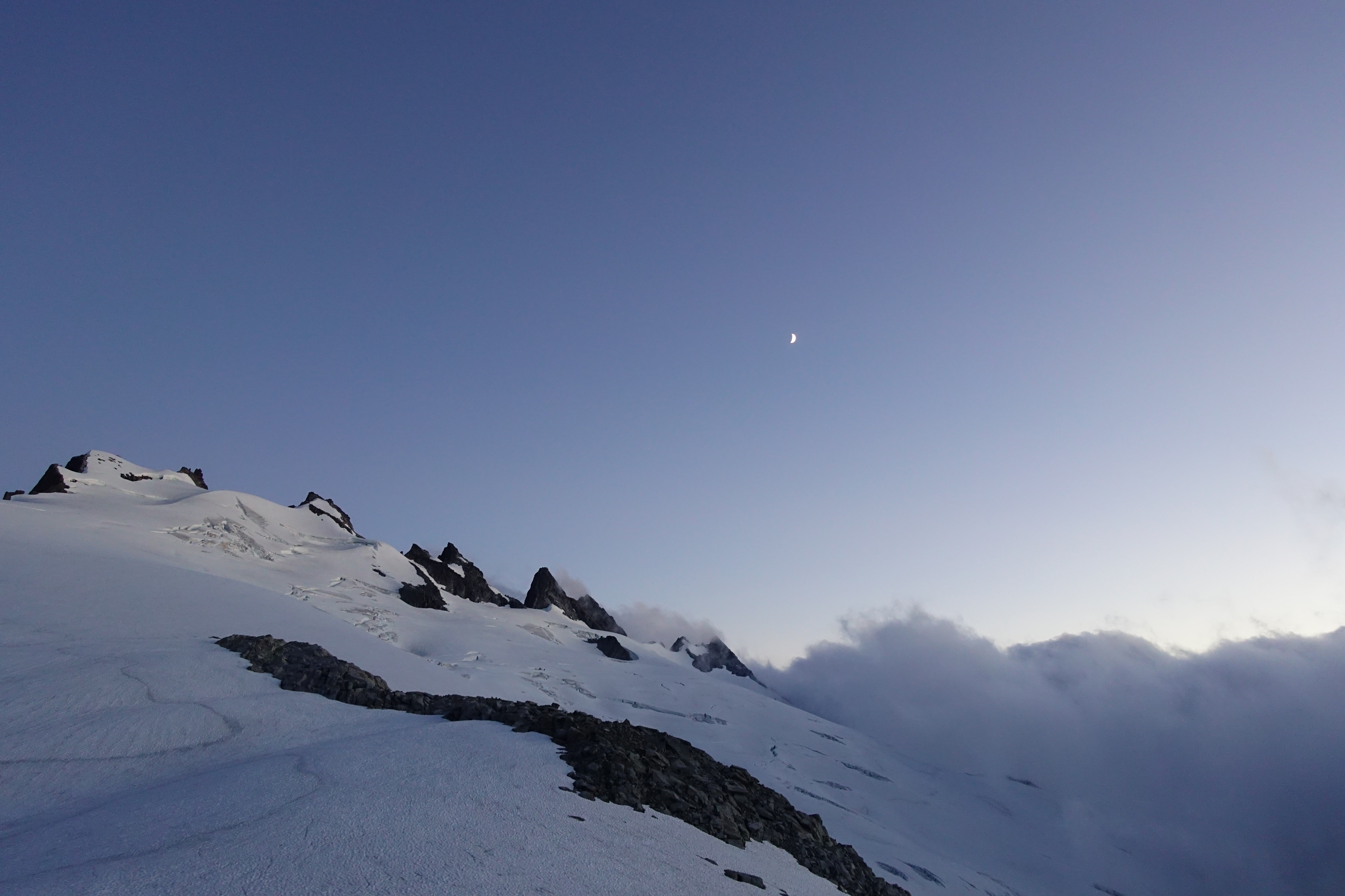
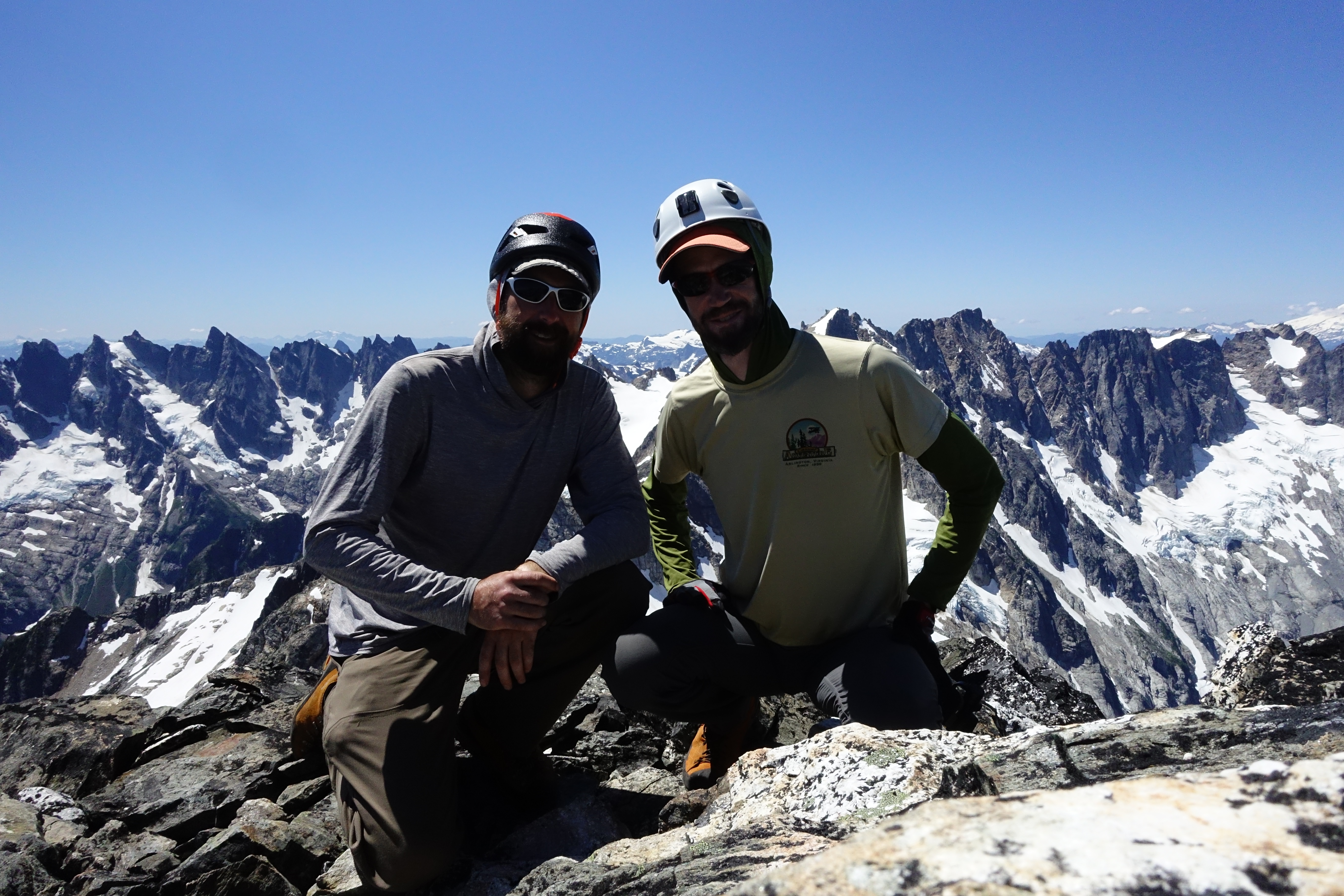
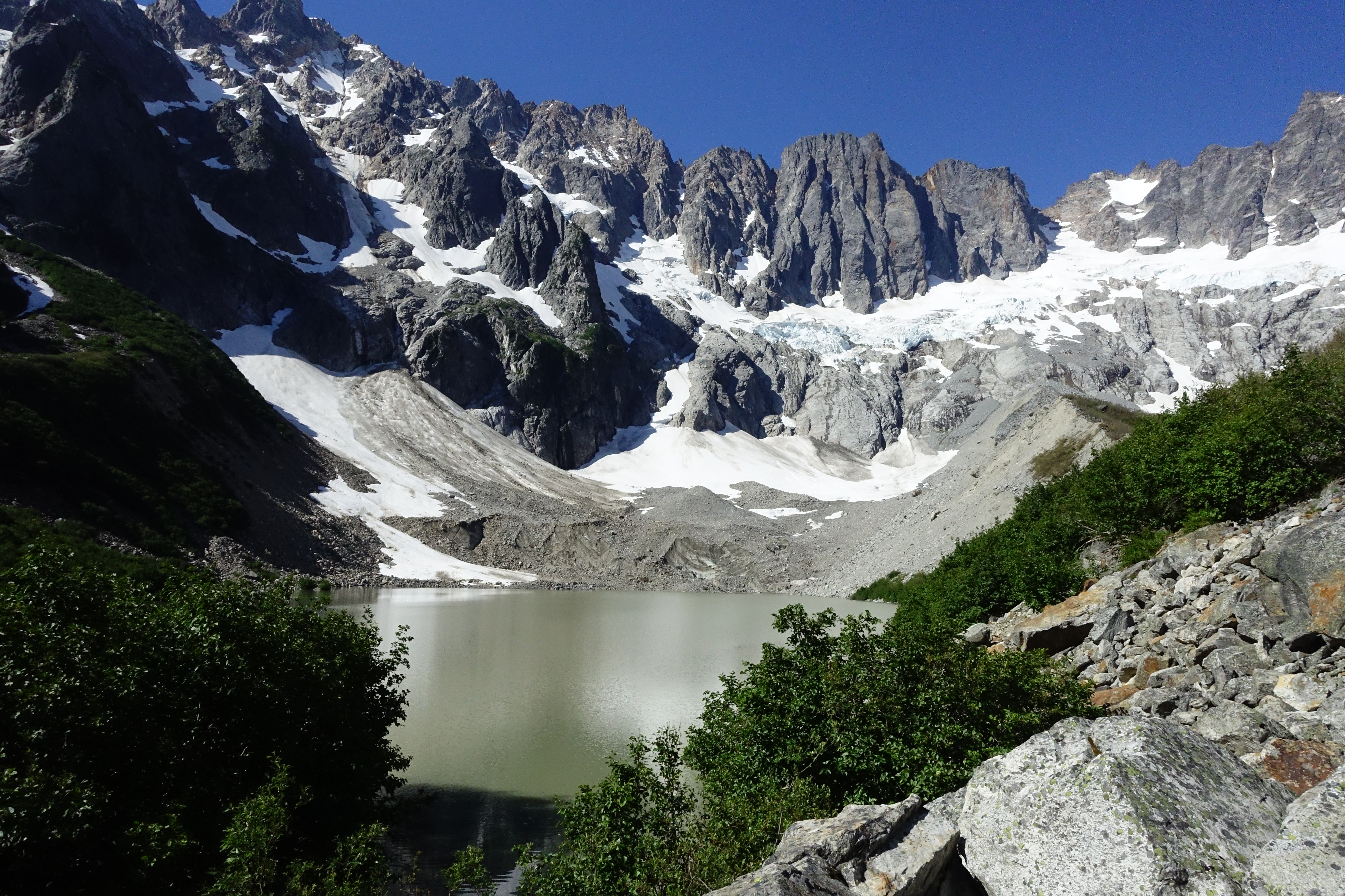
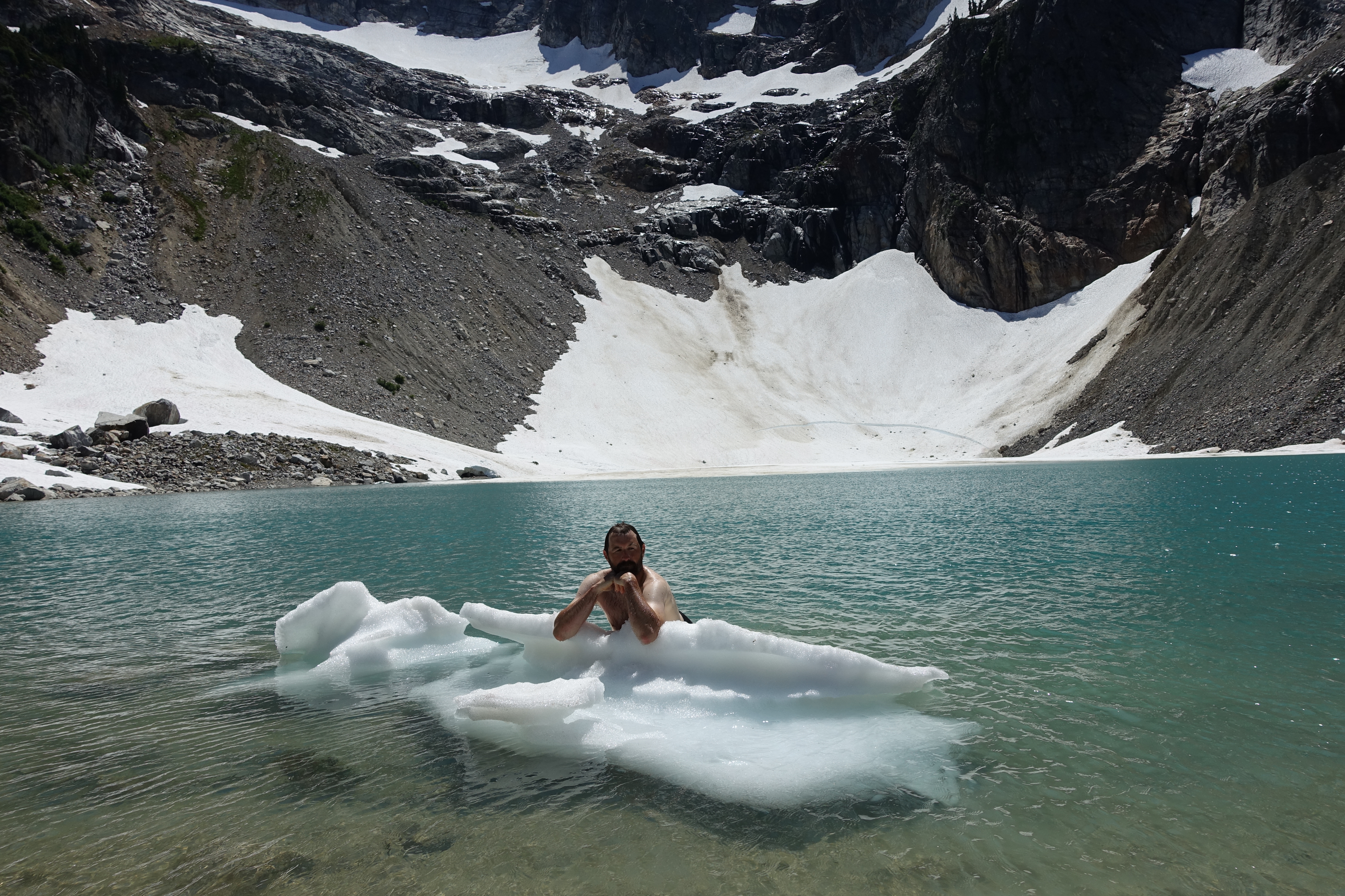
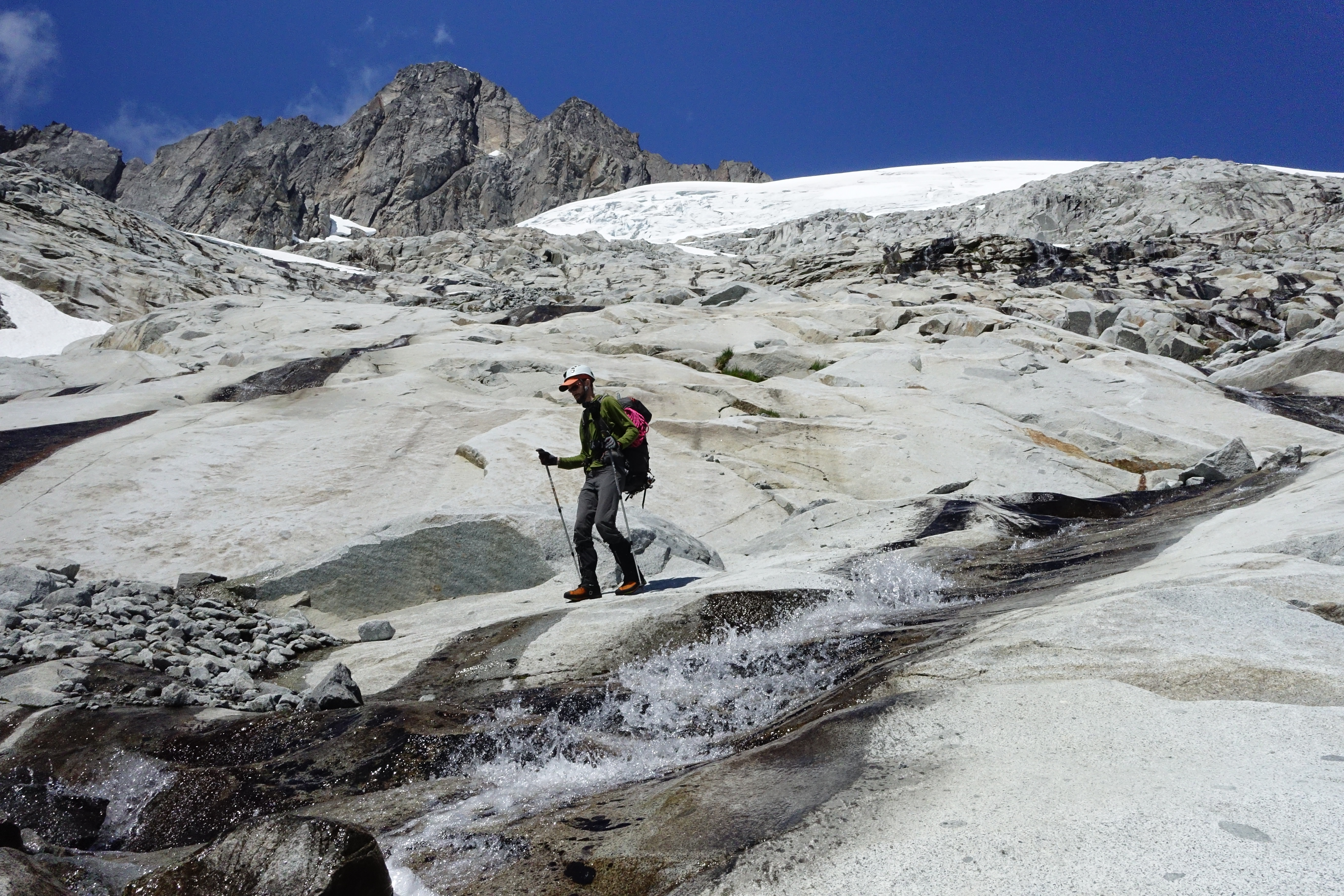
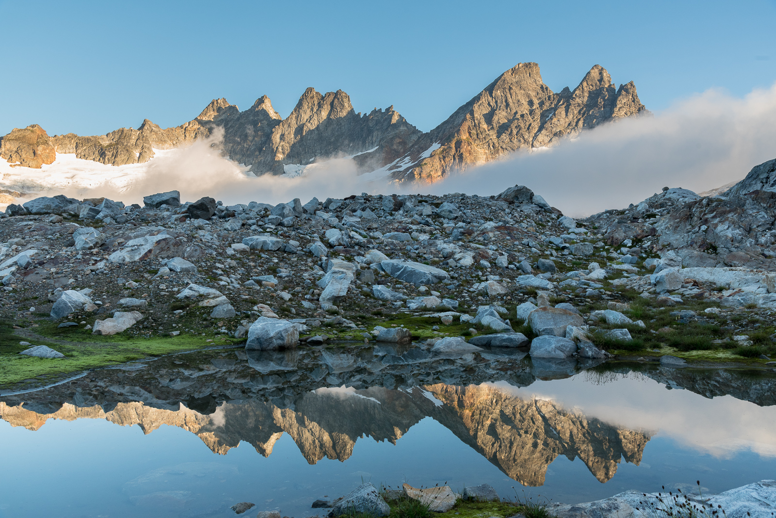
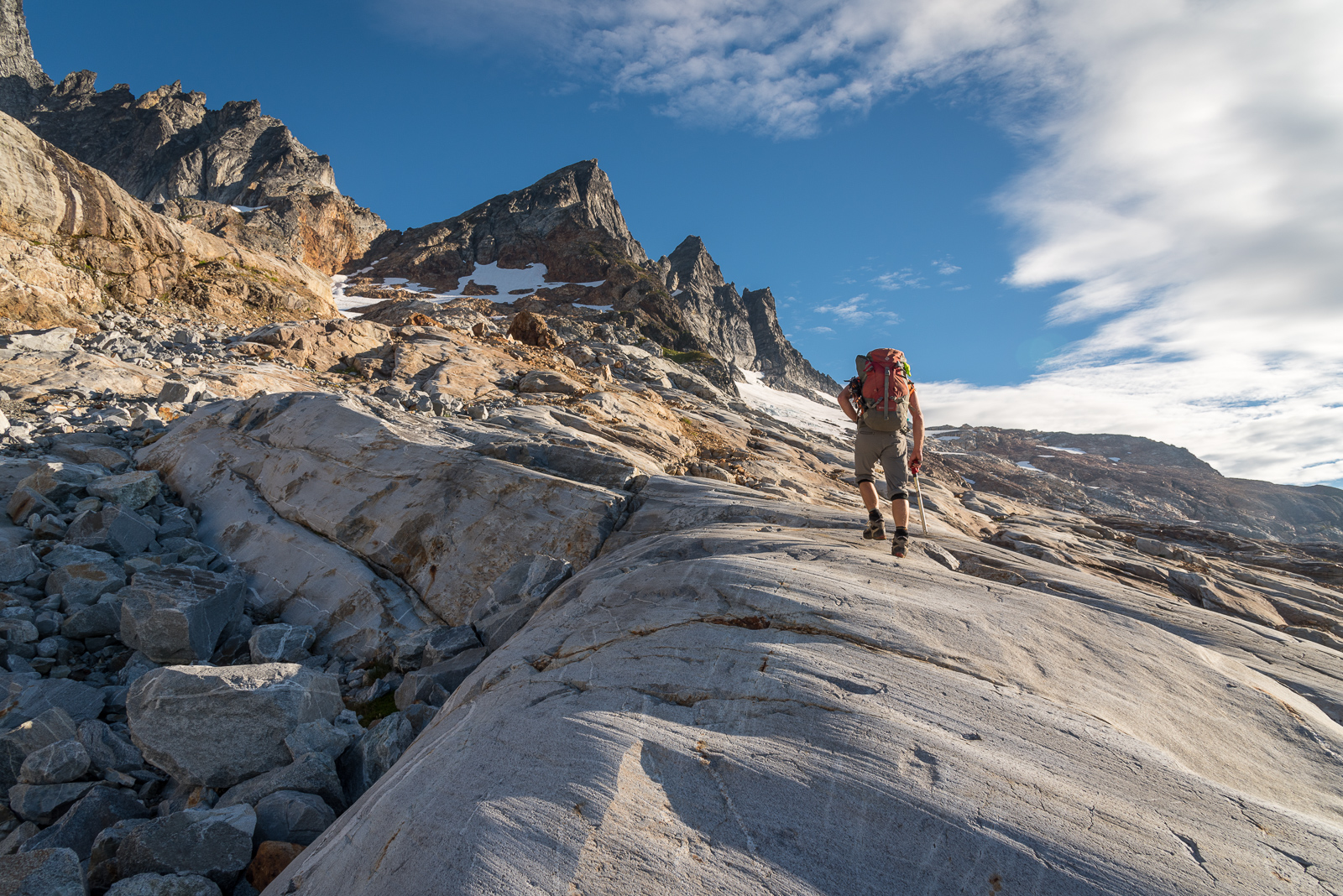
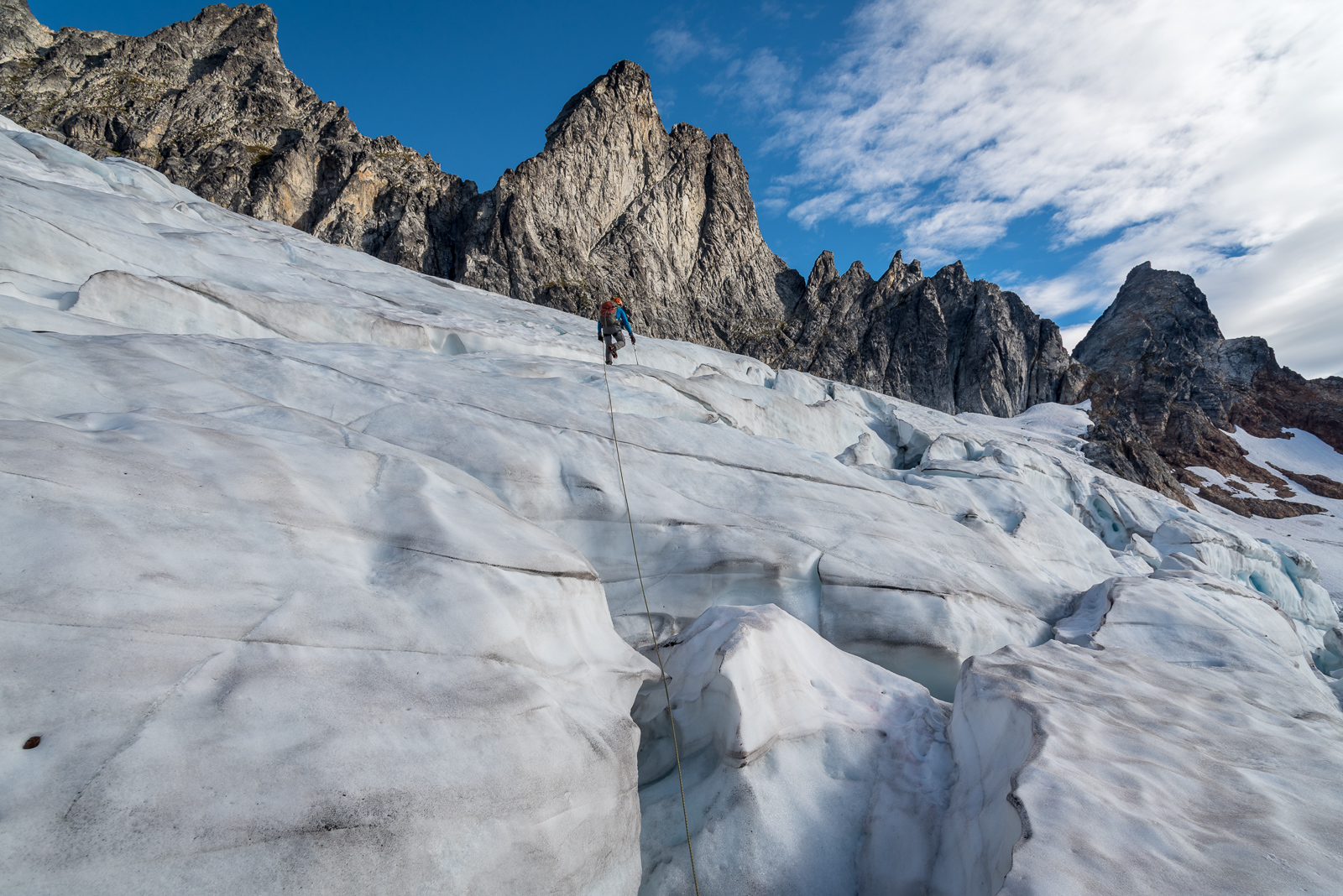
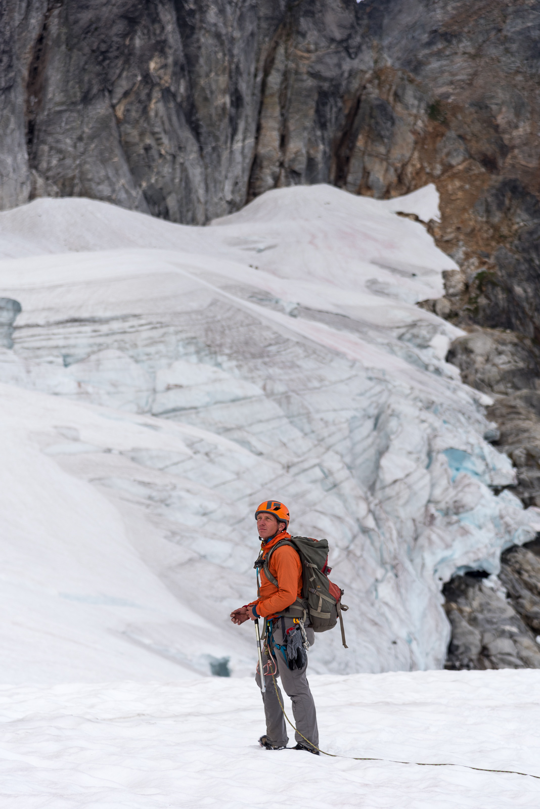
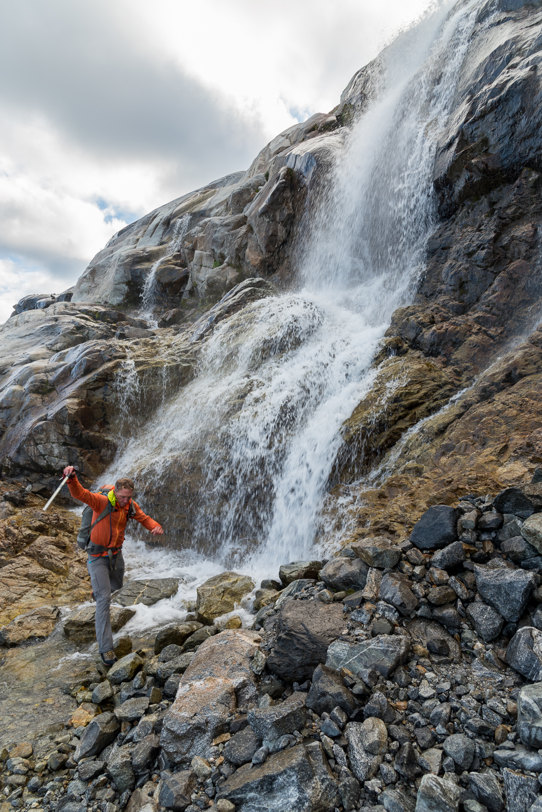
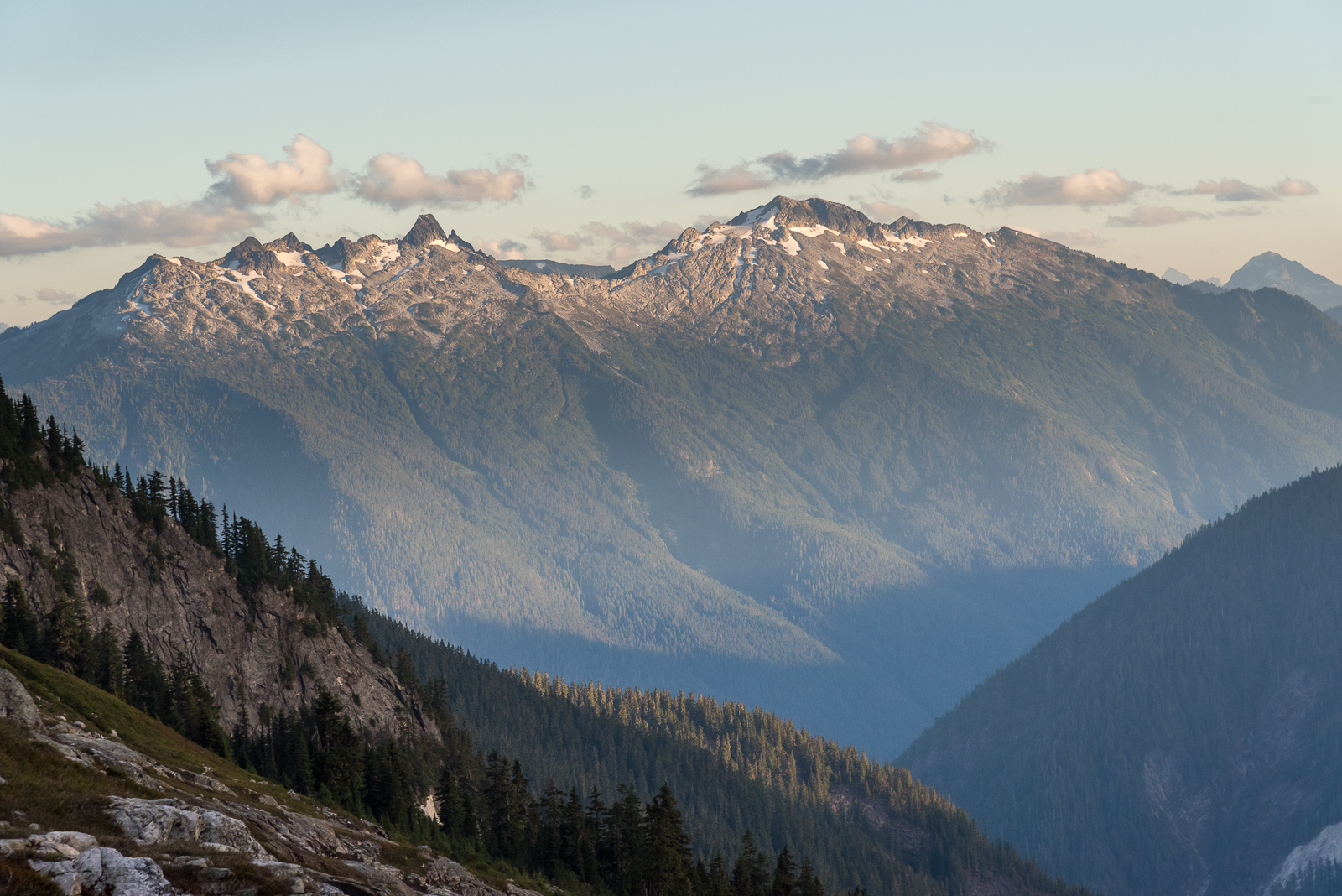
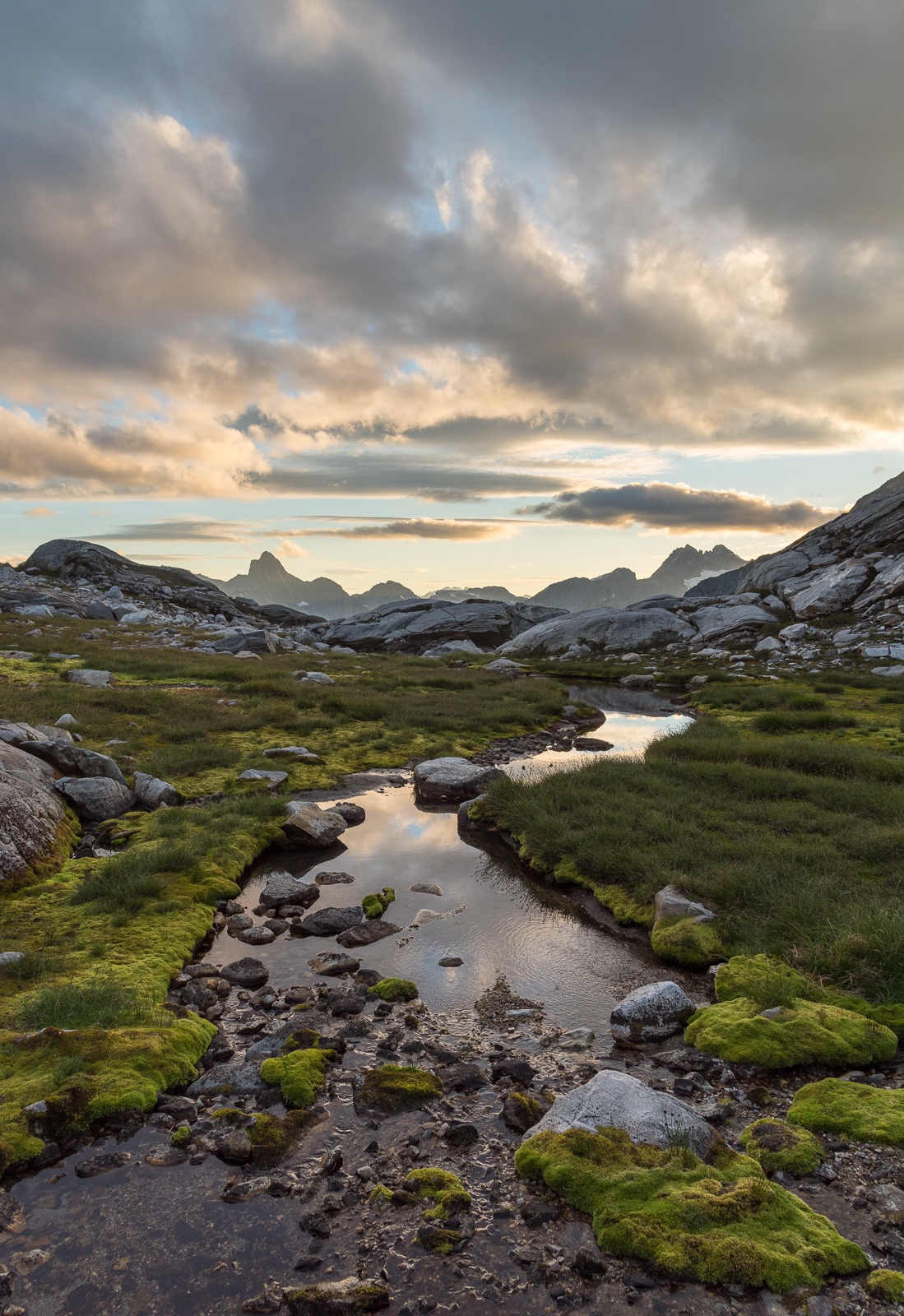
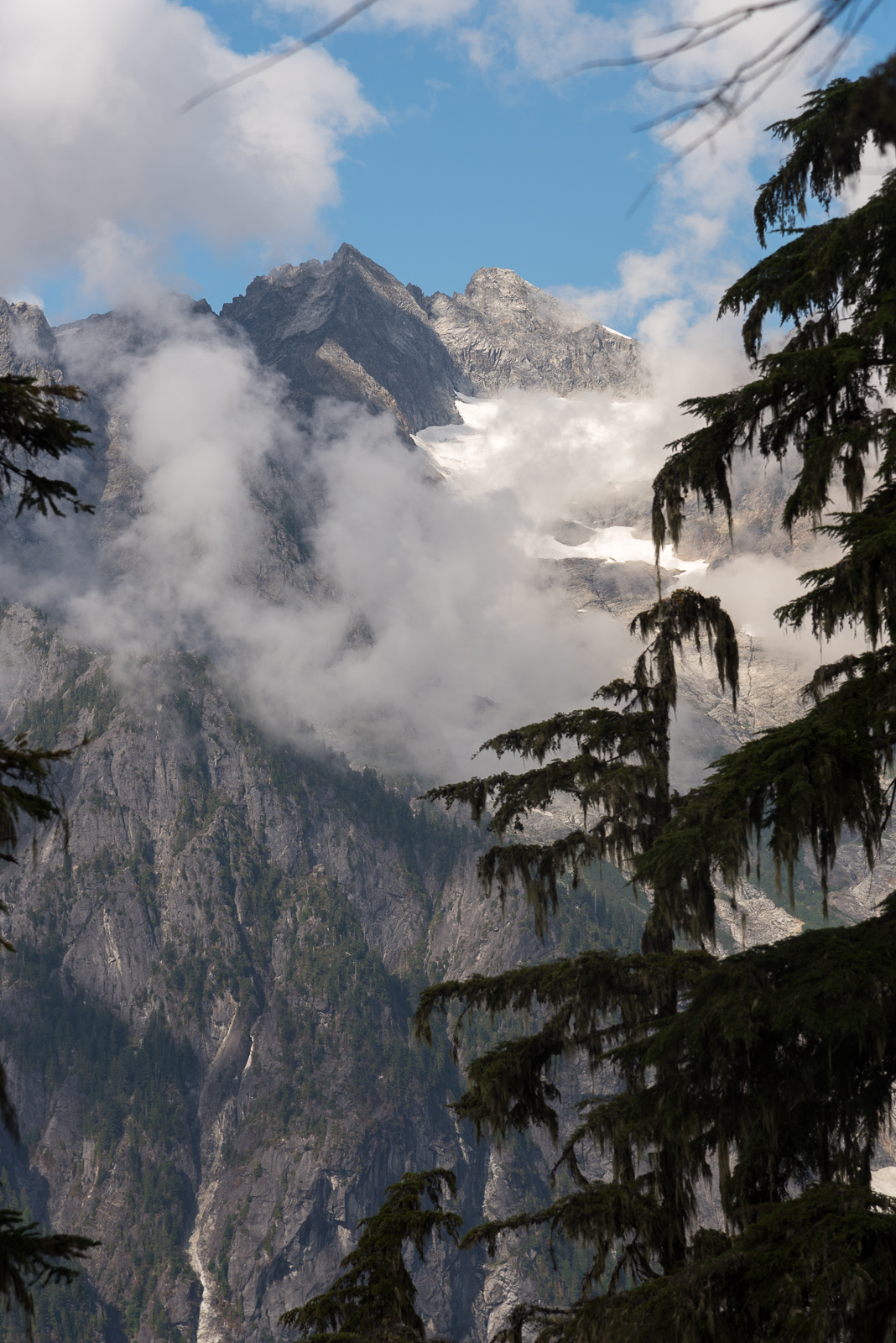
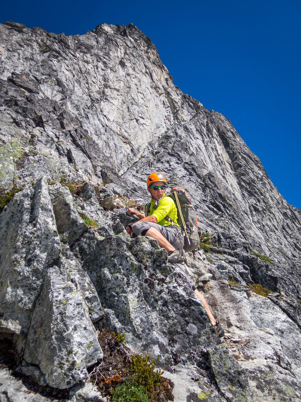
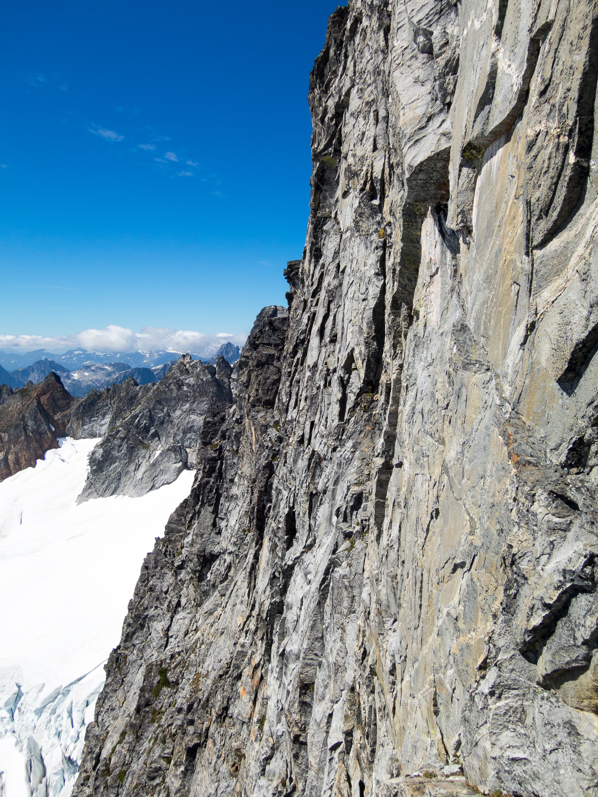
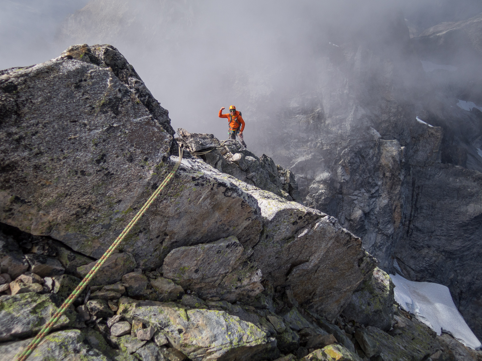
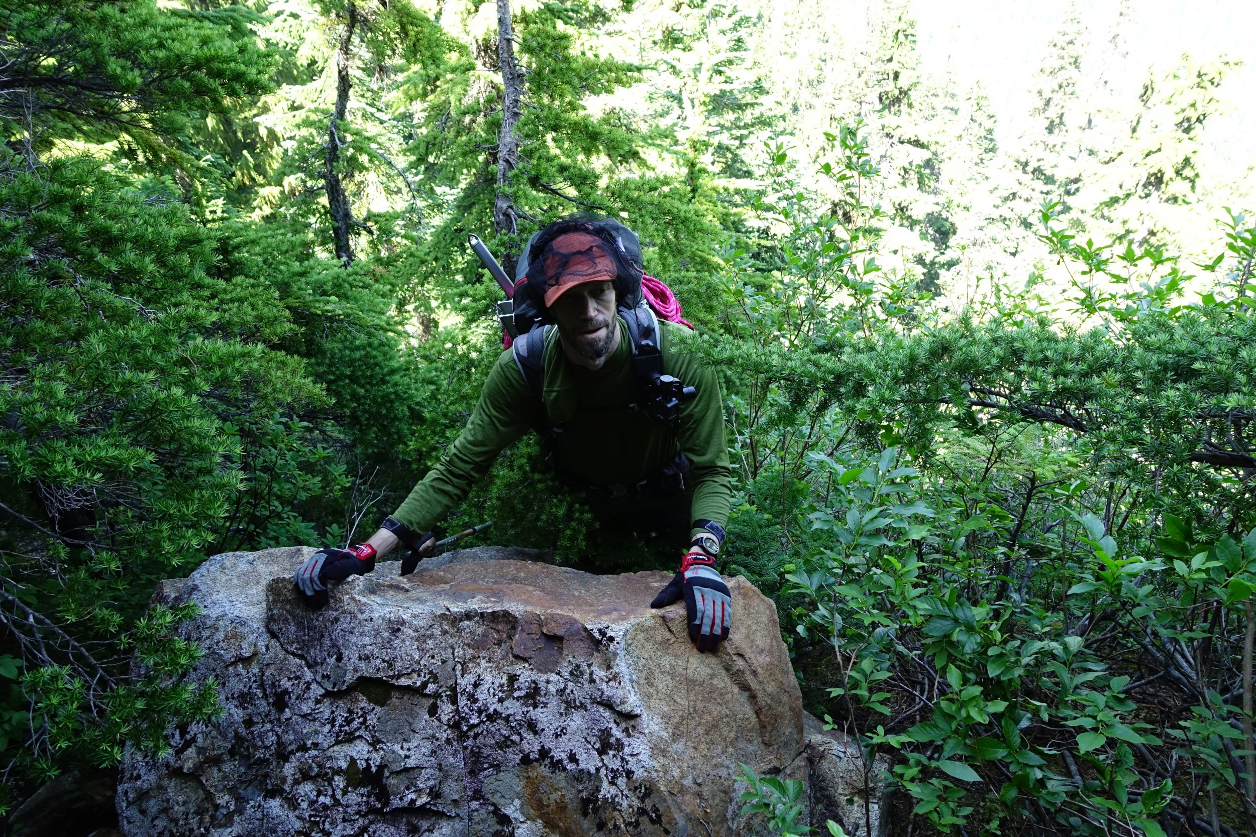
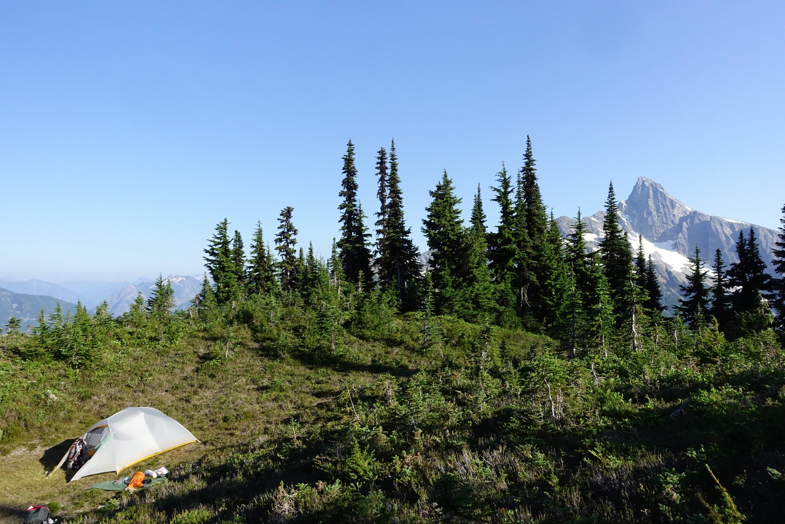
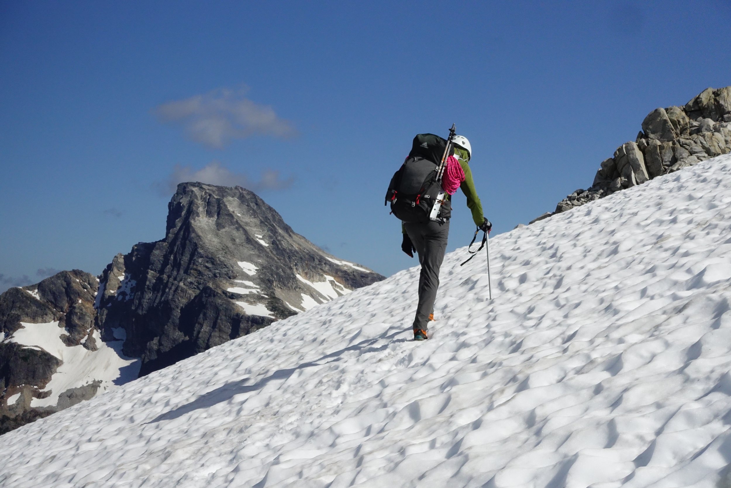
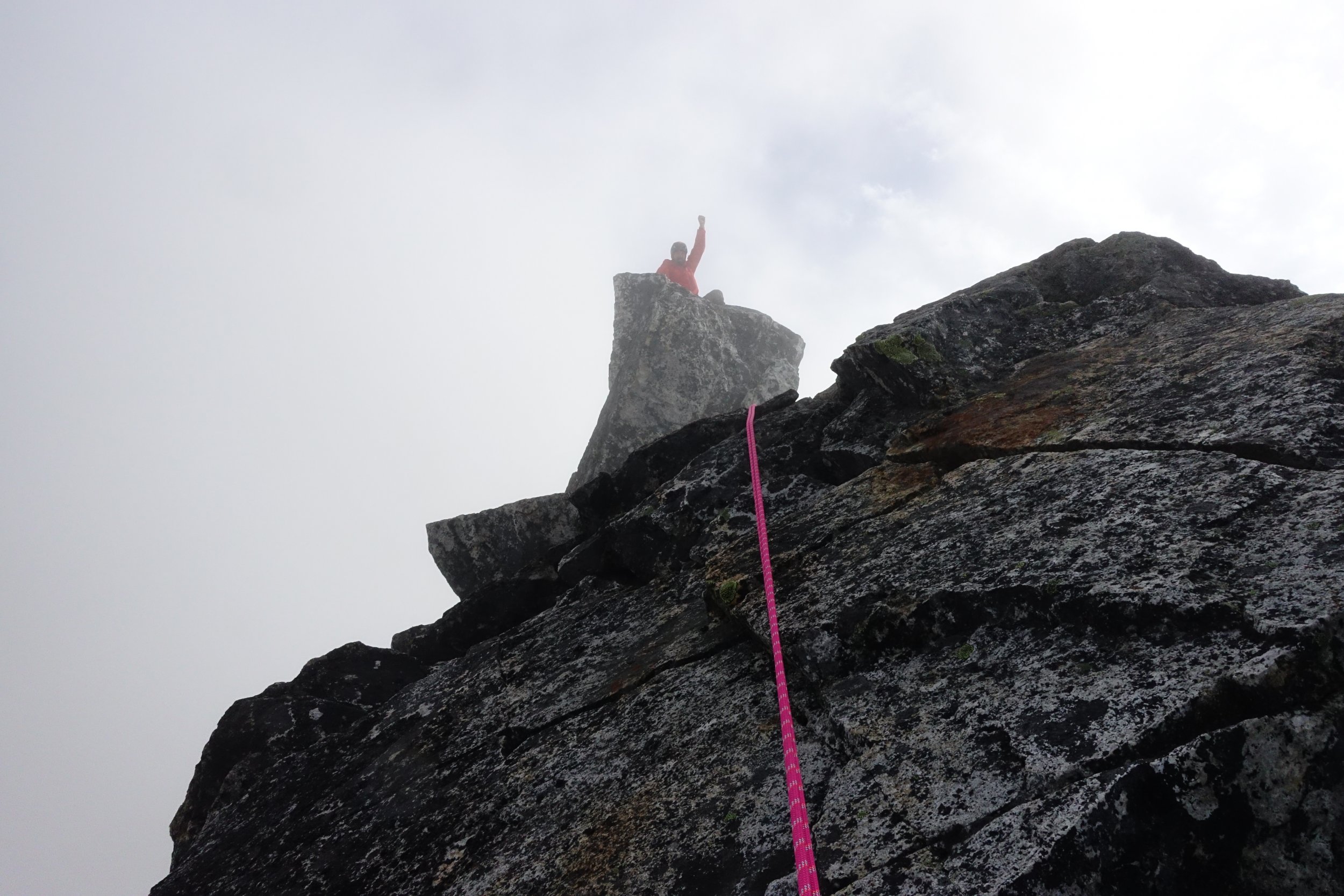
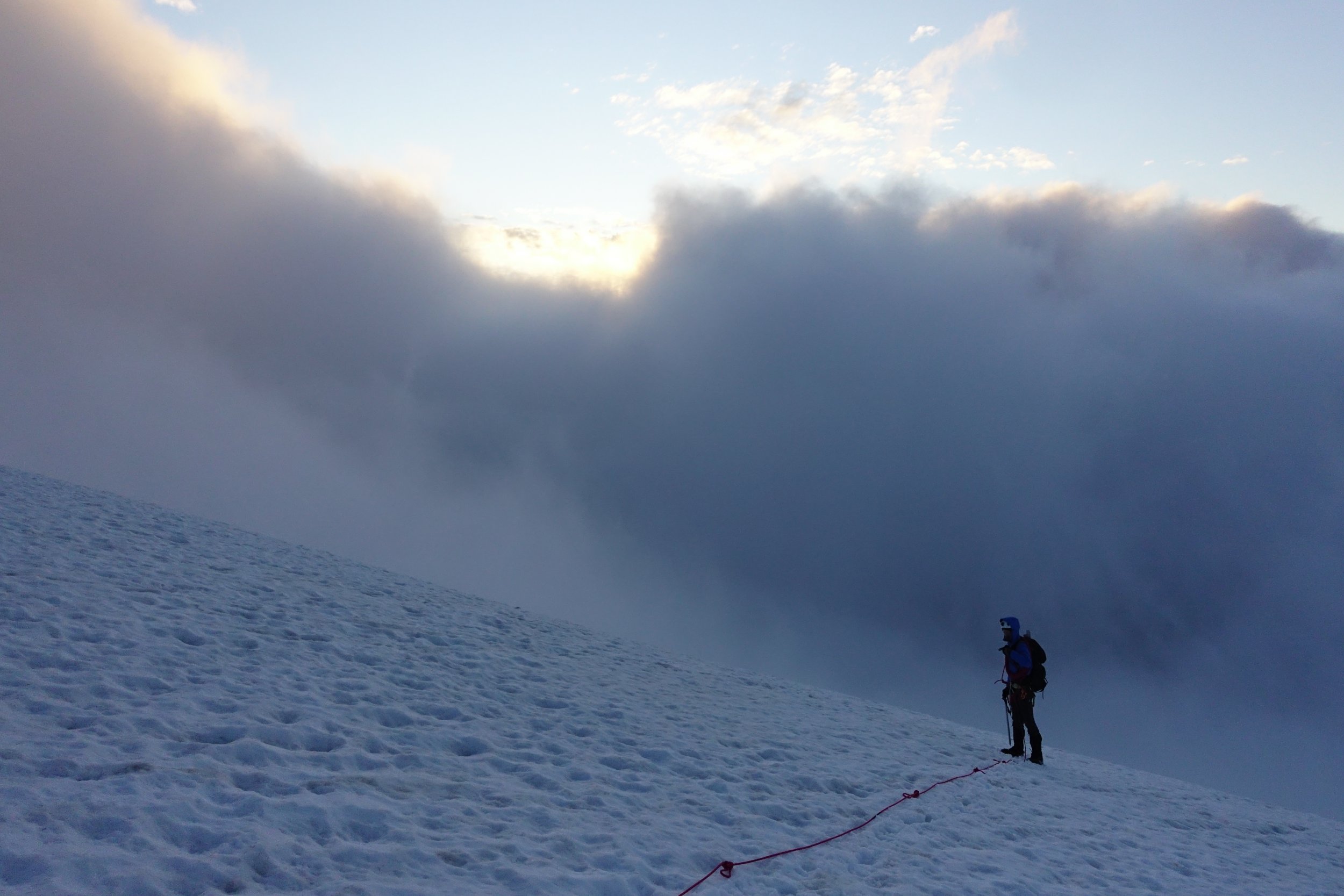
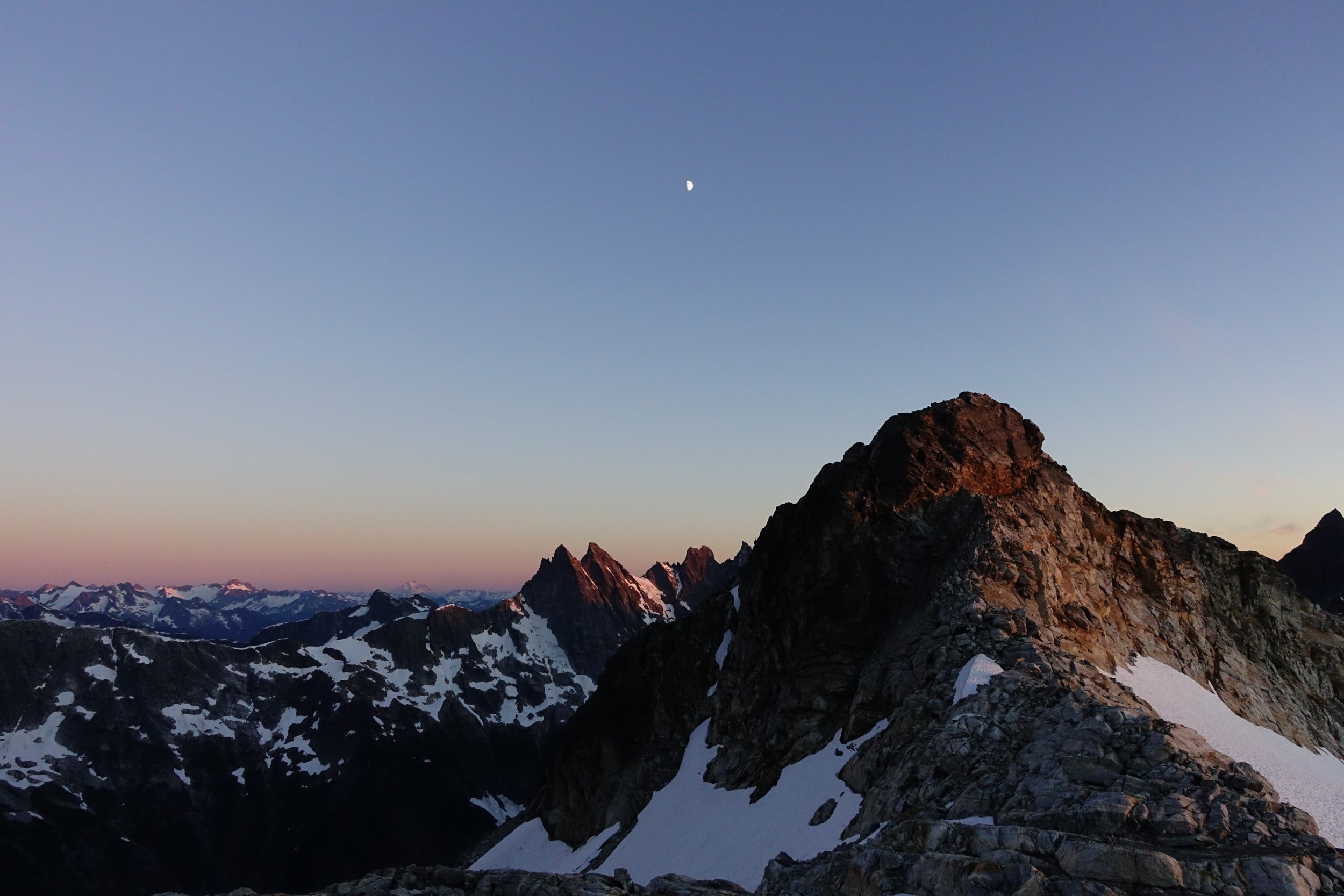
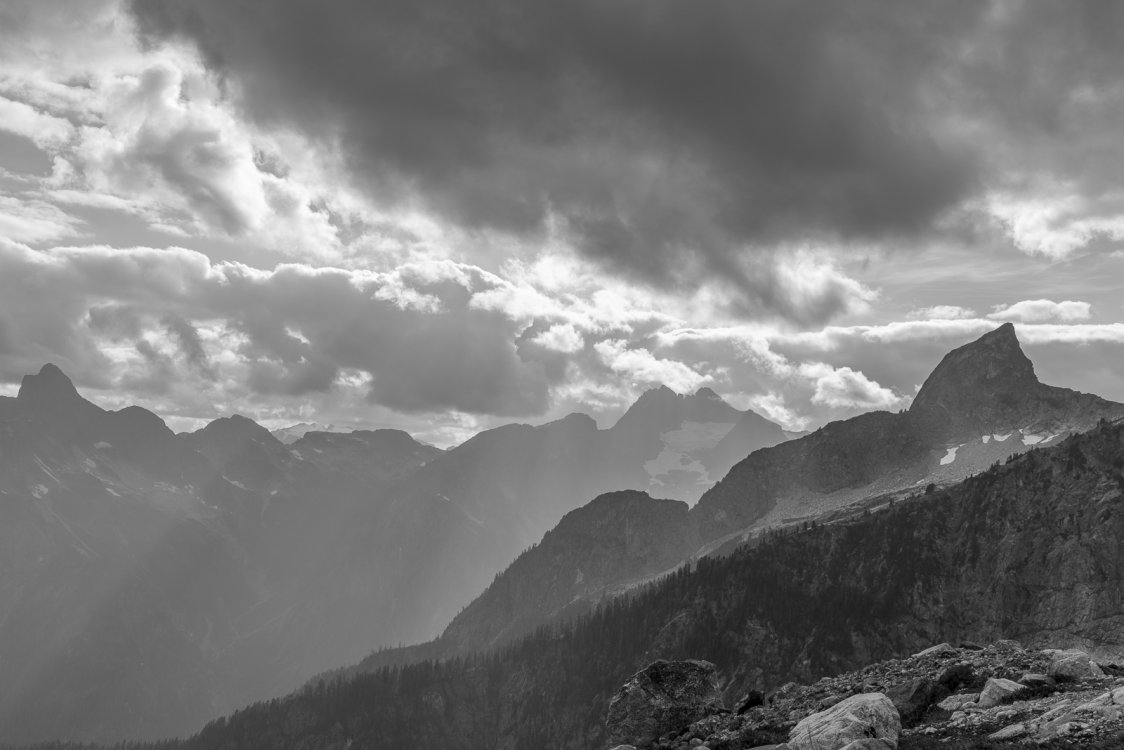
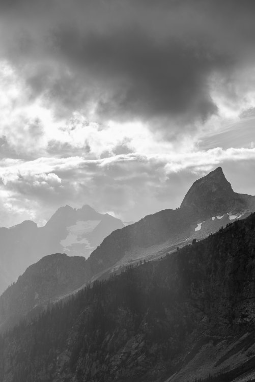
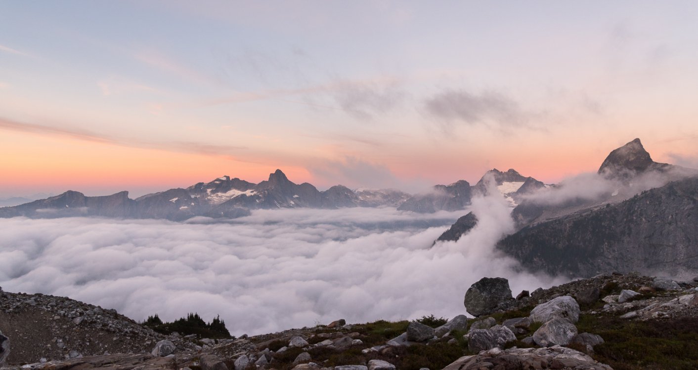
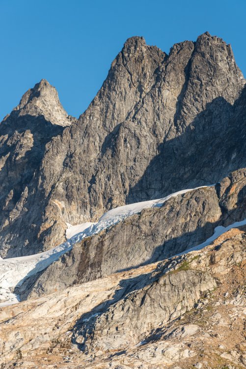
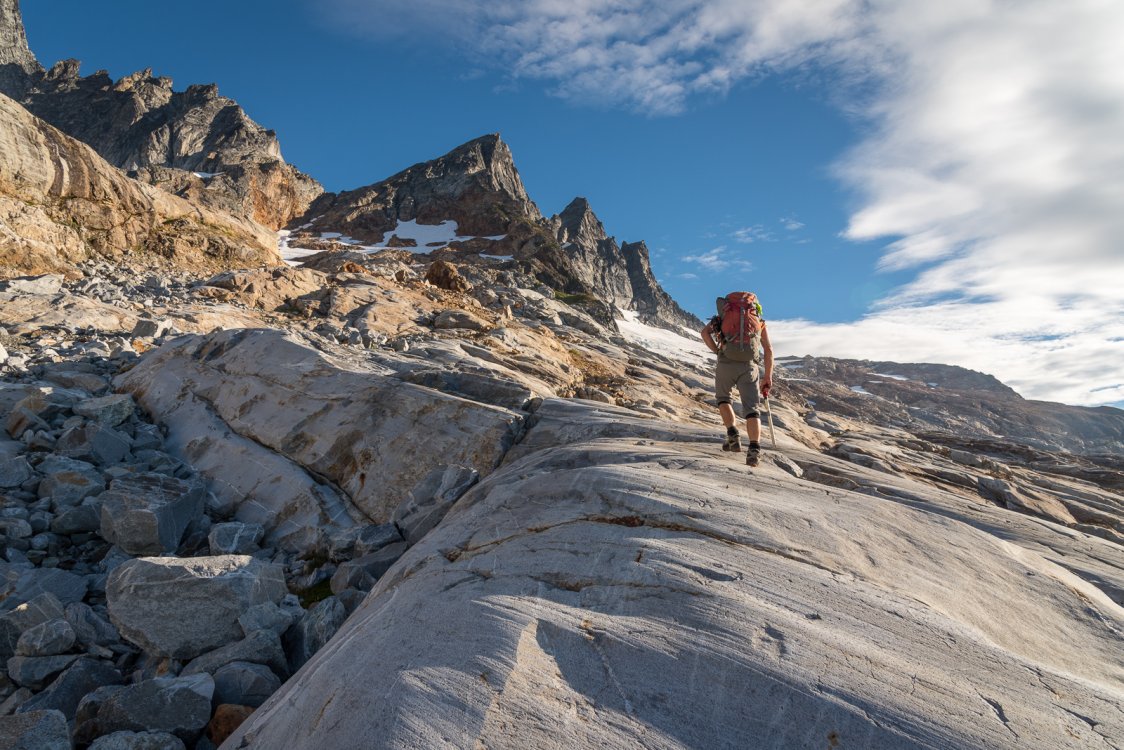
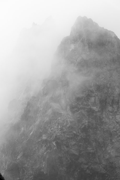
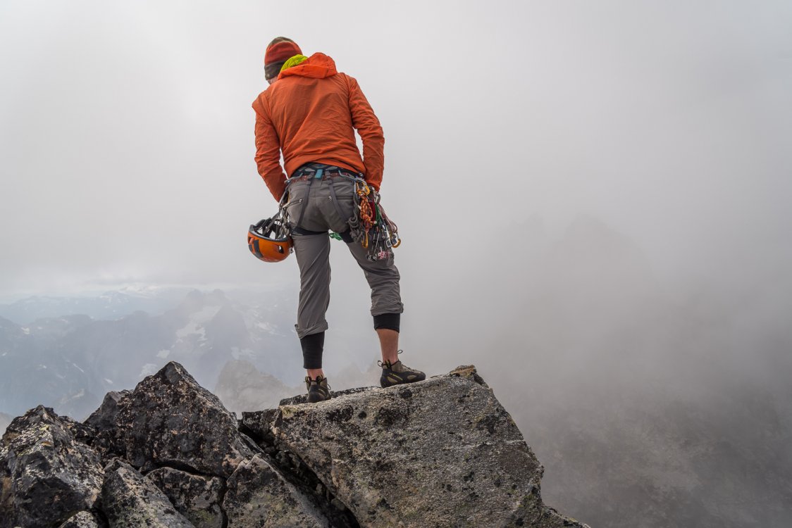
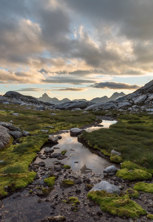
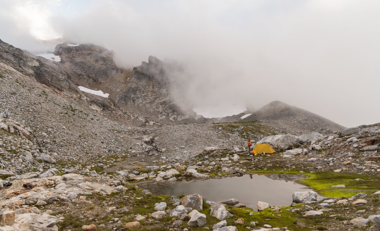
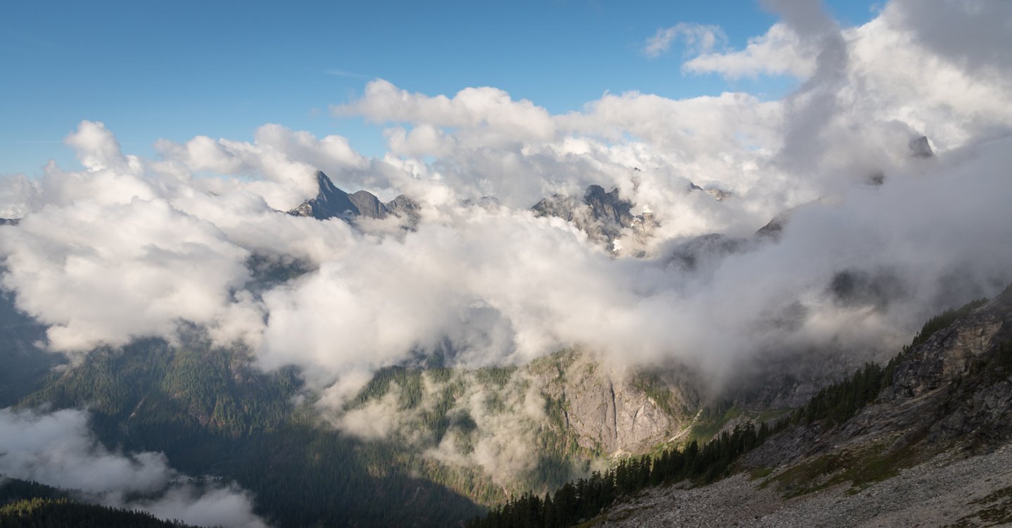
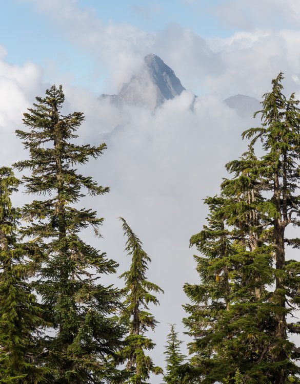
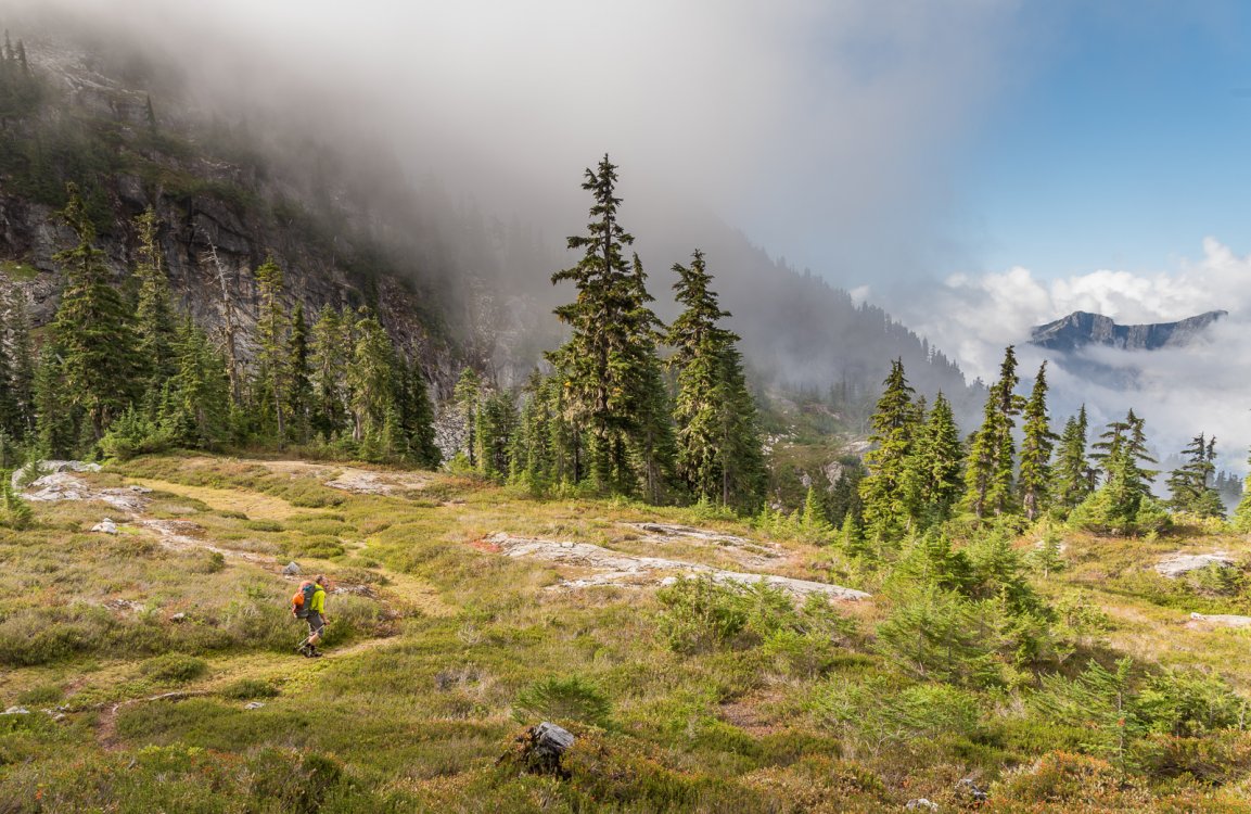
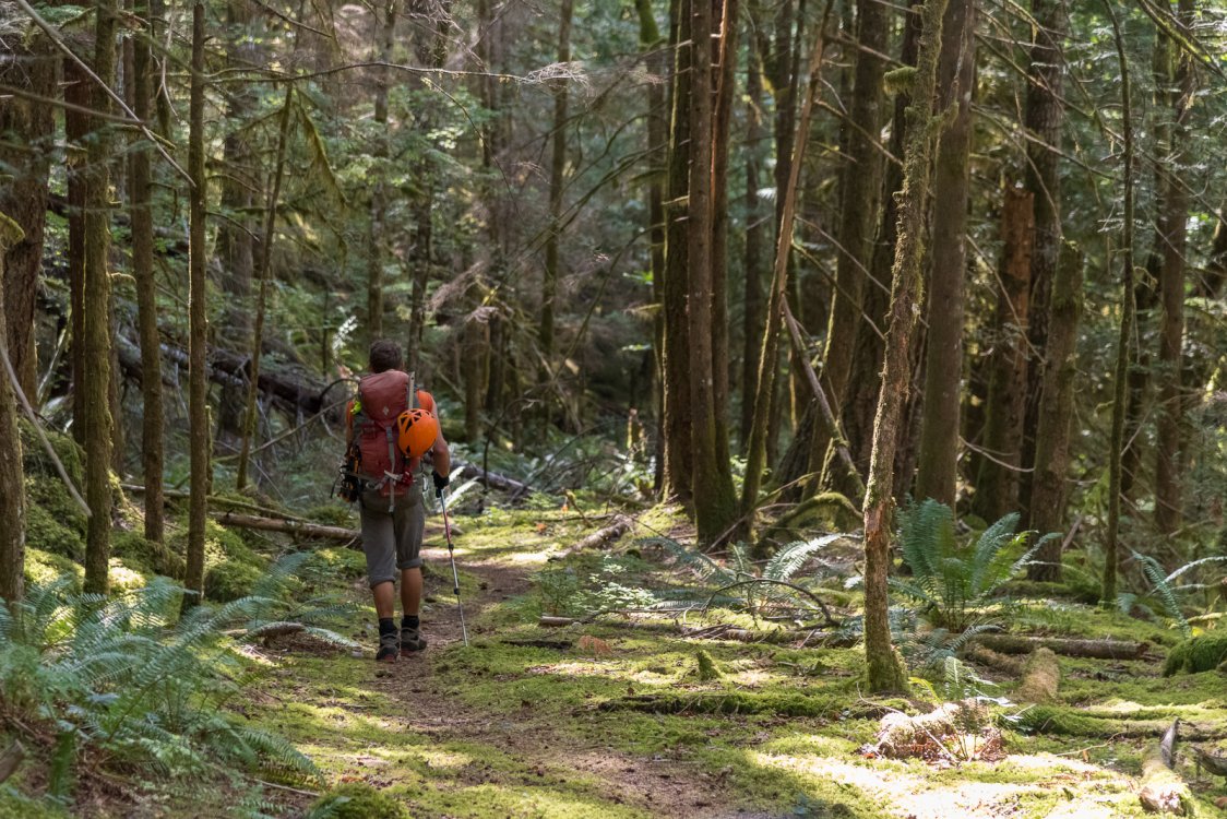
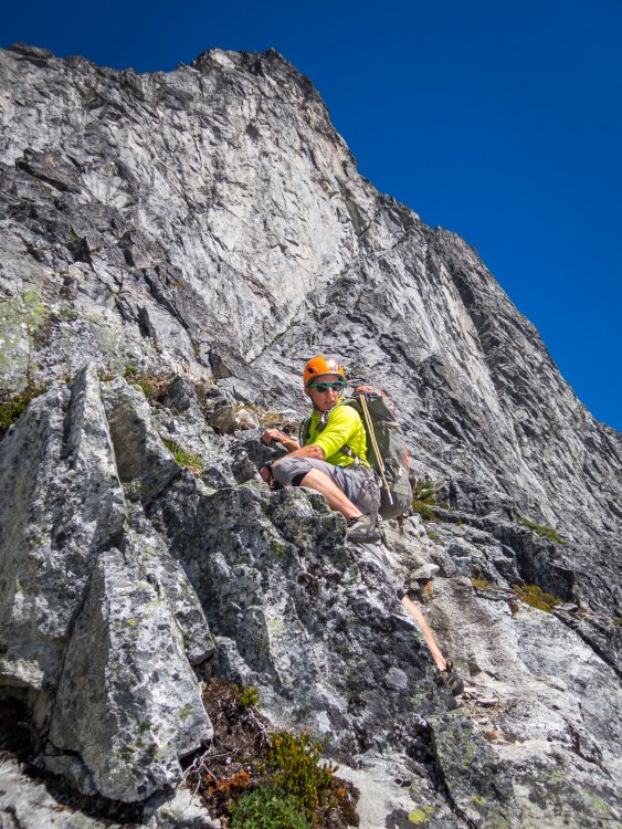
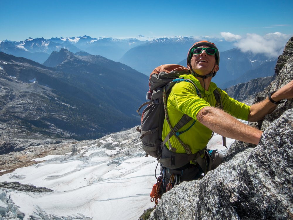
 Trip: Northern Pickets - Phantom Peak, Challenger 1/2/5, and "The Bat Wing" Date: 7/30/2015 Trip Report: Over the past year plus, Mario (a prolific Pickets schemer) had sold me on the idea of completing a North-South Pickets traverse this summer. We had attempted this traverse in 2008 but, after several days in a whiteout near Pickell Pass, with dwindling food, time, and spirits, we abandoned the route Southward and ended up going out to the East. I had taken the last four years off from Picketeering as a new father, but the idea of seeing Picket Pass firsthand was a big draw for me, a sideways summit of sorts. However, as this year's trip came closer, several facts became apparent. First, snow conditions were historically low, making the traverse route more dicey. Second, Mario was, as he puts it, "getting old" and was going to need to tap out of the trip due to a number of nagging injuries. This left Sandy, Matt, and me wondering about objectives. In 2009, when doing new routes in the Challenger group, i recall looking into the heart of the Northern Pickets and seeing the profile of Phantom, with its West Ridge dropping towards Picket Creek. In 2011 Keith, Mario and I made an attempt, but in classic Pickets fashion, the weather closed in and shut us down. This year seemed like a good opportunity to go take a closer look. There is no simple way into the Northern Pickets. As Select Climbs says, "the pilgrim pays a price." Perpetually hopeful for a break, we tried hiking from Hannegan to Whatcom Pass, and around Whatcom. While this approach is long, it is also scenic, relatively gentle, and has almost zero bushwhacking, and so less sucky for big packs on the way in. The initial hiking went smoothly. Sandy was Mr. Water, whipping out the Steripen (scary-pen?) at every stream to keep up sloshing happily along. The only setback was that Matt's shoulder strap attachment blew apart under the load, but Sandy came up with a nifty field repair that saved the day. Leaving the trail and the people behind, we moved towards the Whatcom glacier. The icefall this year is scary. With so little snow, the ice that is there seems more active than normal. We hustled across, and began scheming alternate return routes. I felt more anxious than i recall from previous Pickets forays. The ever-increasing remoteness and commitment as you head deeper in are always factors here, but with increasing age i also have a greater appreciation for my own mortality, and most importantly an extremely strong desire to be there for my little girl growing up. As we made camp on the rock benches on the Southeast side of Whatcom, i wondered what the heck i was doing there. Morning brought improved spirits. Briefly... until we watched a snowfield on Whatcom's South side spontaneously crumble into ice blocks ahead of us. Hmm, yeah, lets definitely hike up higher and get above all this crud. Studying the Challenger glacier brought more concerns. The standard low route from Perfect Pass was out, broken into a thousand shards. We'd need to figure something else out. Heading straight up the ridge above Perfect Pass towards Point 7696 until we could gain the glacier higher seemed like our best chance. We hadn't been that way before, but it turned out to go just fine. We passed debris and then the plaque from the 1980 Firewood One helicopter crash. After some fine alpine rambling, we reached a saddle with good glacier access. Although the upper glacier was more open than i have seen it before, Matt was able to pick a fine route and soon we were at Middle Challenger Col. Shenanigans ensued. The spot at the East edge of the col where we have rapped twice before was unreachable due to larger than normal moats. An alternate rap station on the West edge looked promising, but with the low snow year it didn't look like our single 60m rope would reach the glacier below. We threw it down to measure, it didn't reach, and so we decided to pull it up and instead try the route between Challenger 4 and 5. However, the rope got wedged trying to pull it up. I threw on rock shoes, rapped down, and cleared the rope. However, once down there it was clear we could easily set a second station and make the route go, and so we reverted back to plan A. The second rap involved some moat wrangling, but eventually, after much wasted time, we made it through. Feeling a bit short on daylight and energy to make it to the Phantom alp-slope camp, we decided to camp at a beautiful site below Crooked Thumb. In the morning we set out for Phantom. Interminable scree fields, and lots of going down in order to go up, made us happy to have day packs instead of our full kit. (photo by Sandy) As we approached, i kept looking up at Phantom's West Ridge and wondering/doubting if i had the mojo for an FA. I kept my mouth shut, in that chess game of climbing partners wondering which way the moods would align. Arriving at the saddle in the ridge, I got my answer. Matt said no way to the unclimbed ridge, which brought me 95% relief and 5% disappointment. Sandy then pulled out his crocs (which he had stealthfully brought from camp) and declared that he was going to spend the day soaking in the view from right there at the saddle. (photo by Matt) And so, Matt and I, with excitement, set off on the Southwest route on Phantom. The cleft between Phantom and Spectre is an awe-inspiring place. Spires jut up all around you. The Haunted Wall looms overhead. The sense of remoteness is massive. The first 1000' went rapidly up what little glacier remnant remains. (Throughout the range, many of the glaciers look withered. A few more dry/warm years and some will be gone. Geologic time is now!) Then we cached our boots and snow gear, and switched to rock shoes. Scrambling the next 1000' over surprisingly clean rock brought a great sense of flow. As i moved the last few feet to the crest, i realized we were at a false summit. The traverse to the true summit looked sketchy, so we took out the rope and rack and i led over lichen-crusted plates to the top. (photo by Matt) The position was amazing. I though of Wayne and Josh on their Northern Pickets traverse in 2005, and Jens and Chad in 2013 on their complete Pickets traverse, and wondered what they must have felt on this summit, with more spidering narrow crests yet to run. Matt came over, and we opened the summit register. The feeling was what i picture an archeologist feels opening a tomb in Egypt's Valley of the Kings. There was Fred and Helmy's first ascent entry from 1940, followed by a list of fellow Picketeers, only about two dozen recorded parties in all. In ten trips to the Pickets, this felt like my most wild summit yet. The descent demanded full concentration, and so when we reunited with Sandy at the saddle, we were happy but drained. Splashing in the meltwater streams at the Phantom alp-slope campsite was pure joy, but the hike back up and across the boulders was pure scree-vil. Exhaustion ensued. Followed by celebration. Followed by turning off the alarm for the next morning. While Spectre and Swiss had been on the maybe list heading in, at this point they were taken out of consideration. Our new plan was to go get some various Challenger summits. Matt hadn't been up main Challenger yet, and i wanted to tag some of the sub-summits. We packed up and headed up the new to us route around the back of West Challenger on ledges, which went smoothly. Then we continued over the Solar Glacier, to the Challenger 4-5 Col. There we made camp complete with lovely paved patios for both tents. Let me tell you, these boys can dig and landscape! That afternoon consisted of a favorite type mountain climbing: finding objectives within spitting distance of camp, that can be tackled with minimal packs and late starts. Target one was Challenger 5 (aka Point 7696). The three of us moseyed West, and then did one steep snow pitch. After that, a short enjoyable rock scramble took us to the summit. I love sharing sunny afternoons in the mountains with great friends like these. After returning to home base, we then set out on objective two for the afternoon: the rather insignificant but attractive ridge just West of the 4-5 Col. I suppose you could call it Challenger 4.33, but we called it The Bat Wing. Matt and i ran the wing-like ridge line, and then a pitch beyond that isn't visible in this photo, to the highpoint. A probable first ascent of something no one cares about. But damn was it fun. That night i expected to sleep soundly but neither Sandy nor I got much rest. At alarm-o'clock Matt and I hopped up, but Sandy pulled the sleeping bag over his head and said something to the effect of "madgamgmmmmamdfgamgdagdmm". Matt and I headed towards main Challenger, bearing high on the glacier all the way to its East edge. From there, the standard path between crevasses led towards the steep final slope and the summit ridge. Matt grabbed the rack and led the money pitch. I love that summit! We soaked in the views, including an impressive mushroom cloud of smoke coming from the Wolverine fire. After backing down the upper snow slopes, we headed for Challenger 2. (photo by Matt) Some easy snow and moat climbing, followed by a rock scramble, brought us to that summit, for me the last one of the five that i hadn't been up. All Five Challengers achievement unlocked! We cruised back to camp, broke it down, and headed down to Perfect Pass. As usual, it was, well, pretty perfect. We choose to descent via Easy Ridge (a cruel name if you ask me). I've been up that way a few times, but going "down" (which has a lot of up) seemed like nearly as much work. The abundant blueberries sweetened the work considerably. After a final night beside the Chilliwack, we hiked back to the trailhead. While we had waited out a couple of days of bad weather in Seattle before starting the trip, we had enjoyed eight days of near perfect weather in the mountains. I'm not sure how many big Pickets trips i have left in me. But, maybe some day i'll get to take my daughter to see Challenger ... now that would be a thrill. Sandy and Matt, thanks for being such great partners!
 -
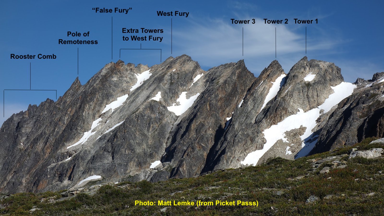
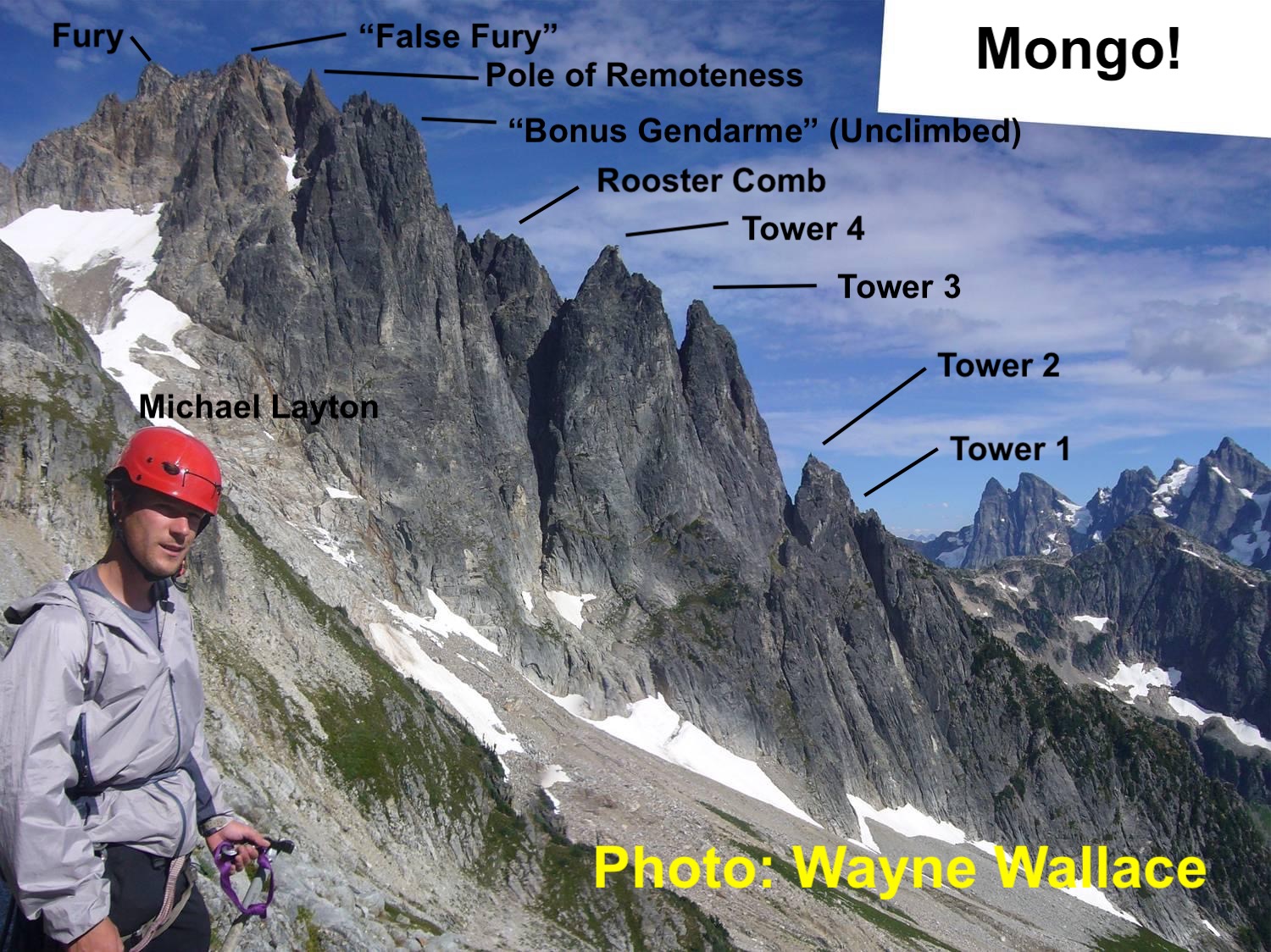
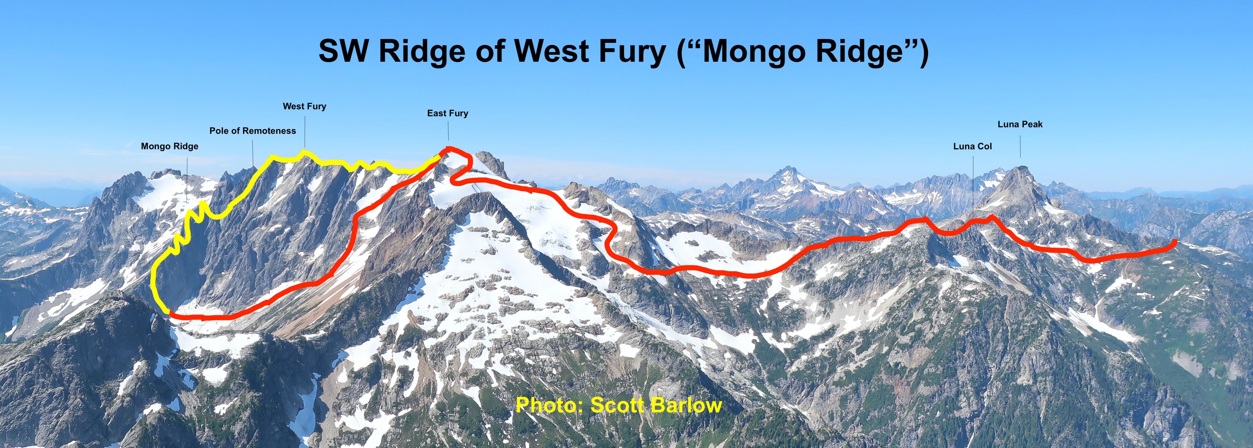
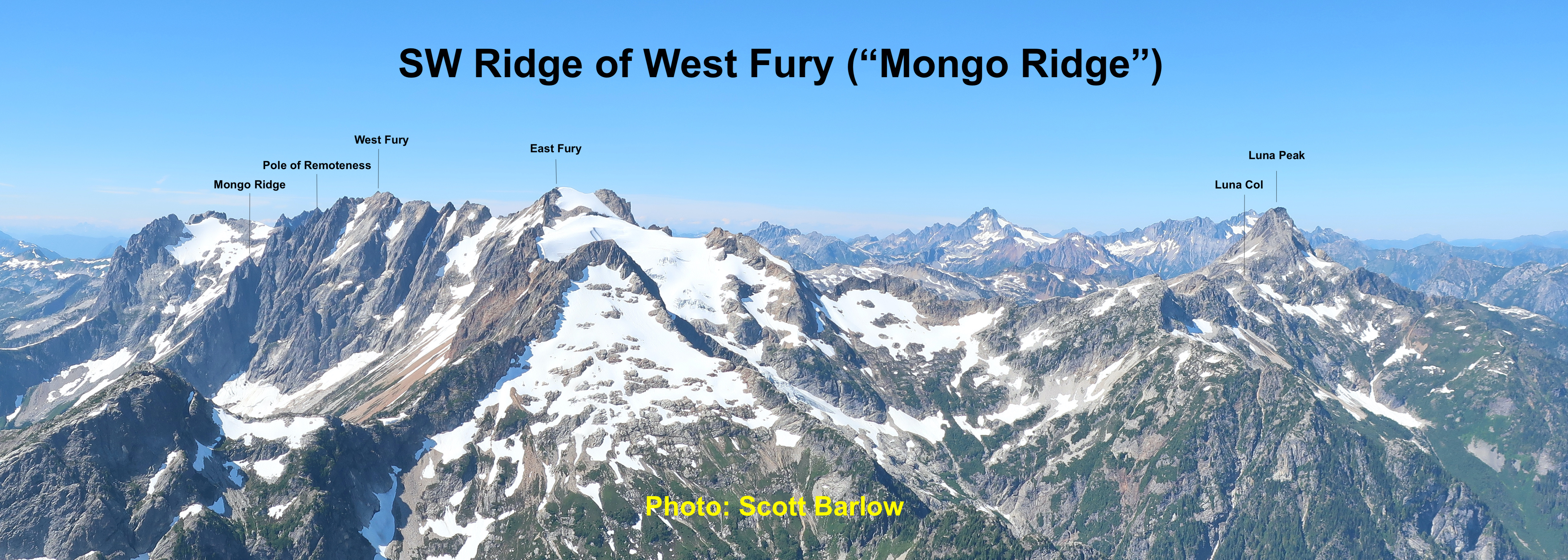
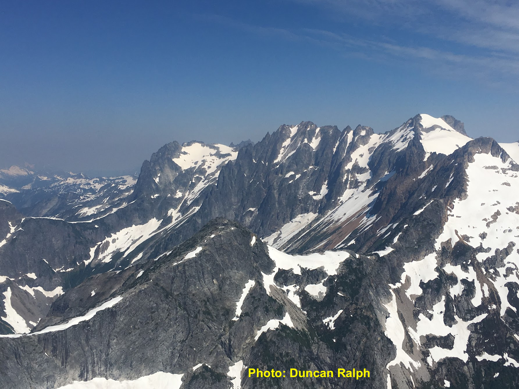
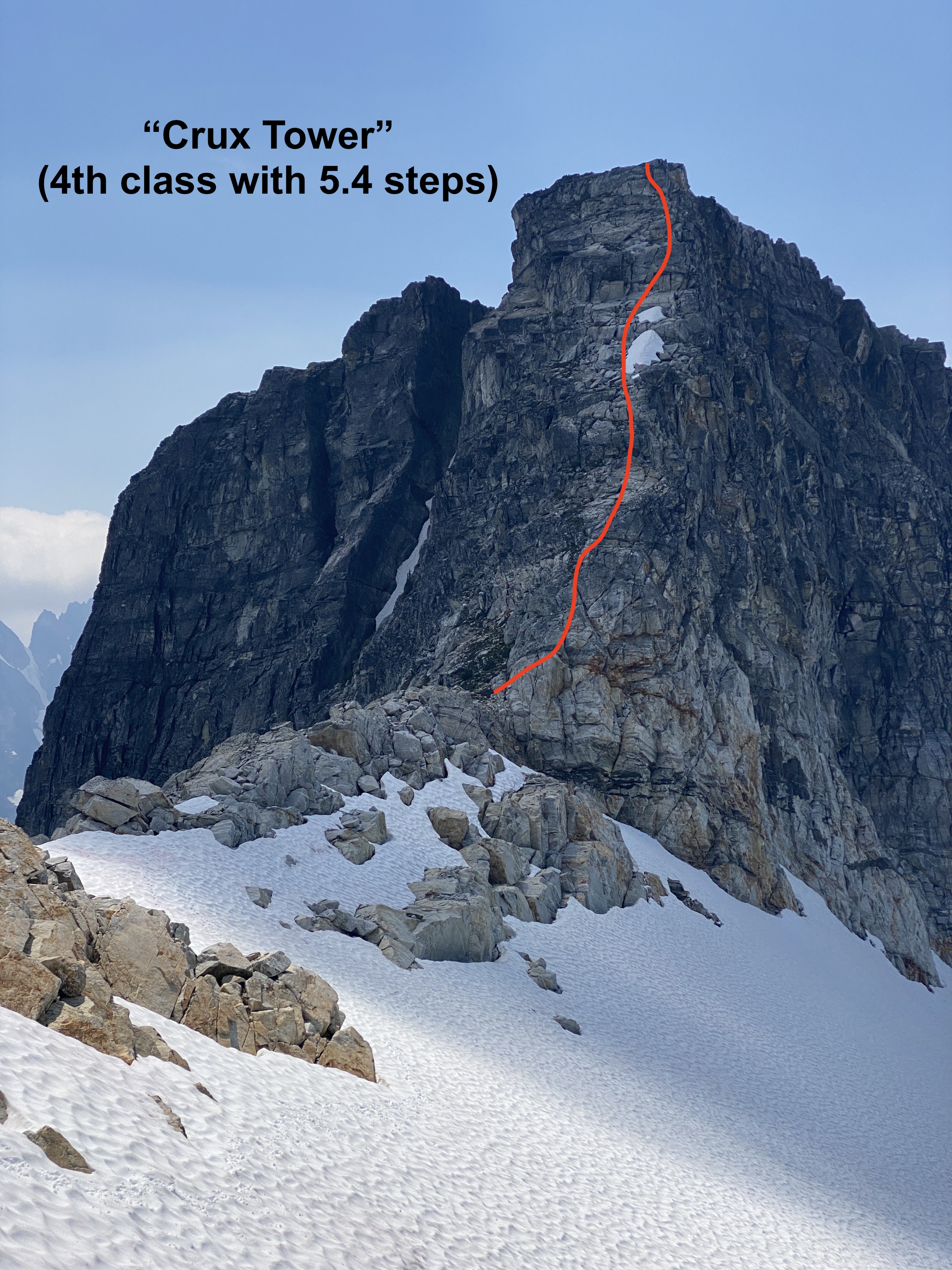
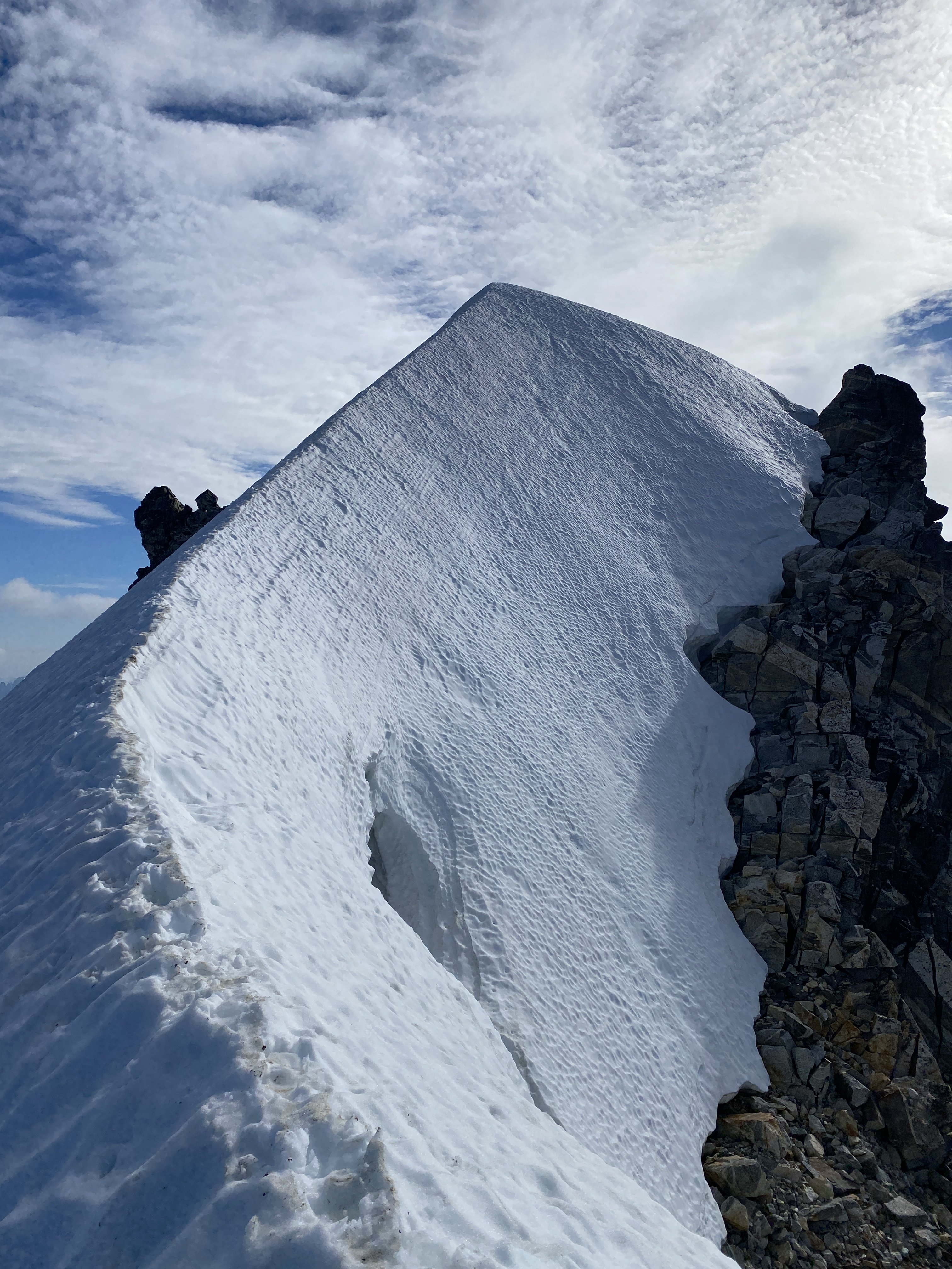
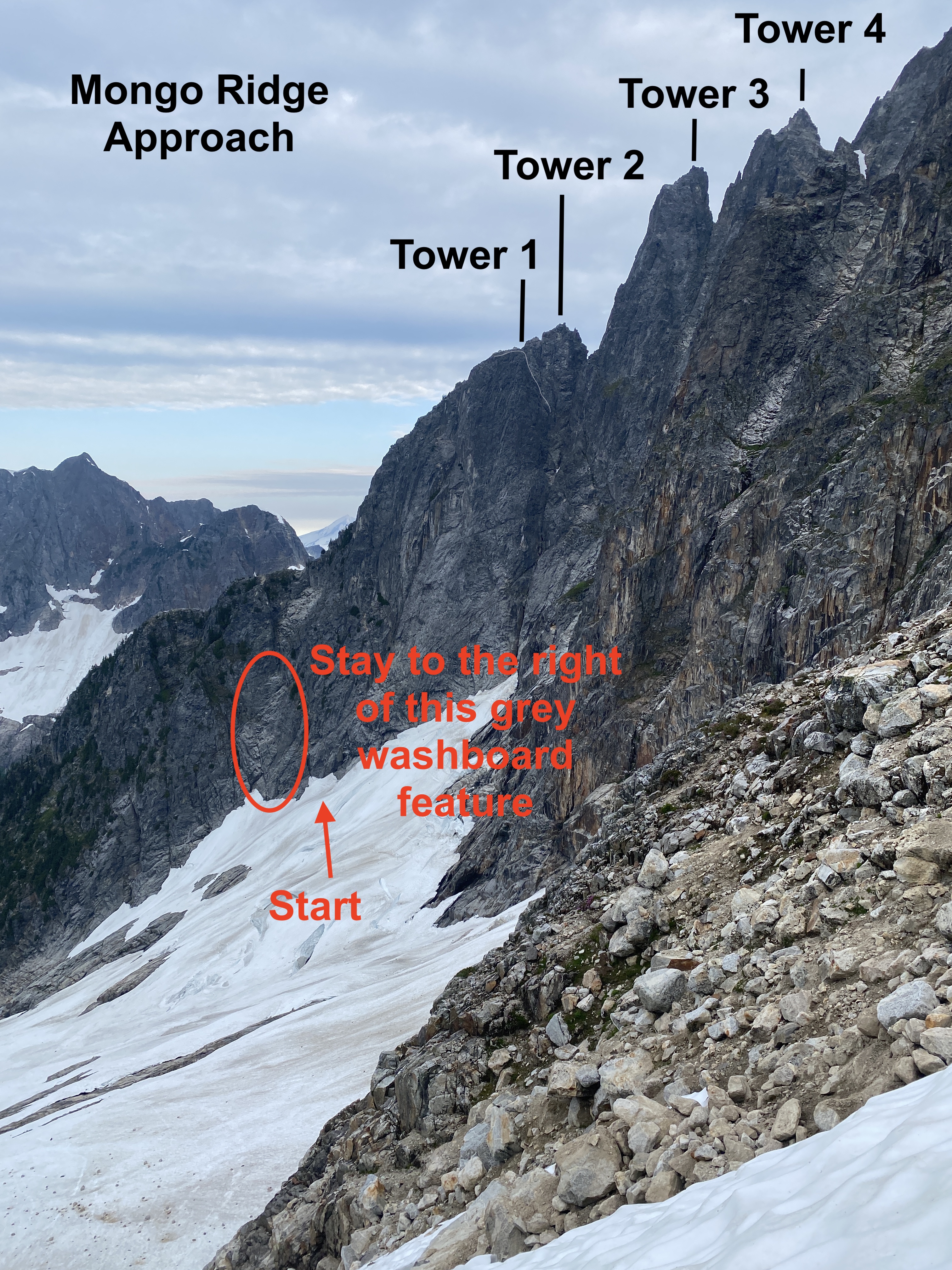
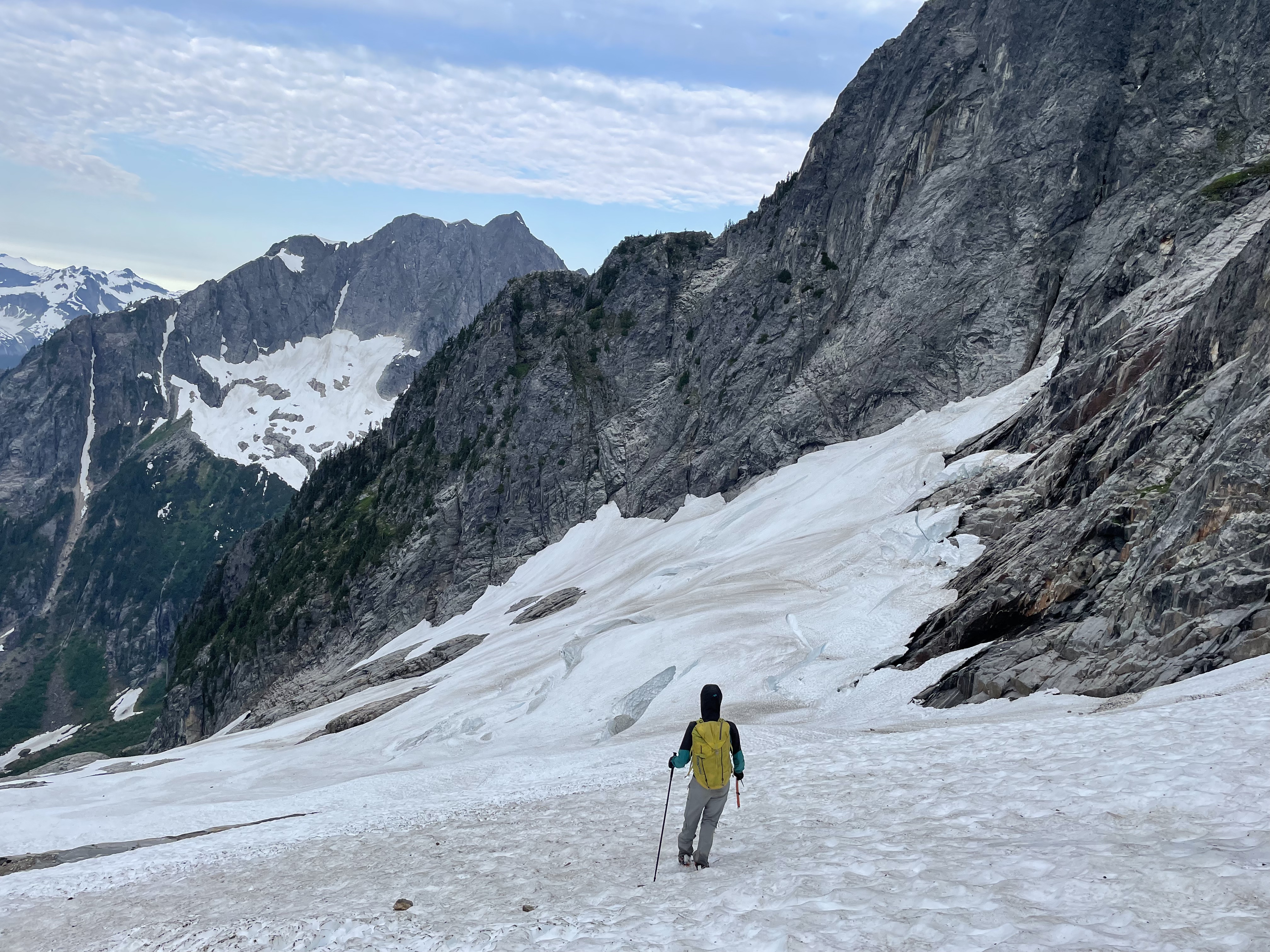
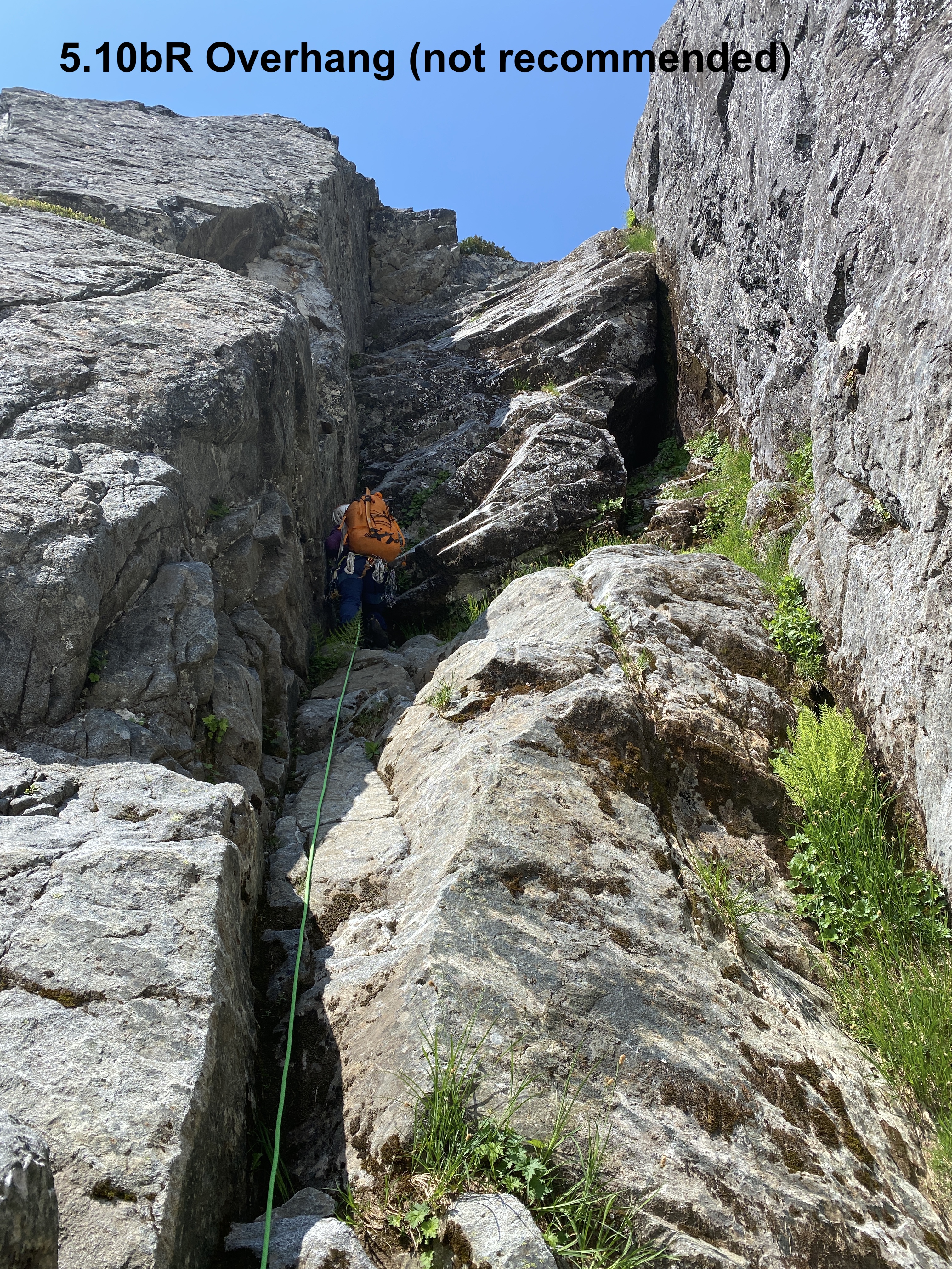
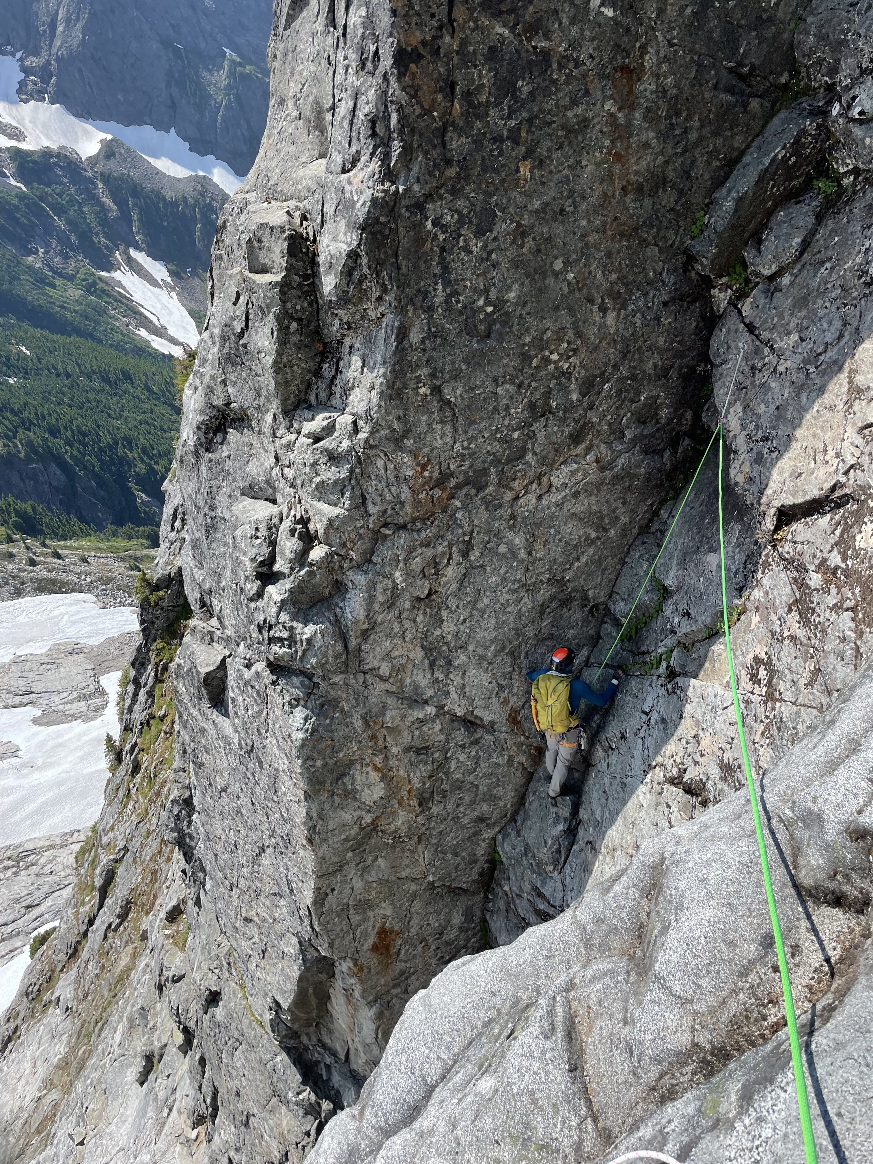
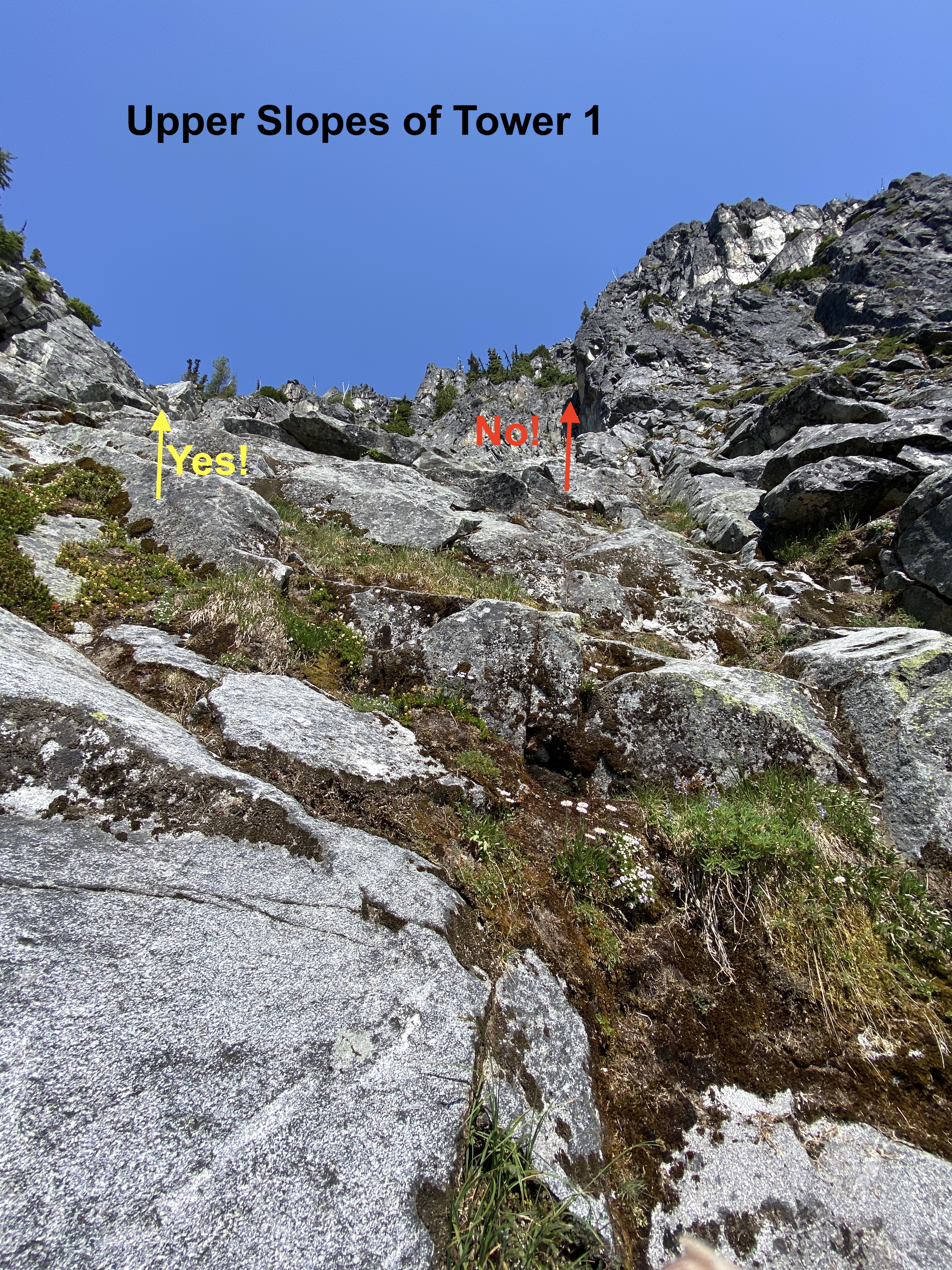
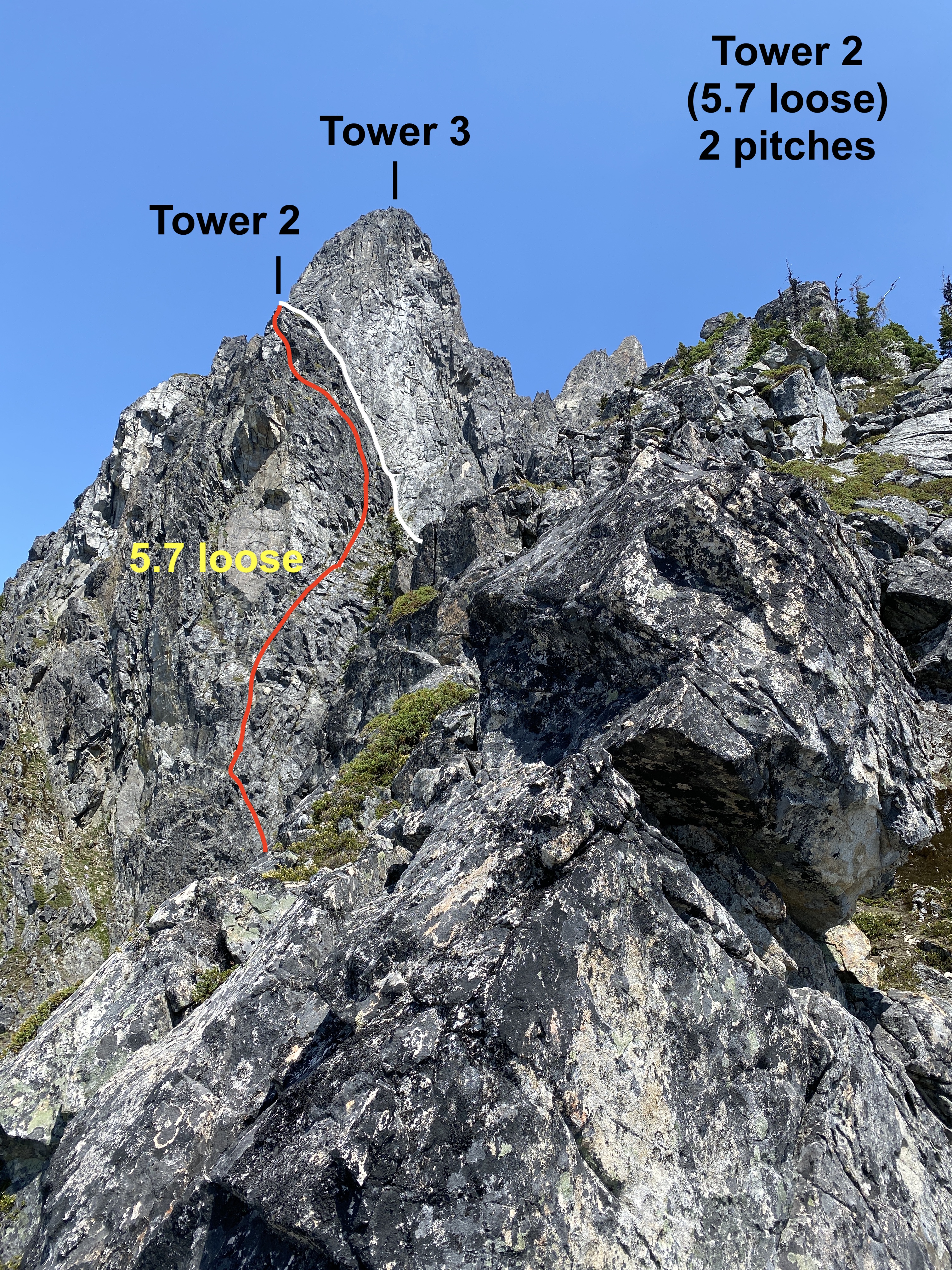
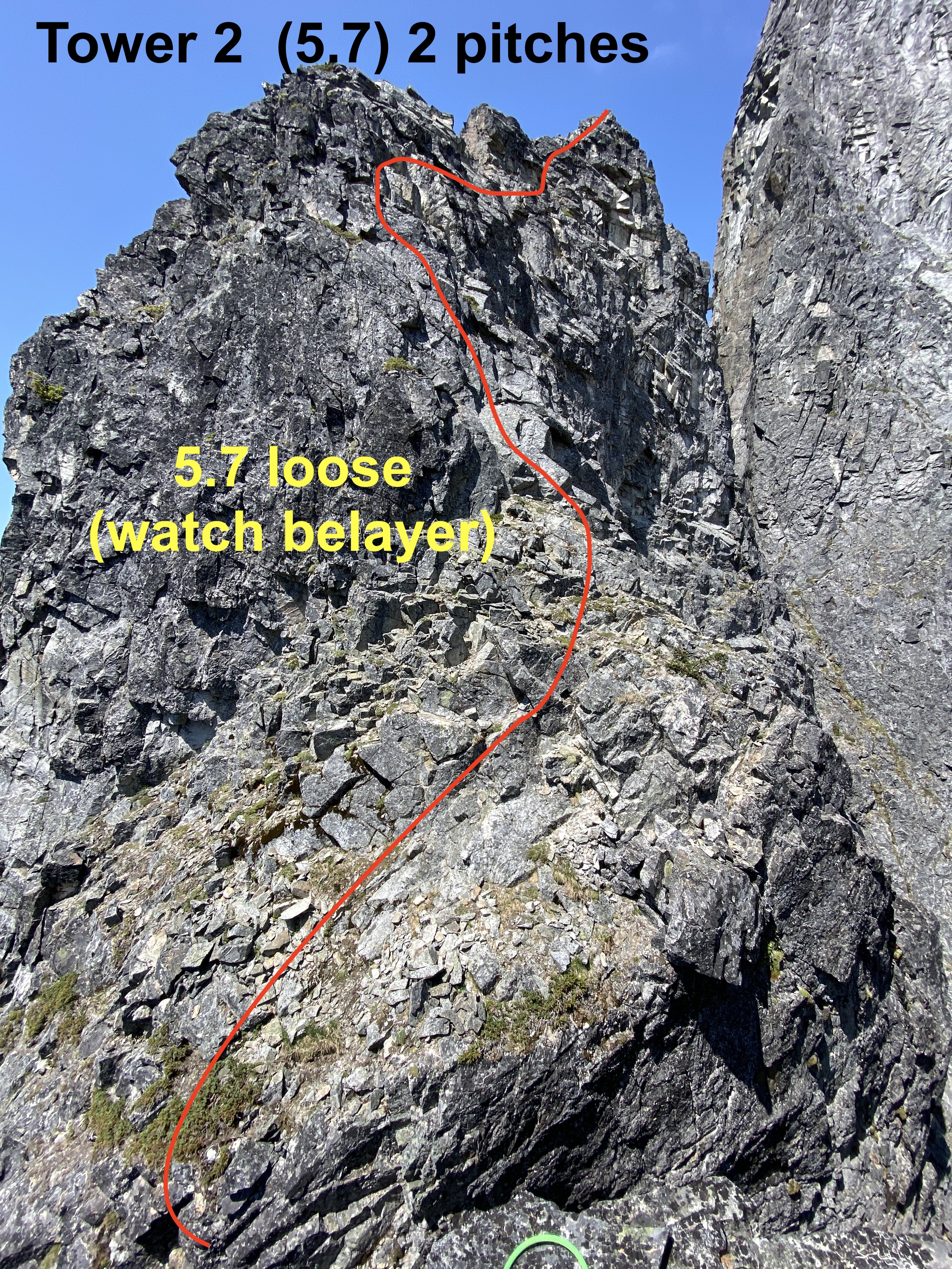
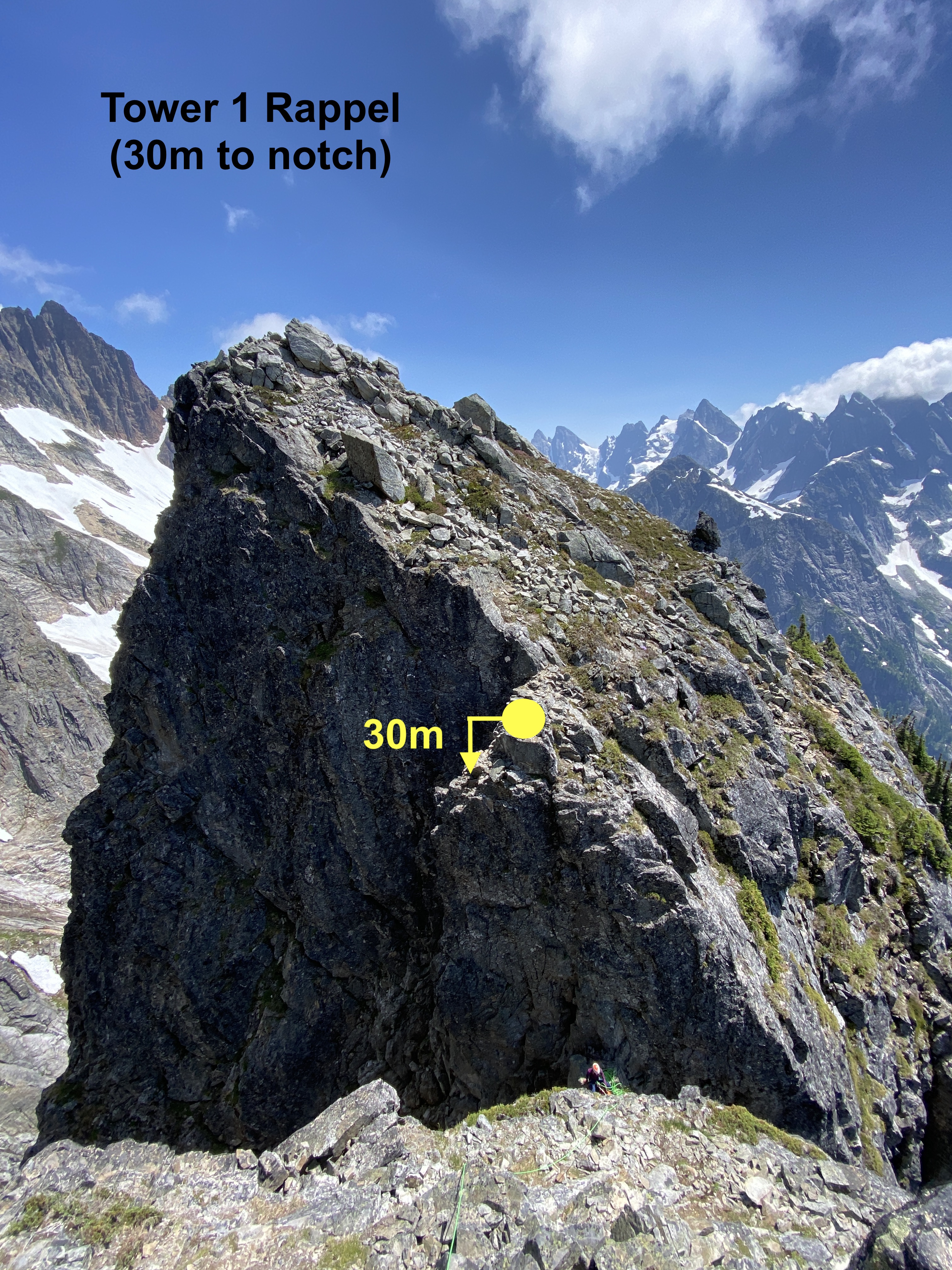
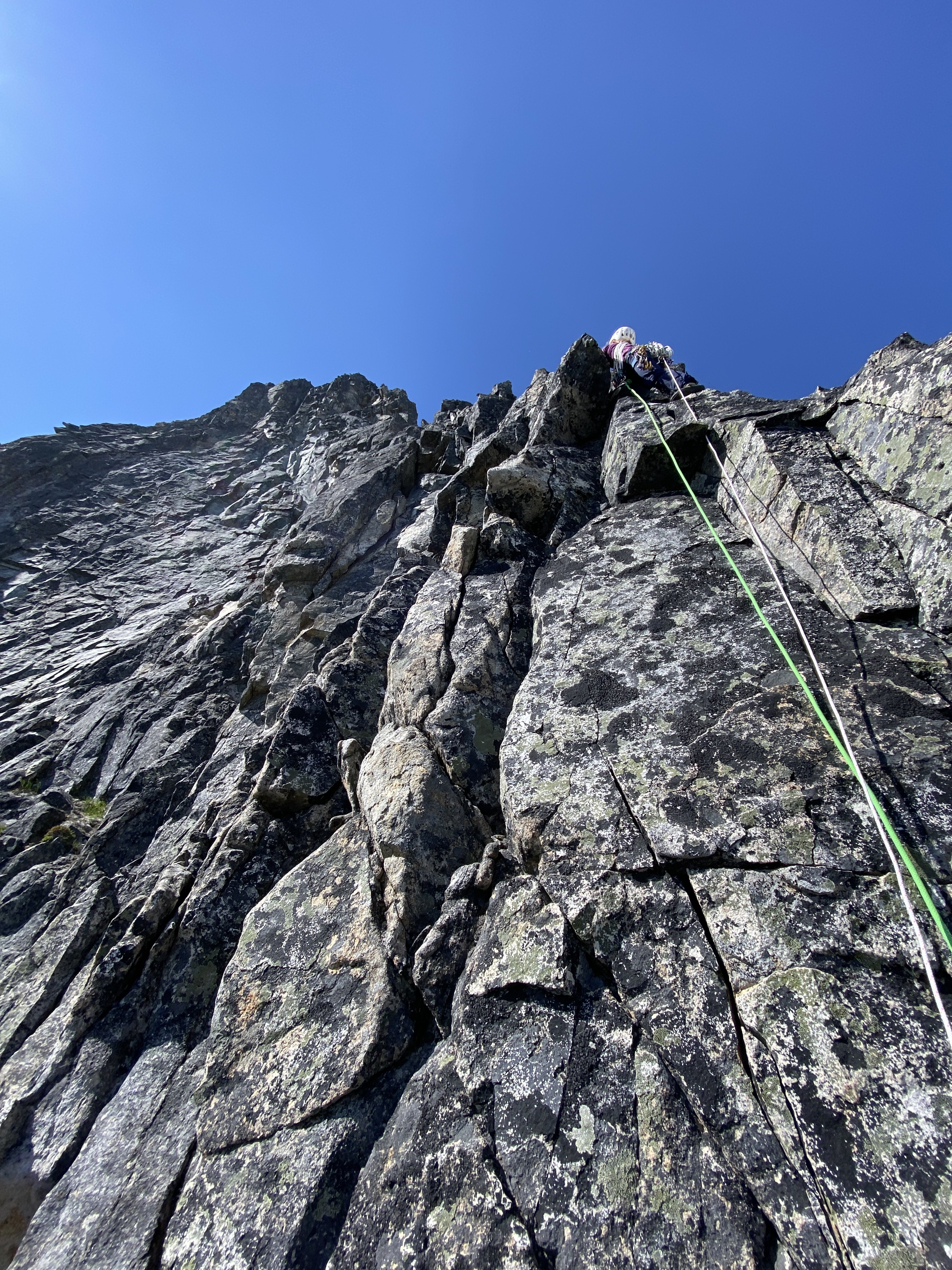
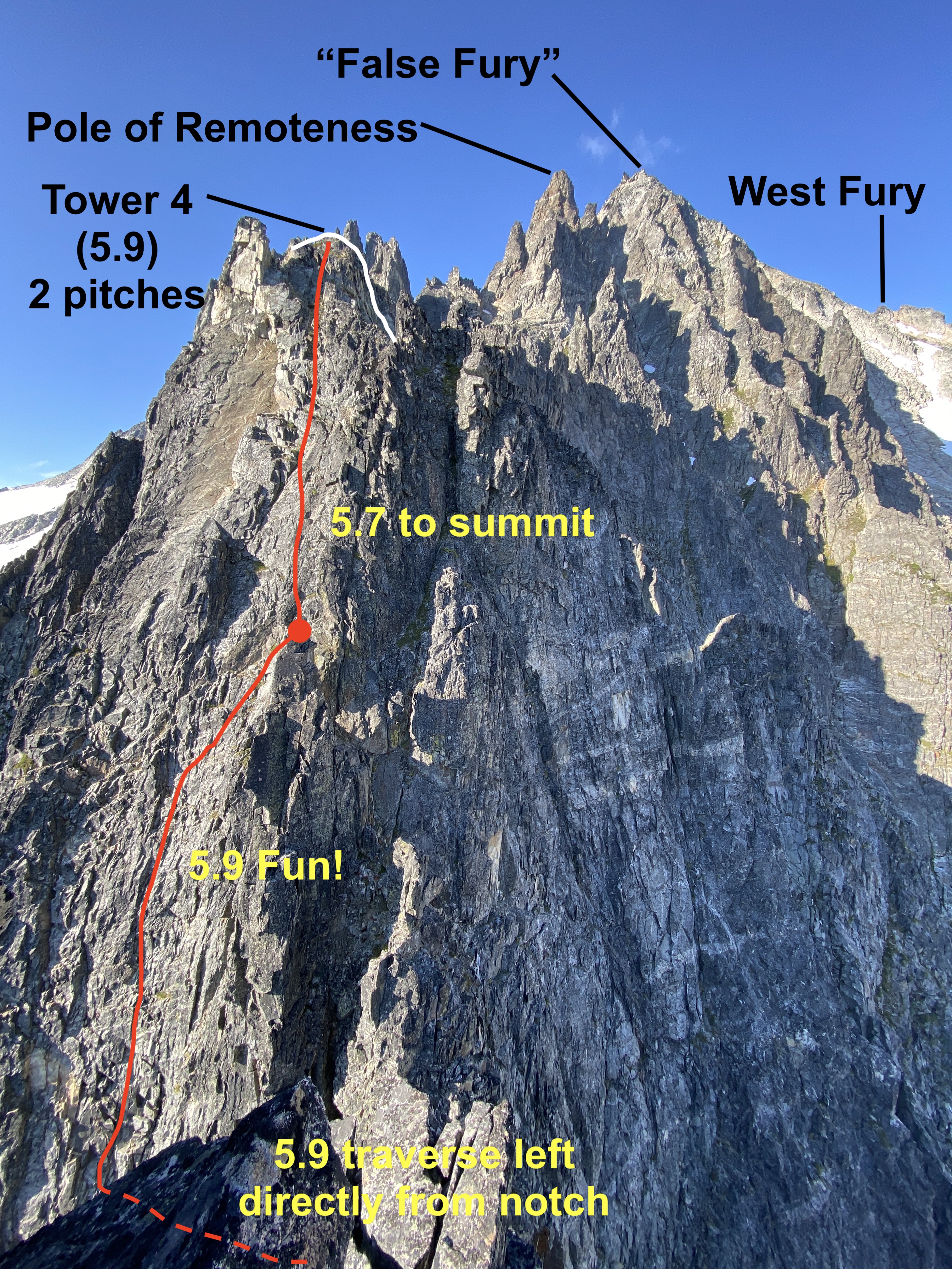
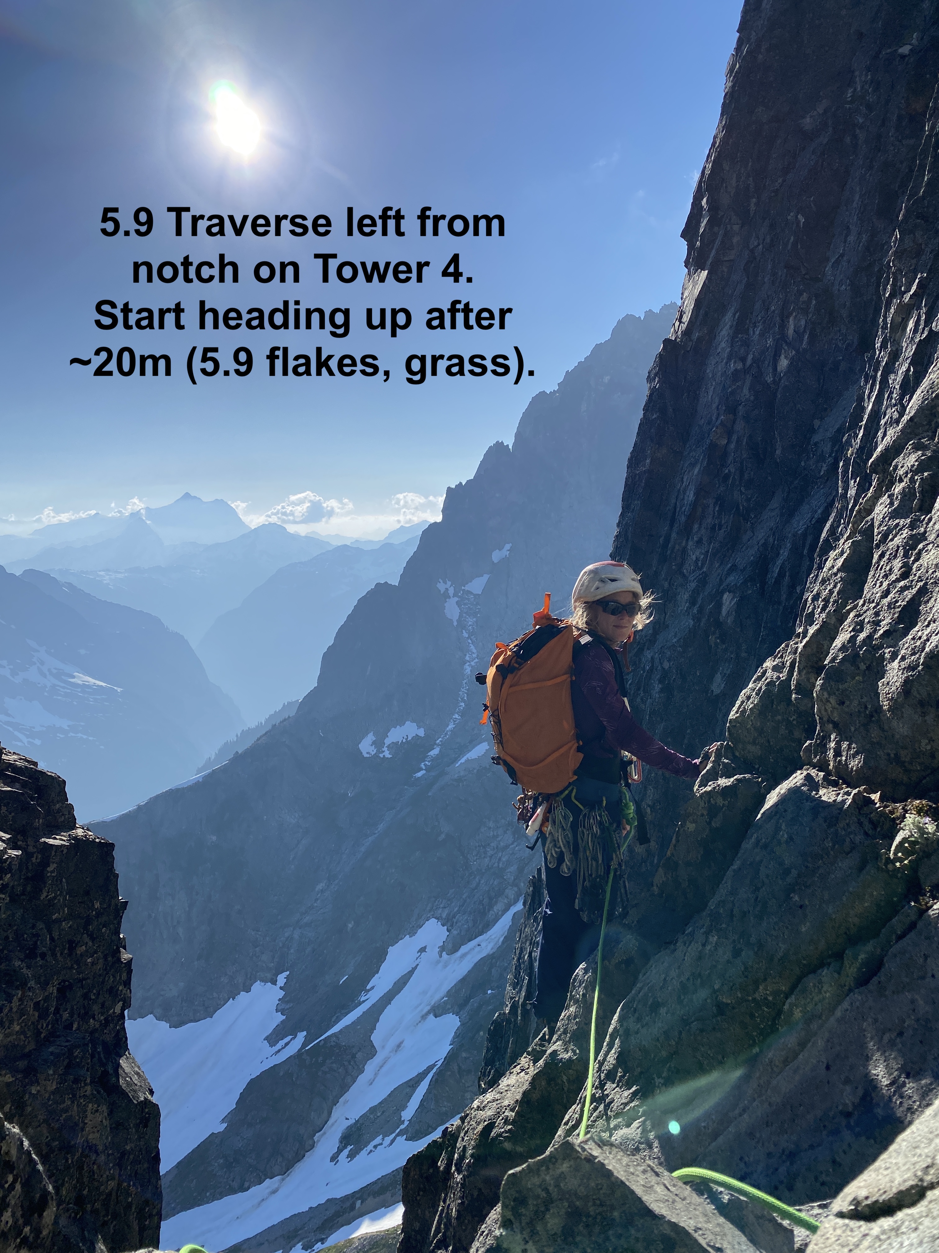
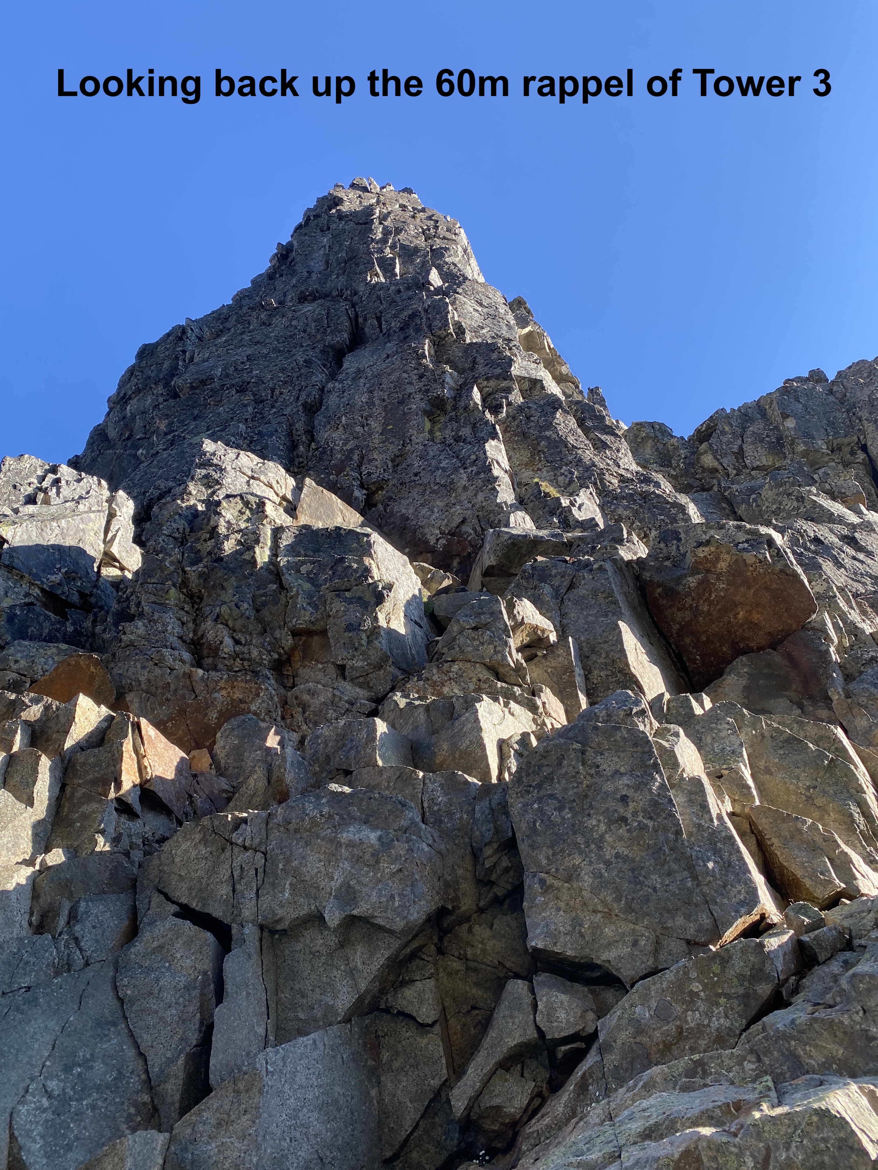
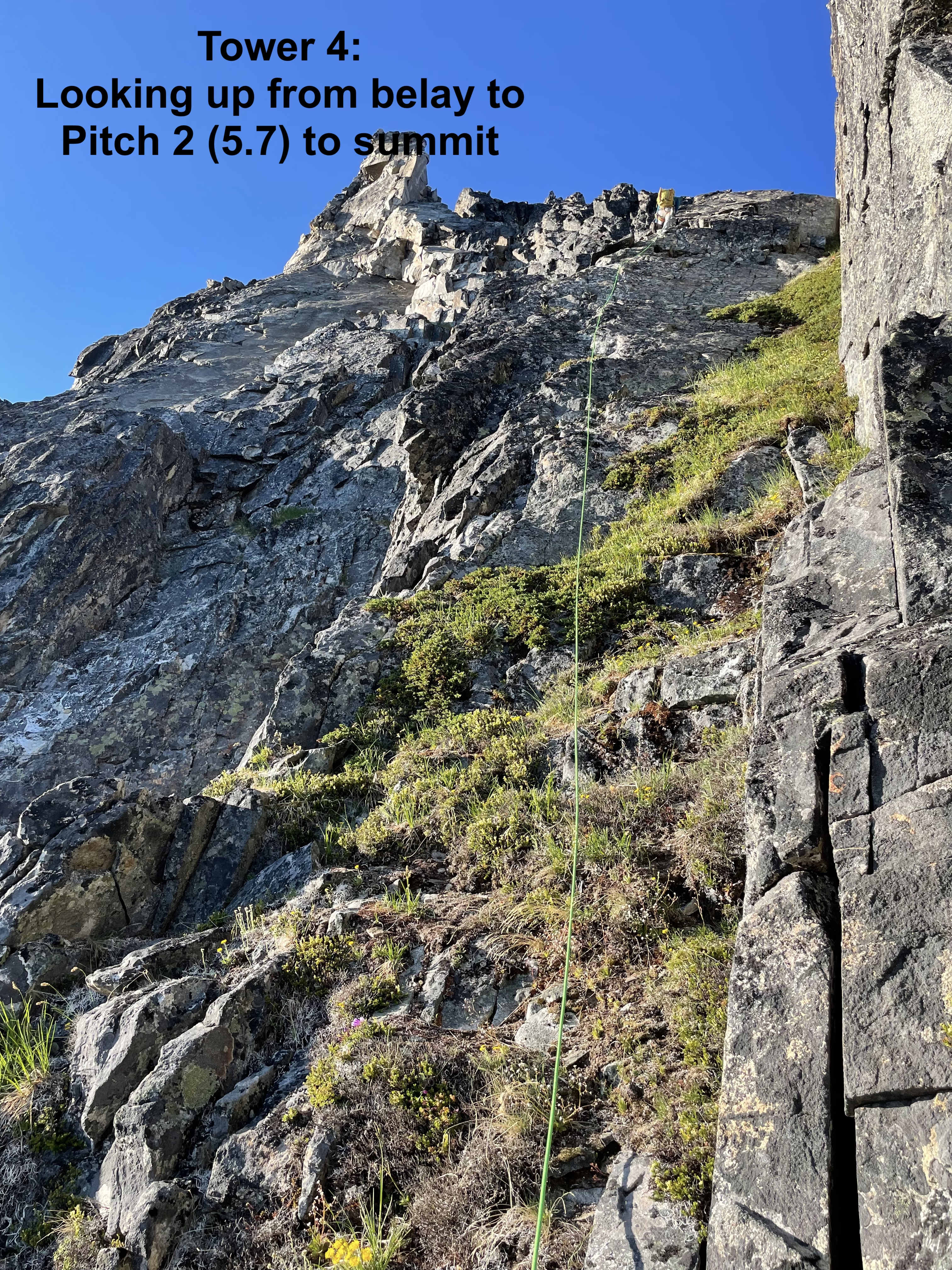
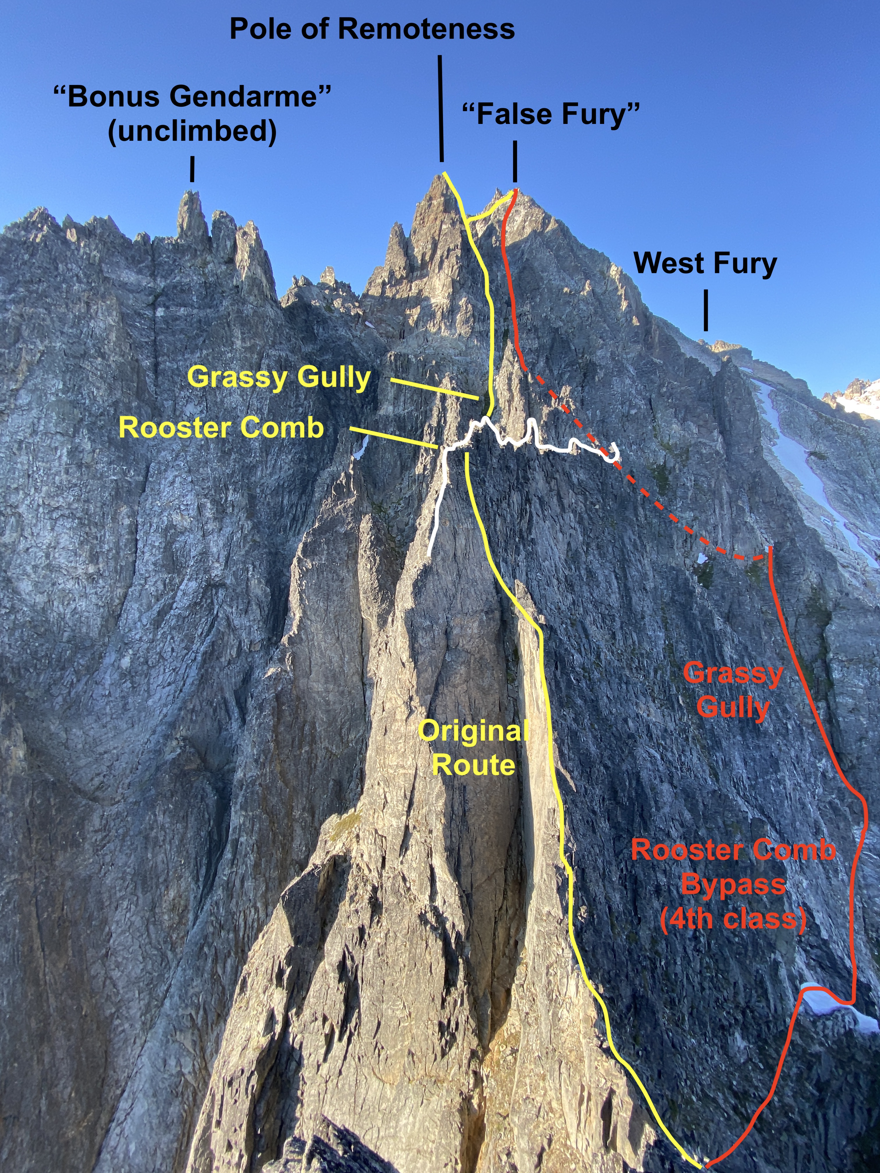
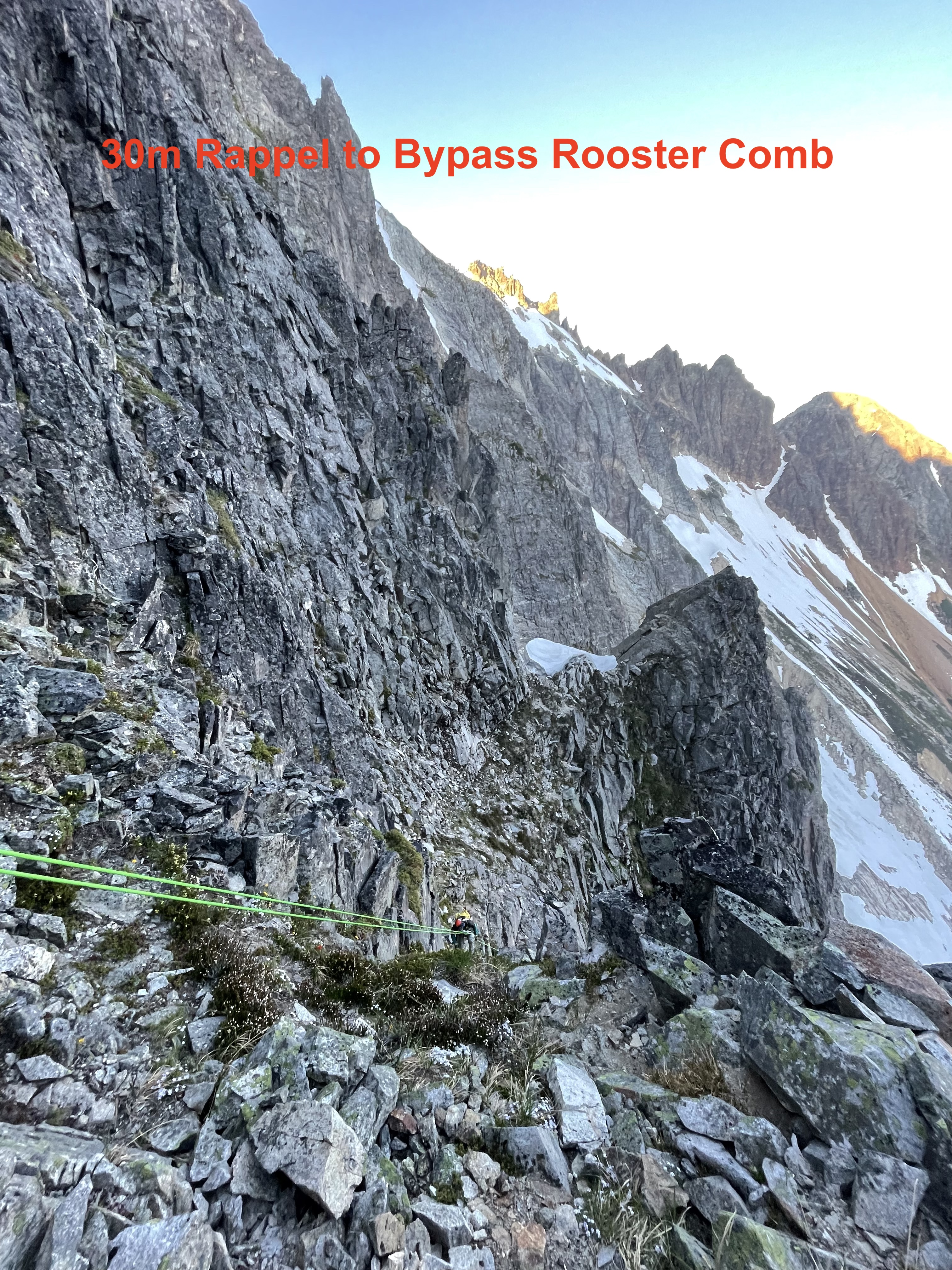
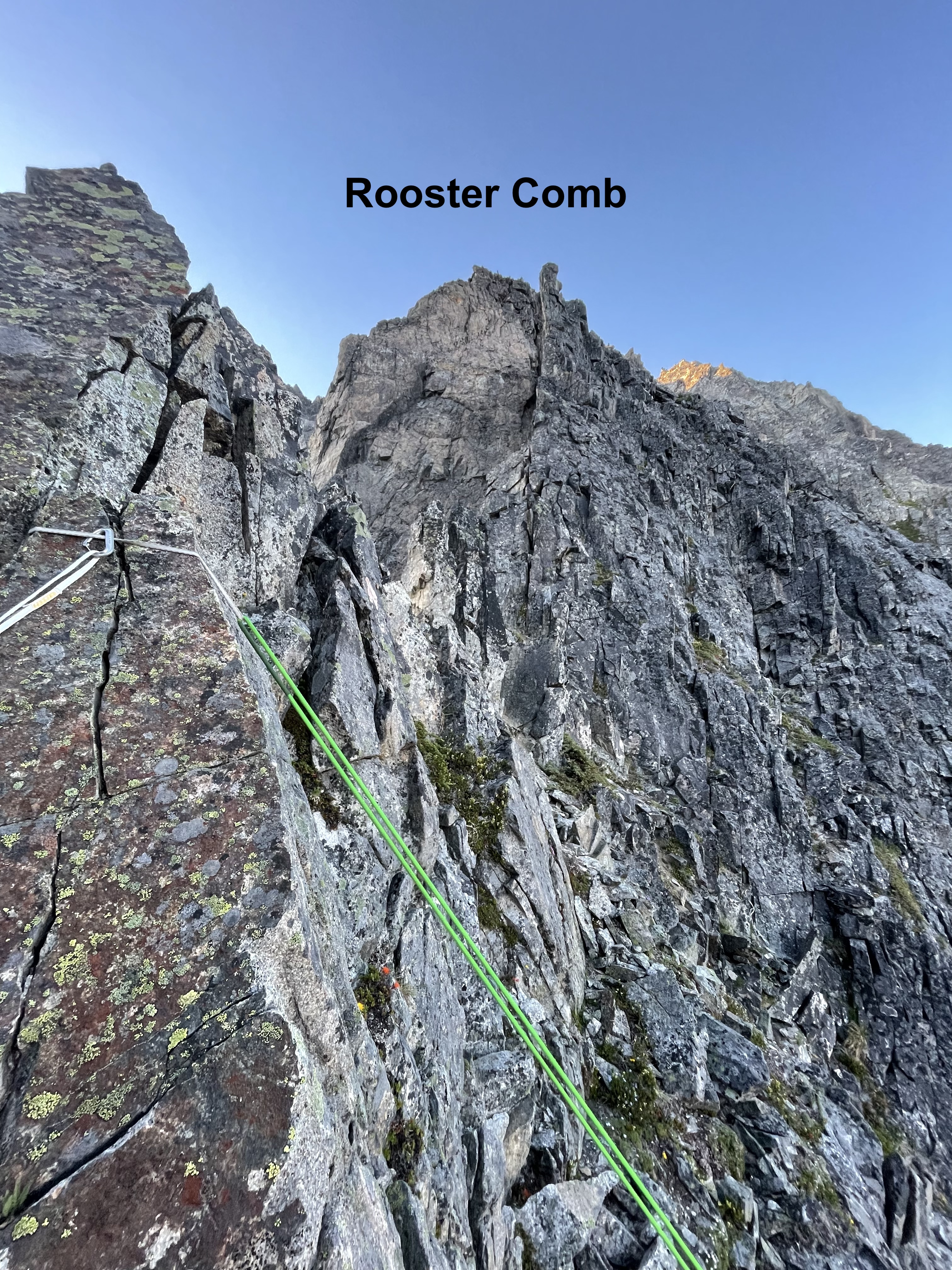
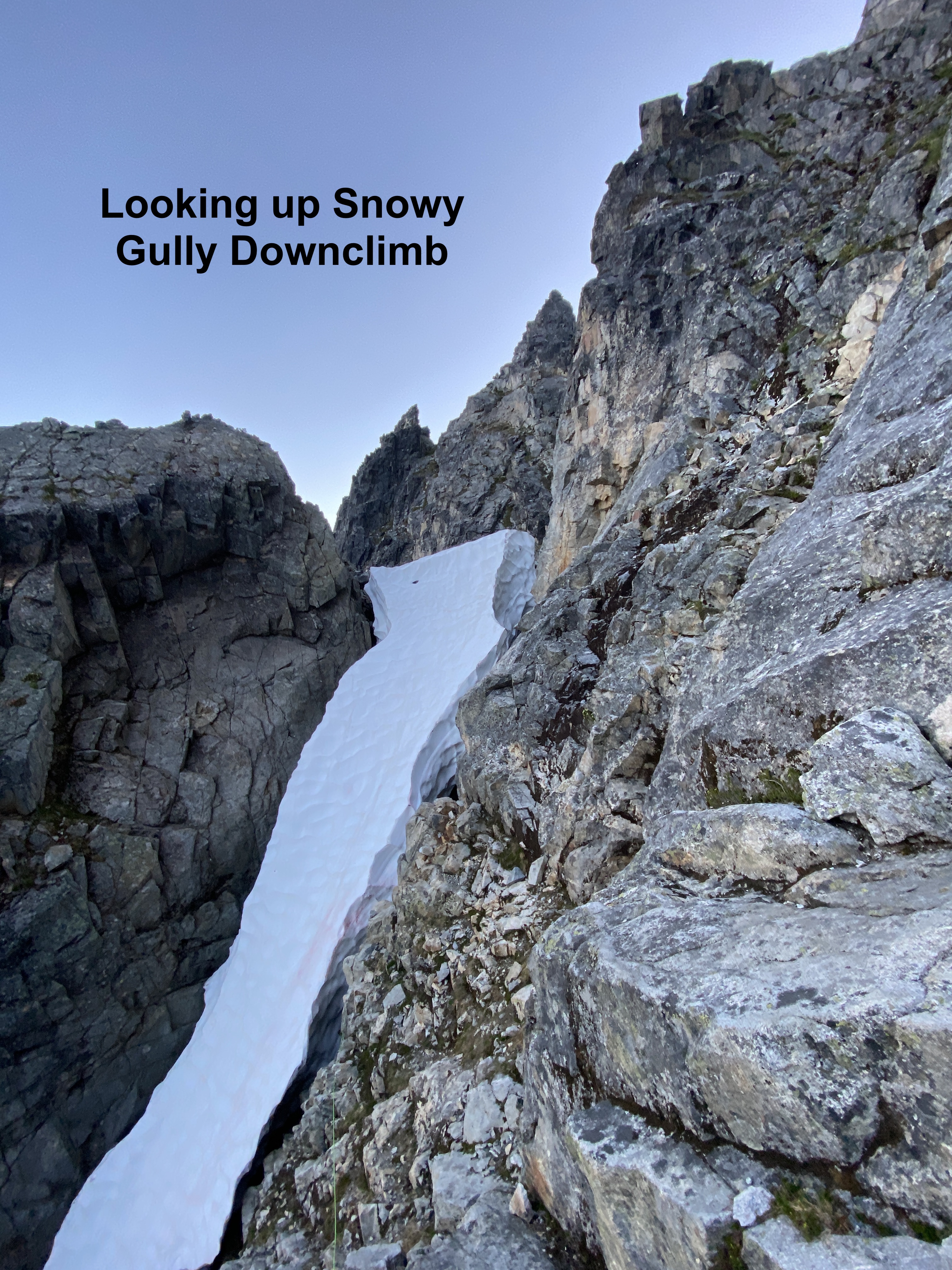
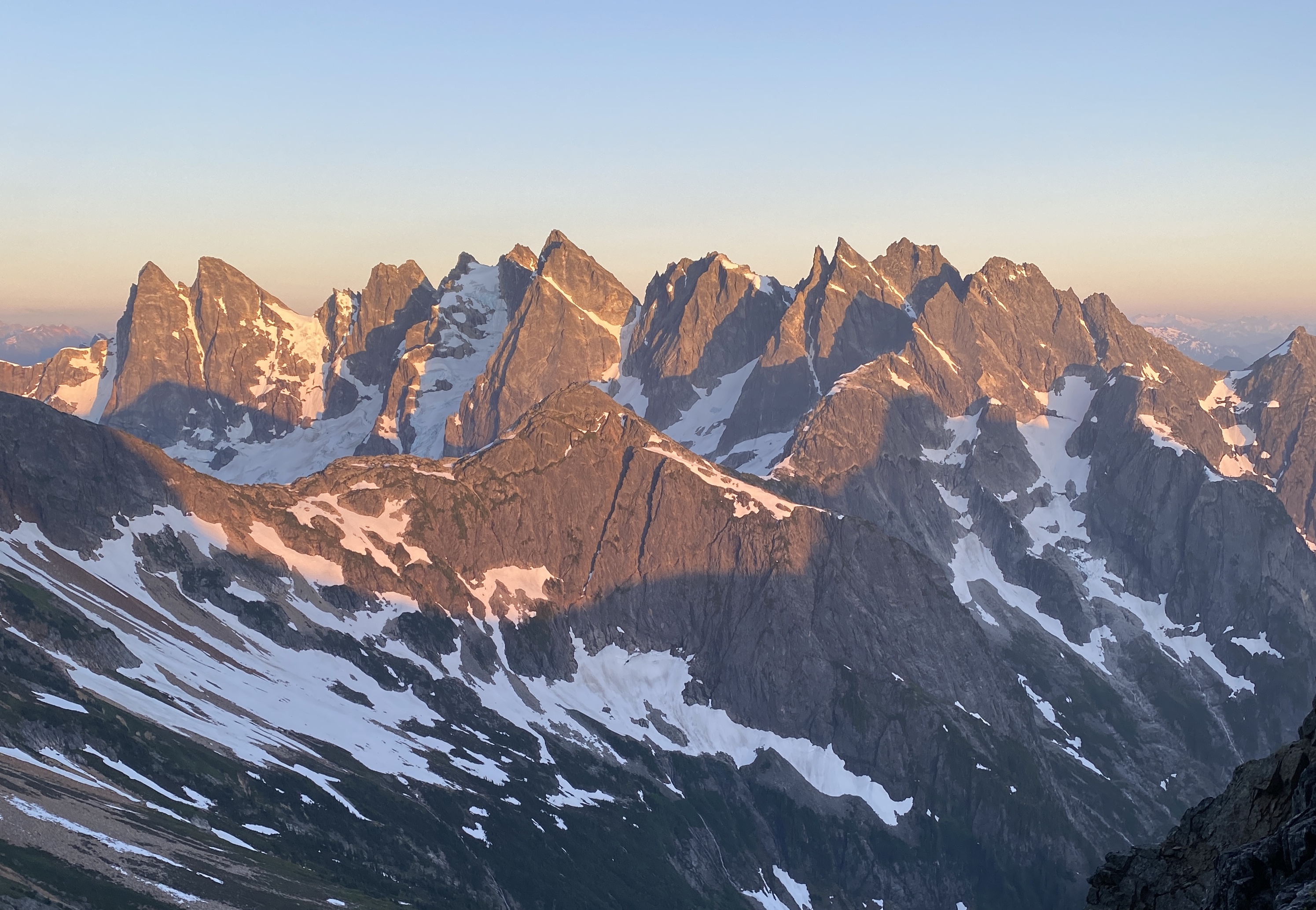
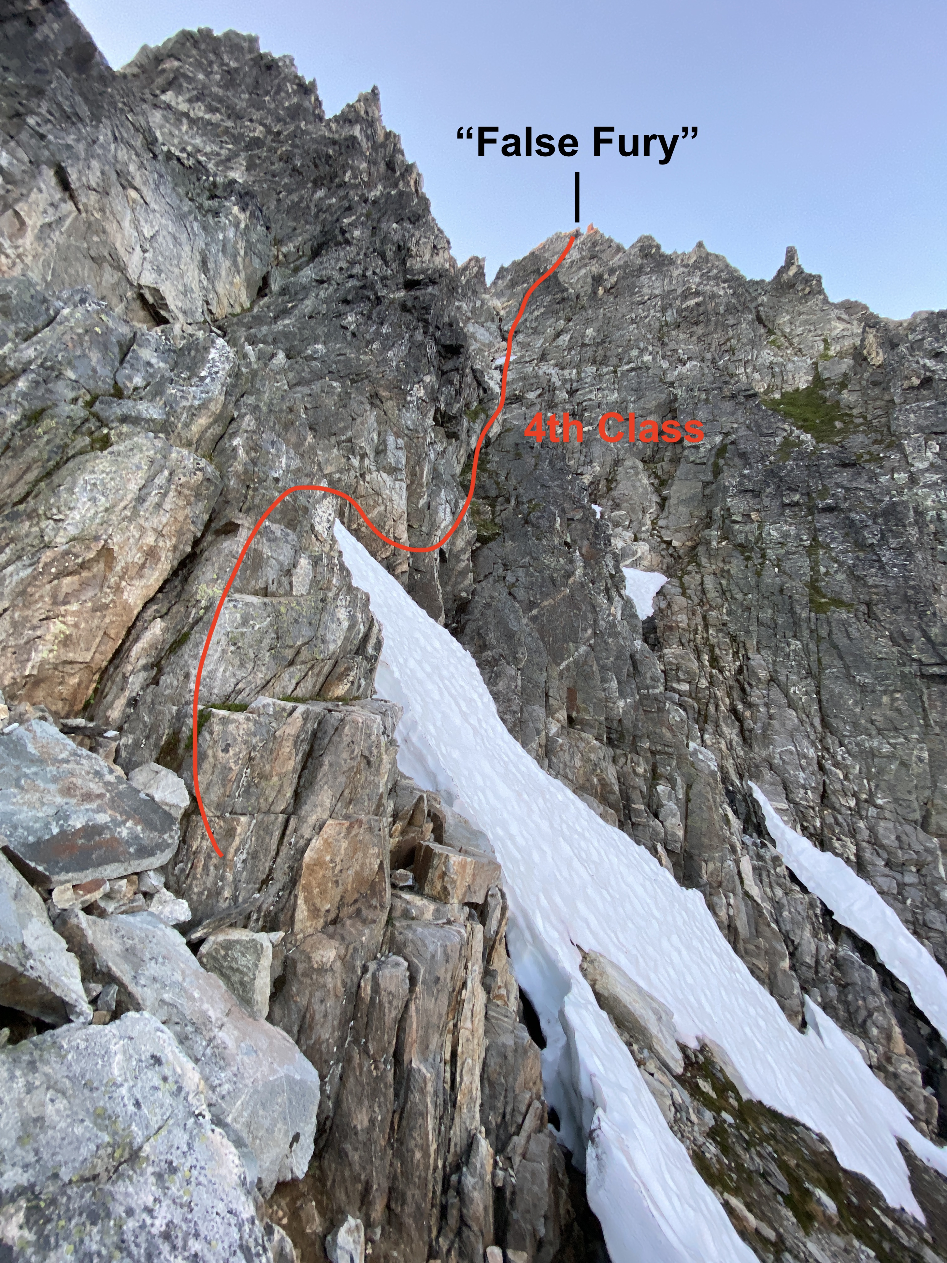
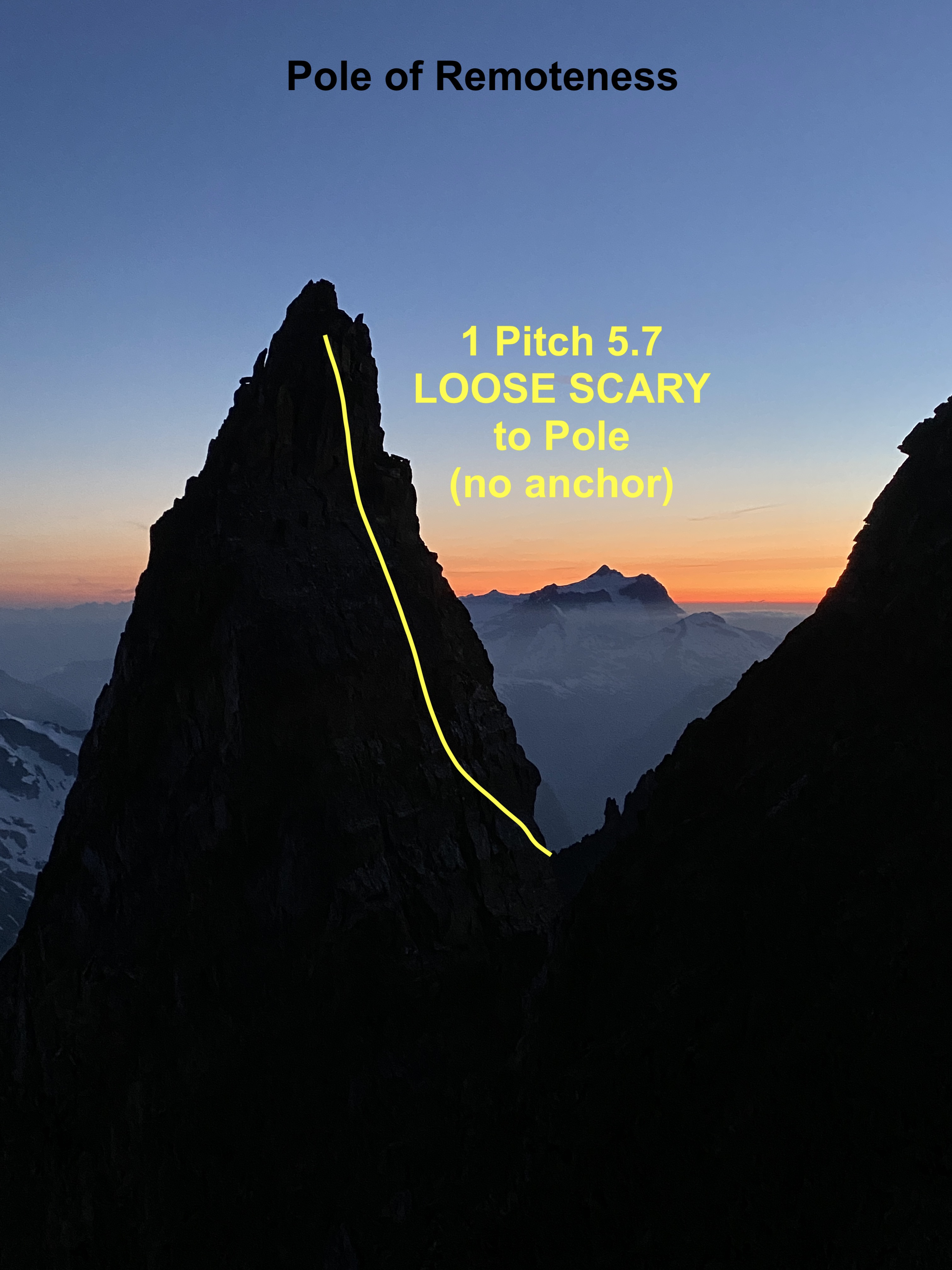
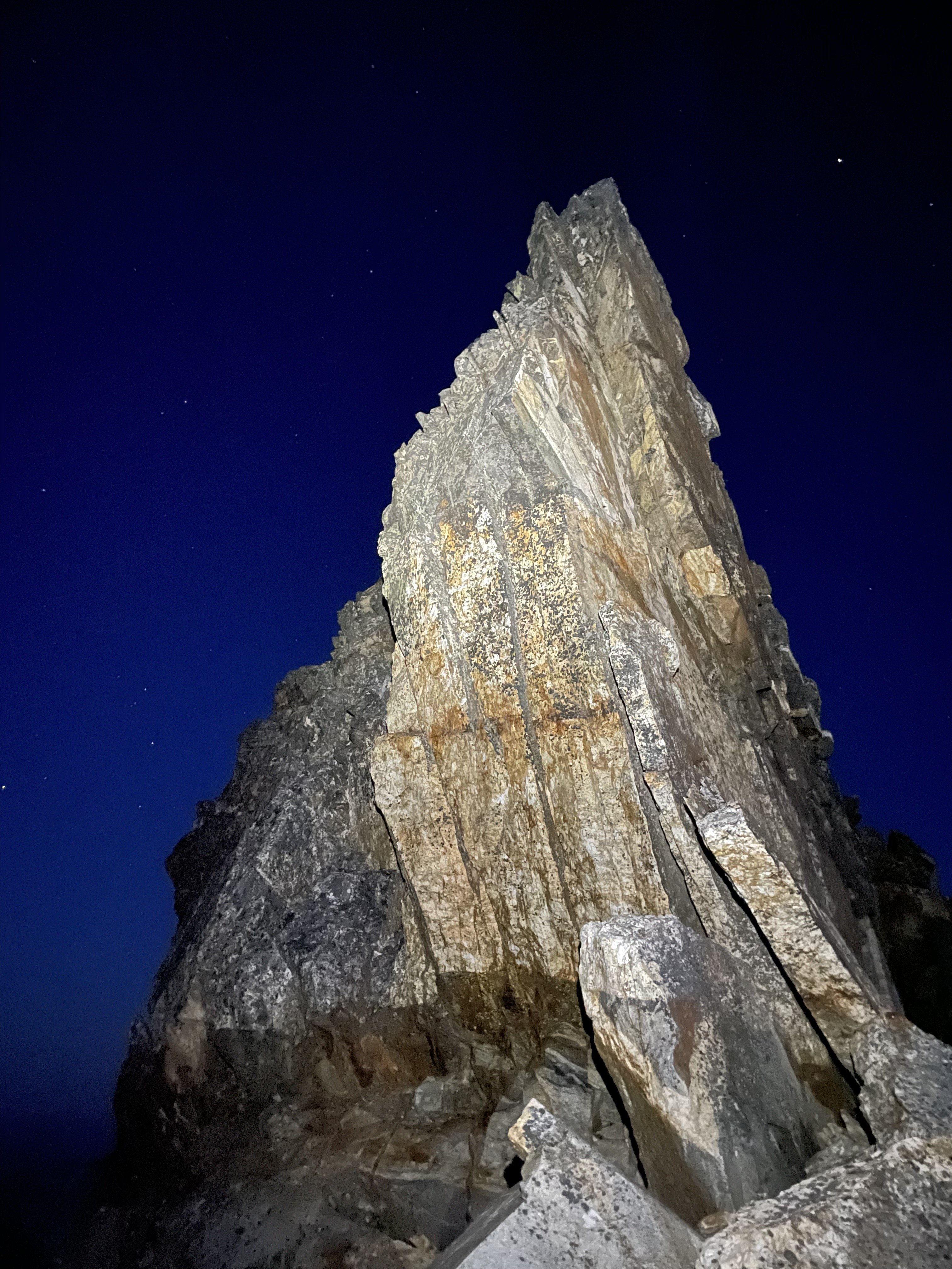
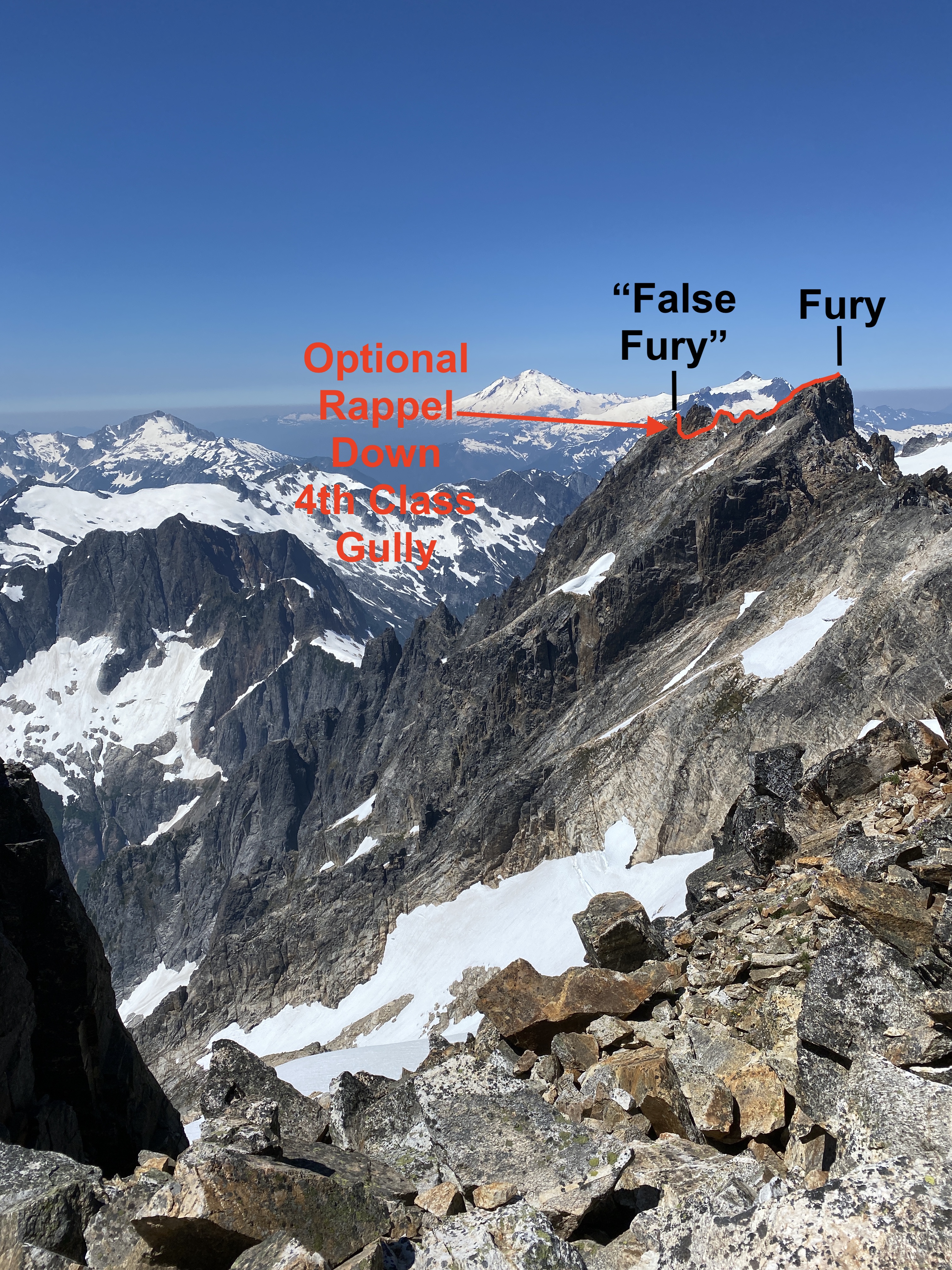
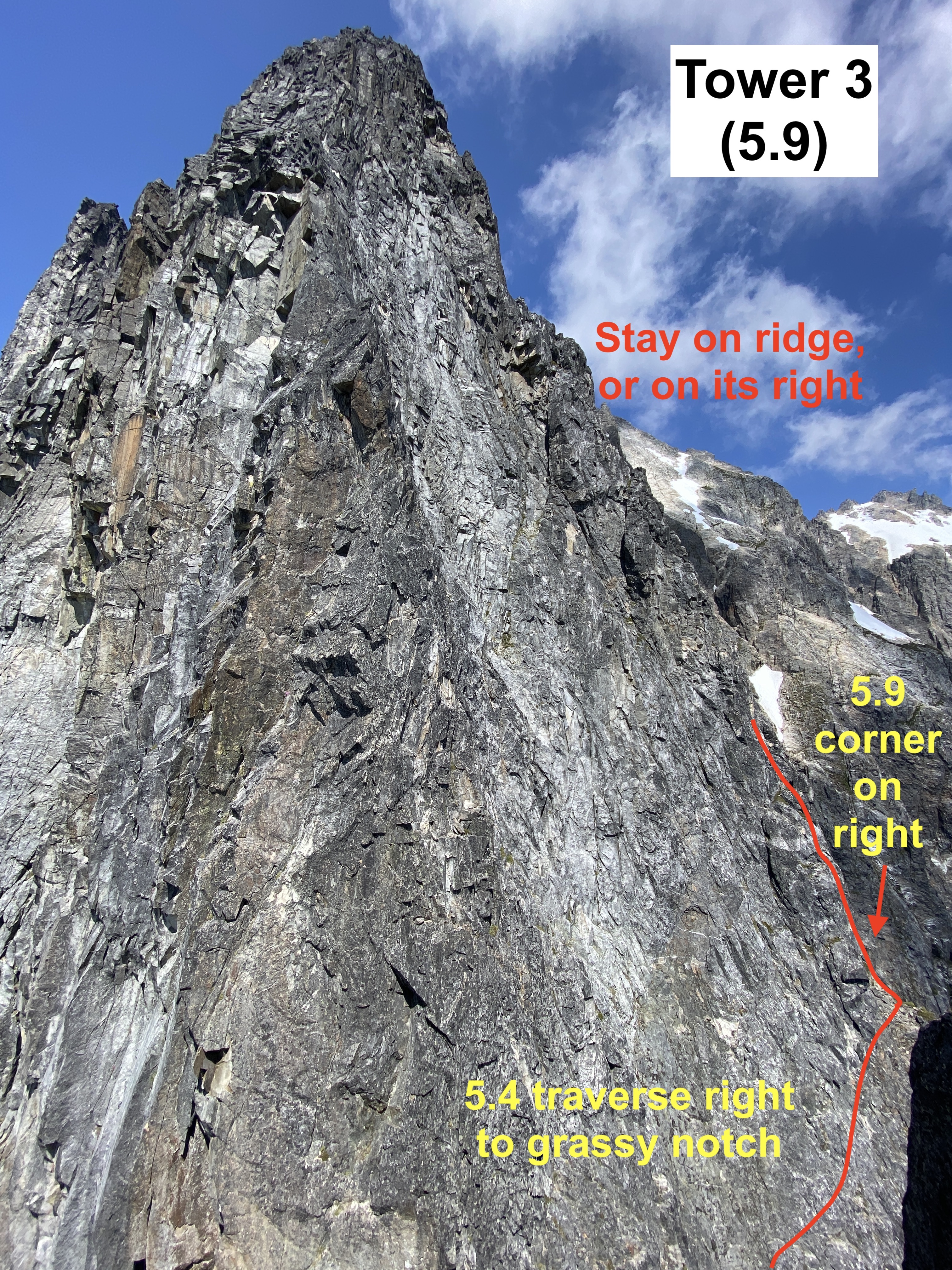
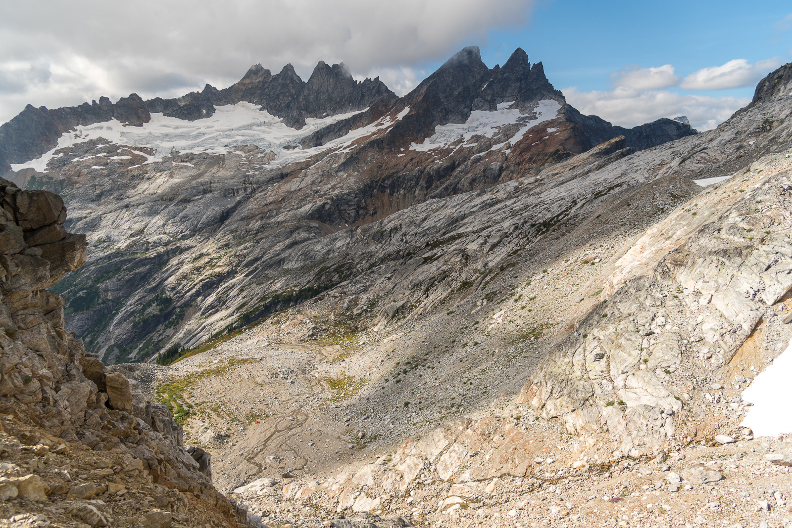
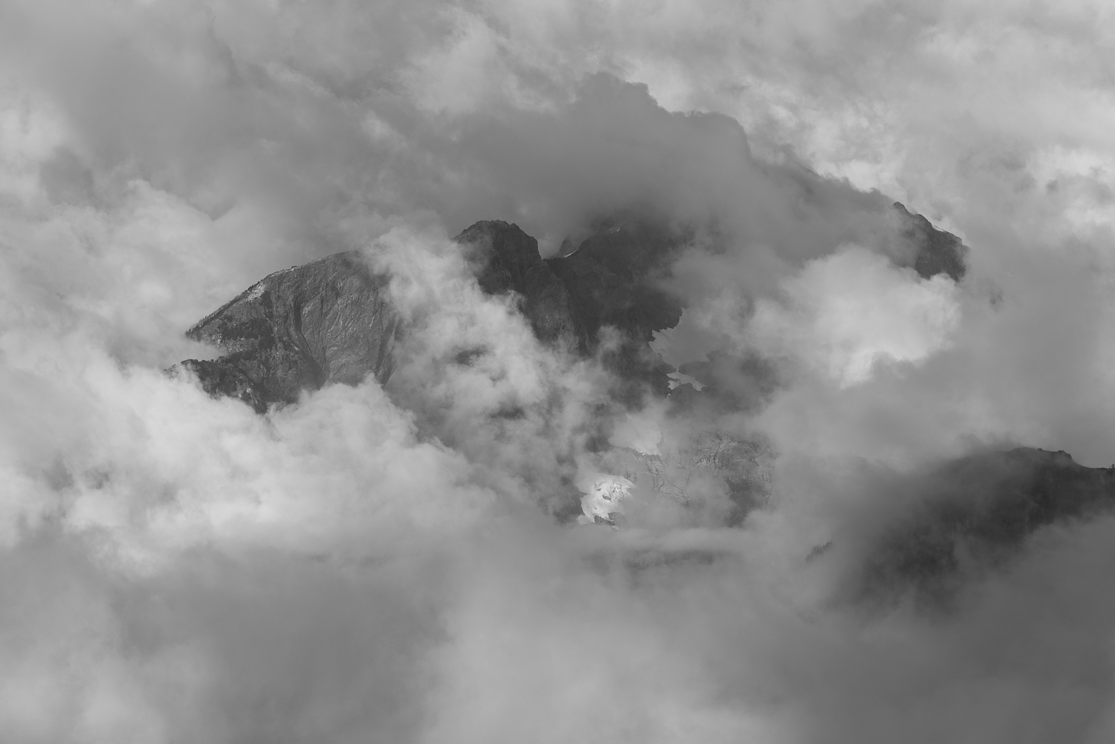
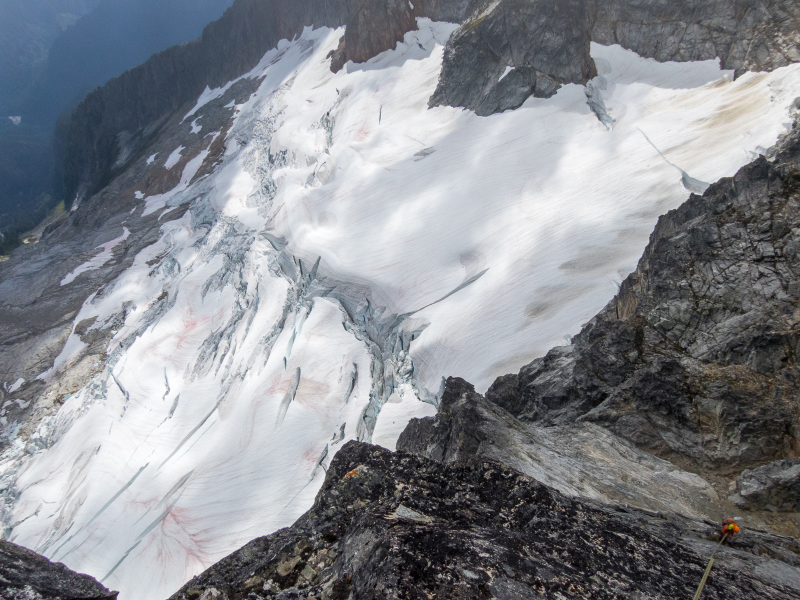
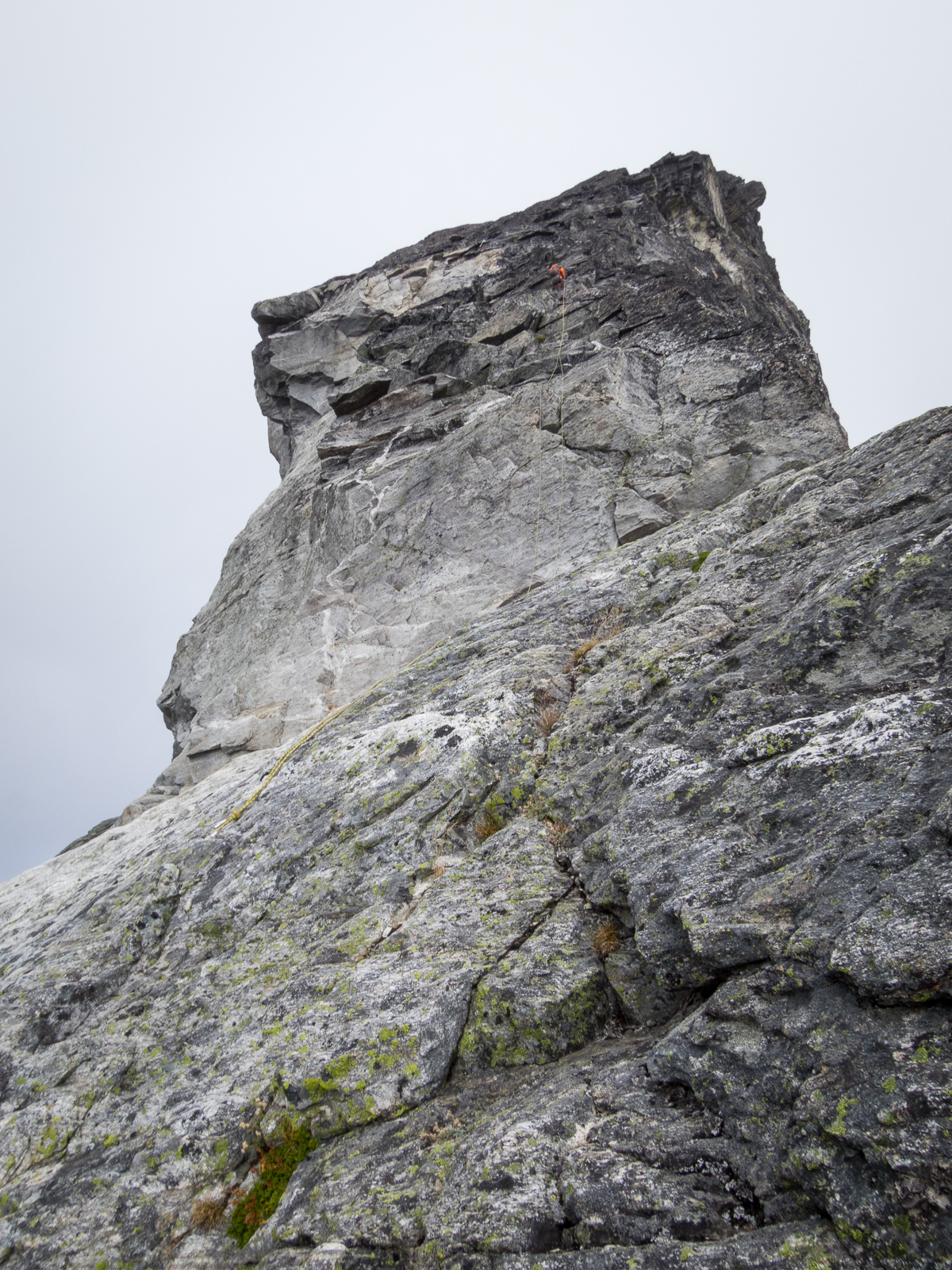
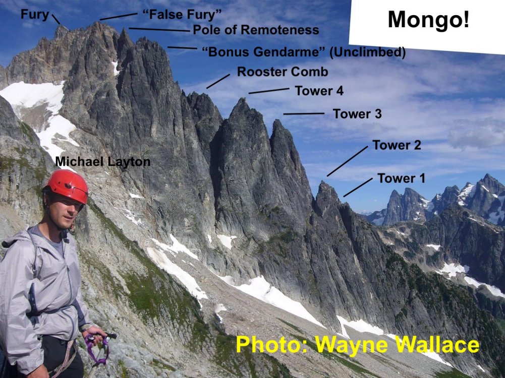
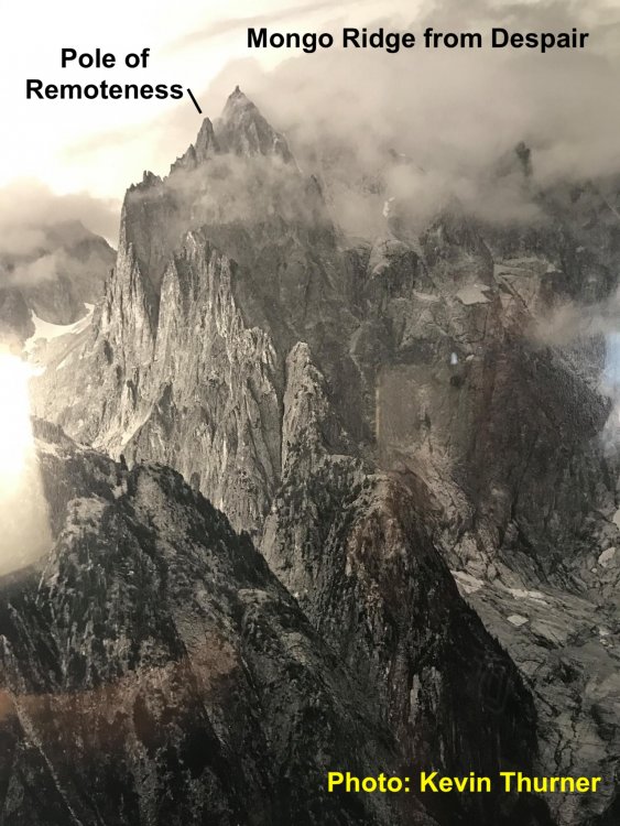
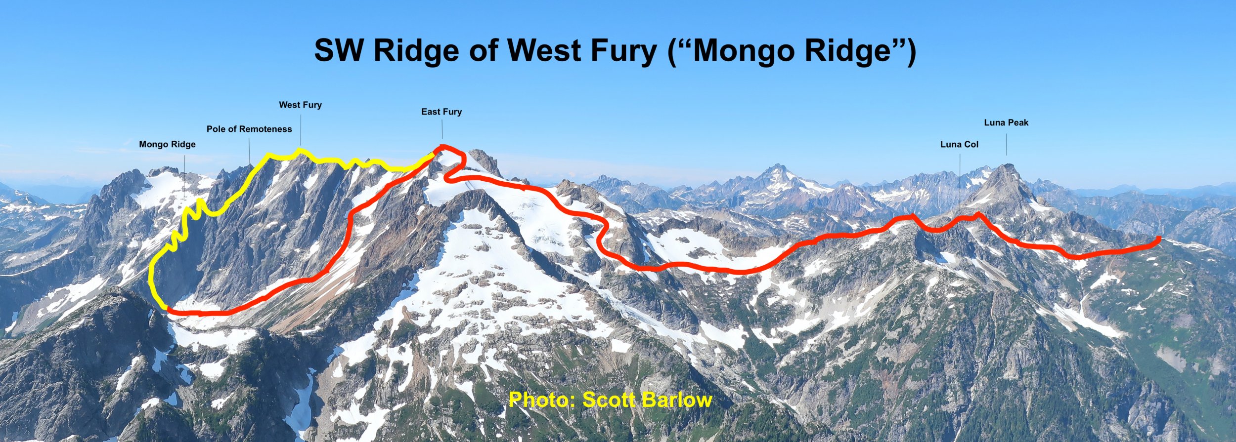
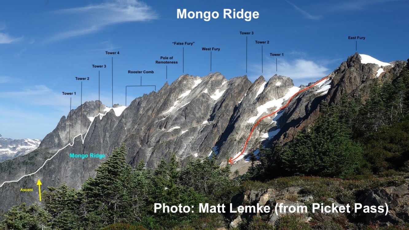
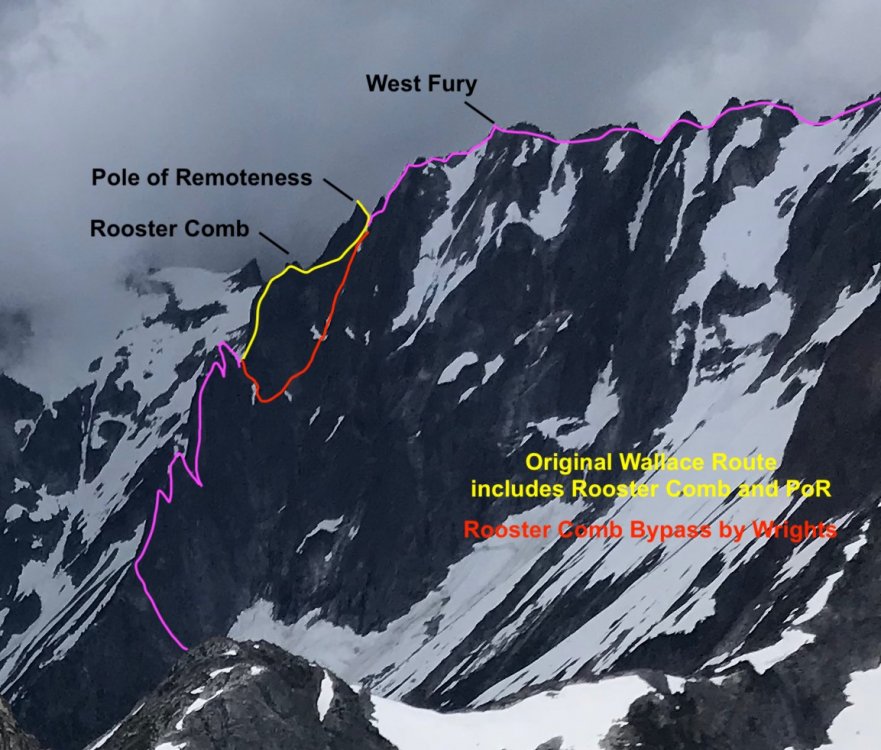
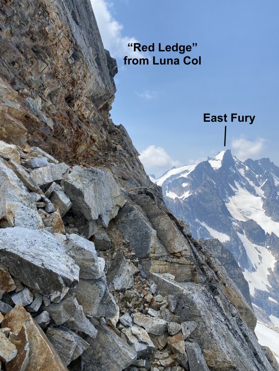
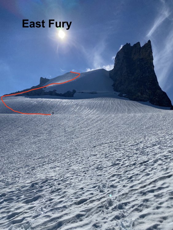
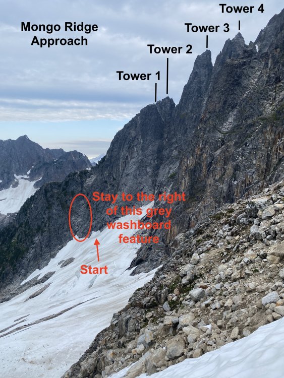
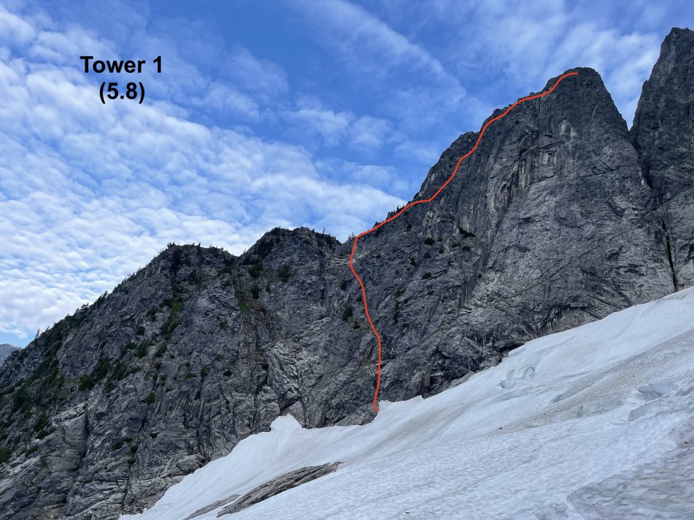
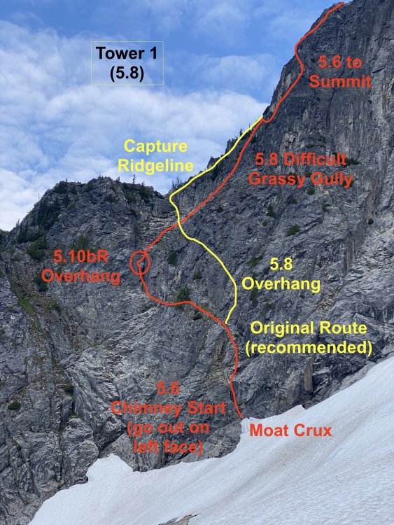
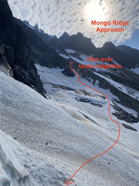
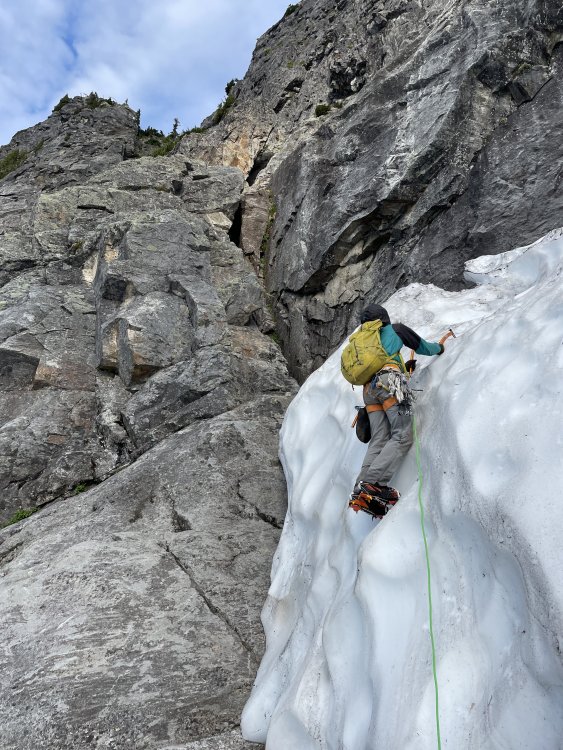
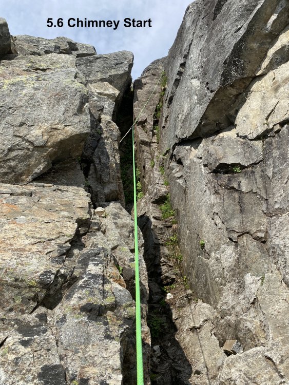
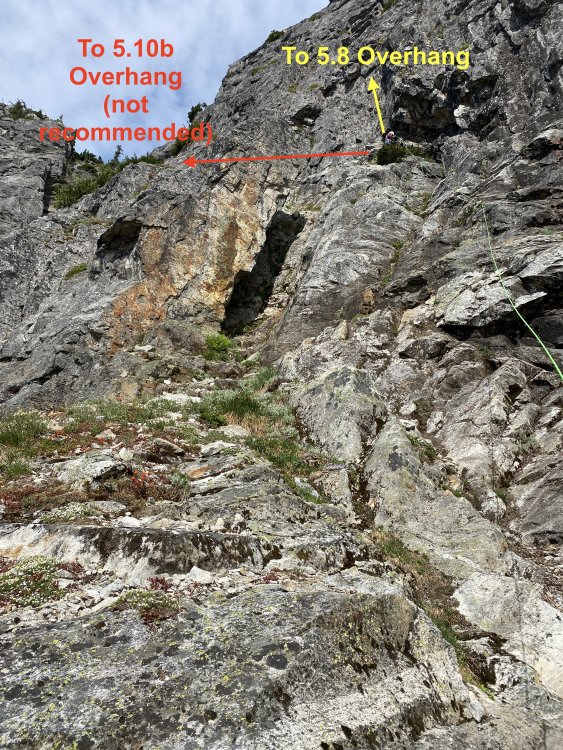
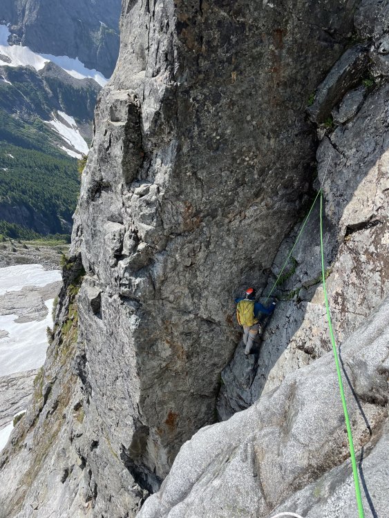
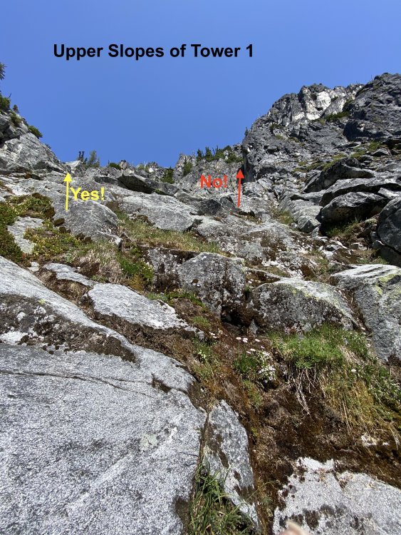
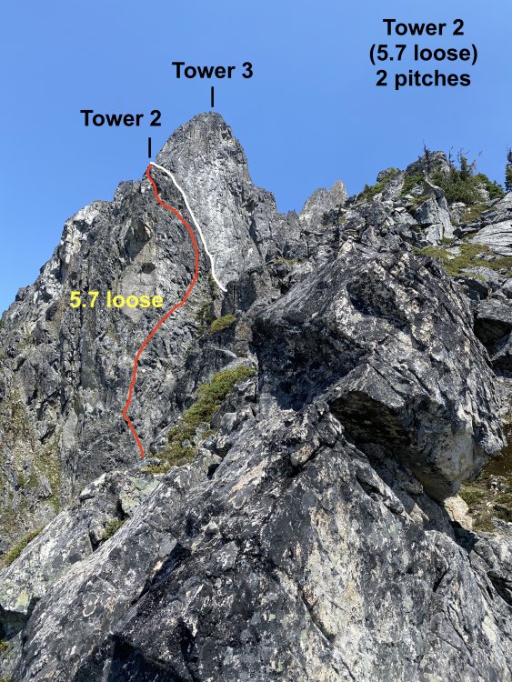
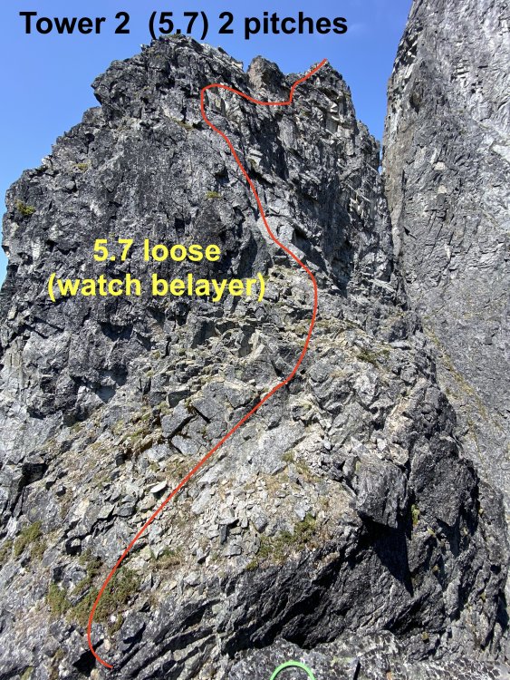
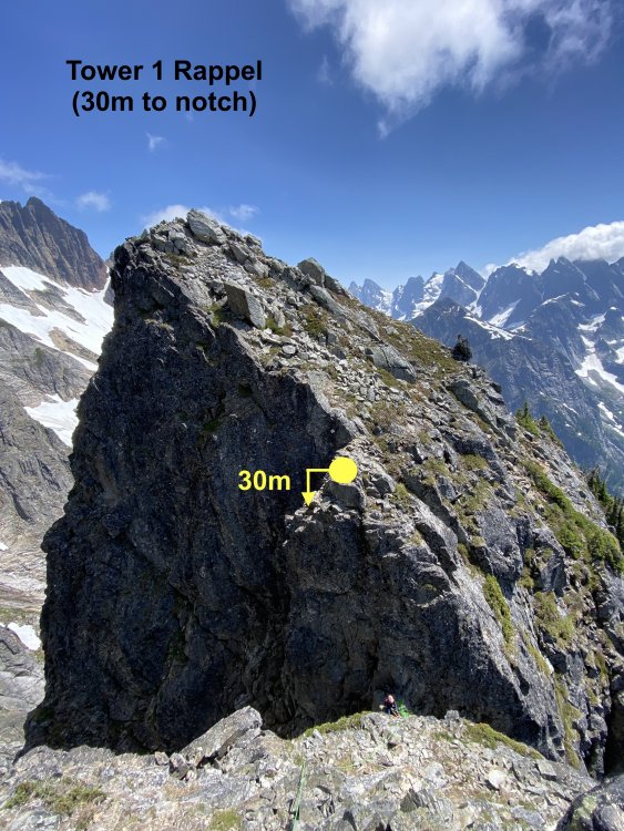
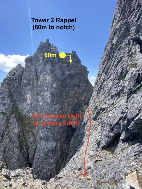
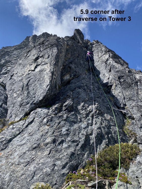
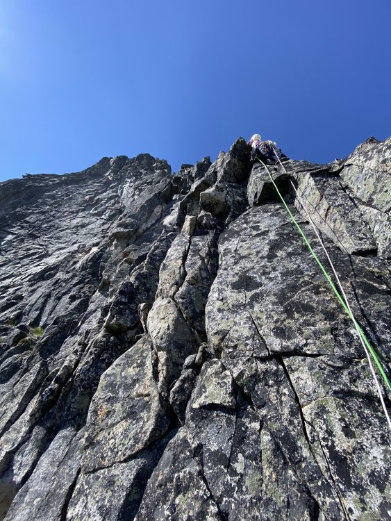
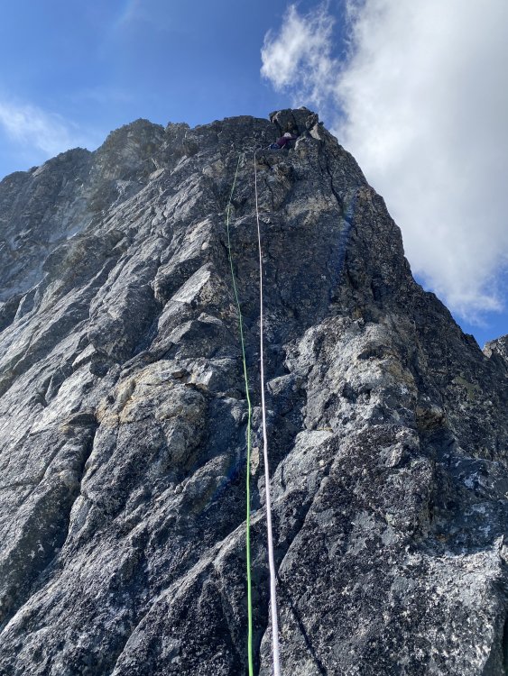
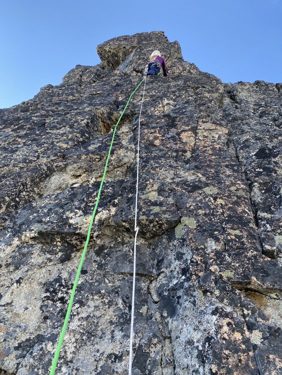
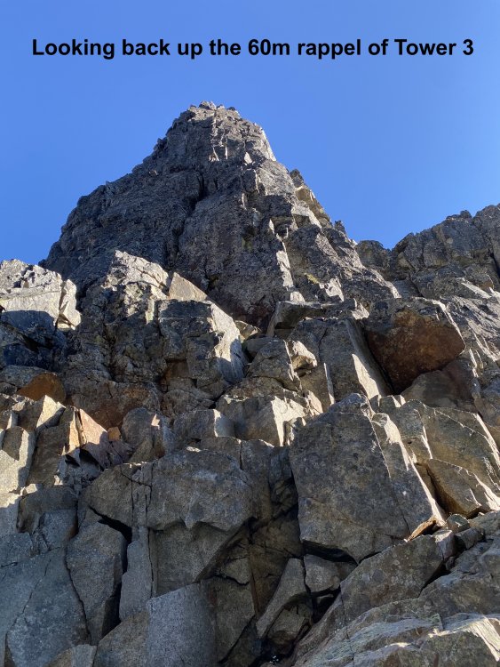
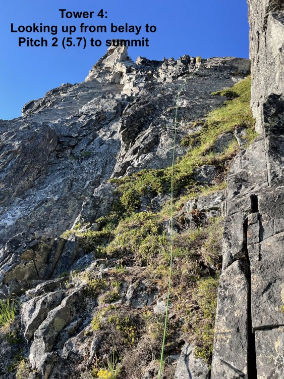
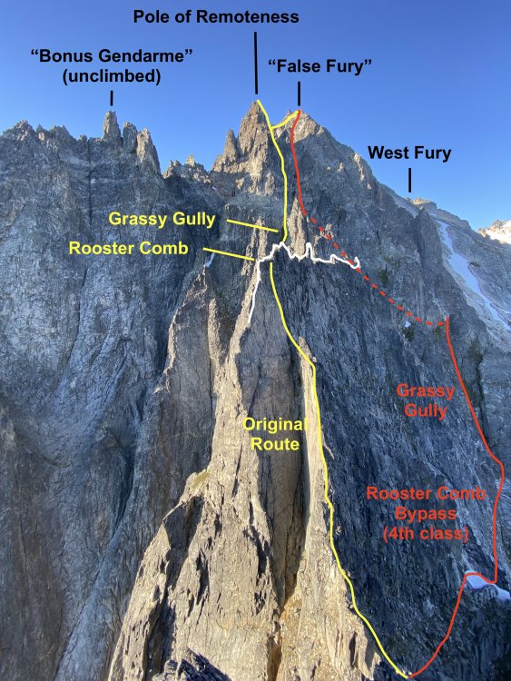
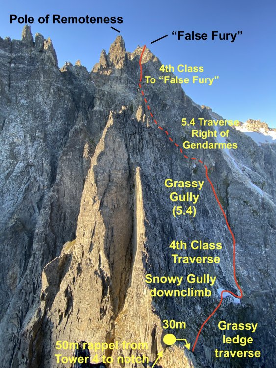
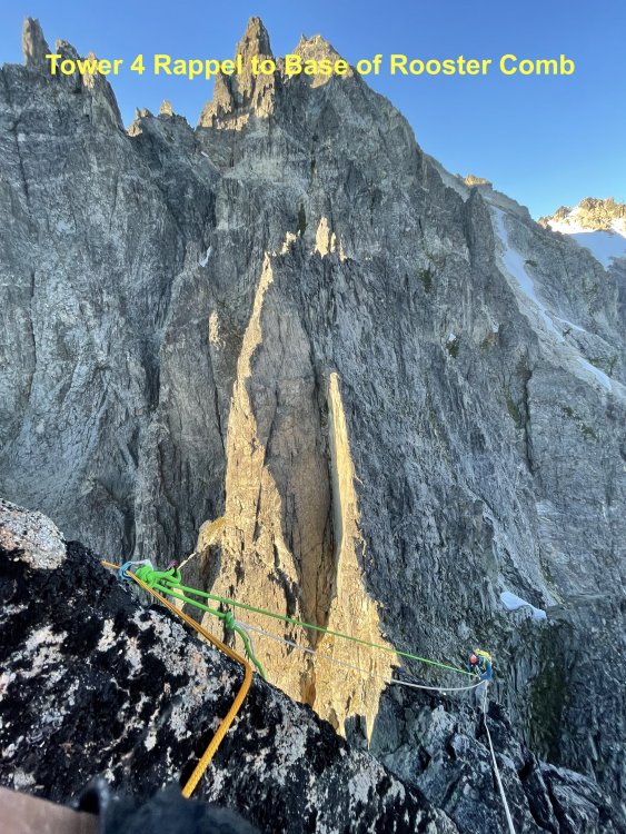
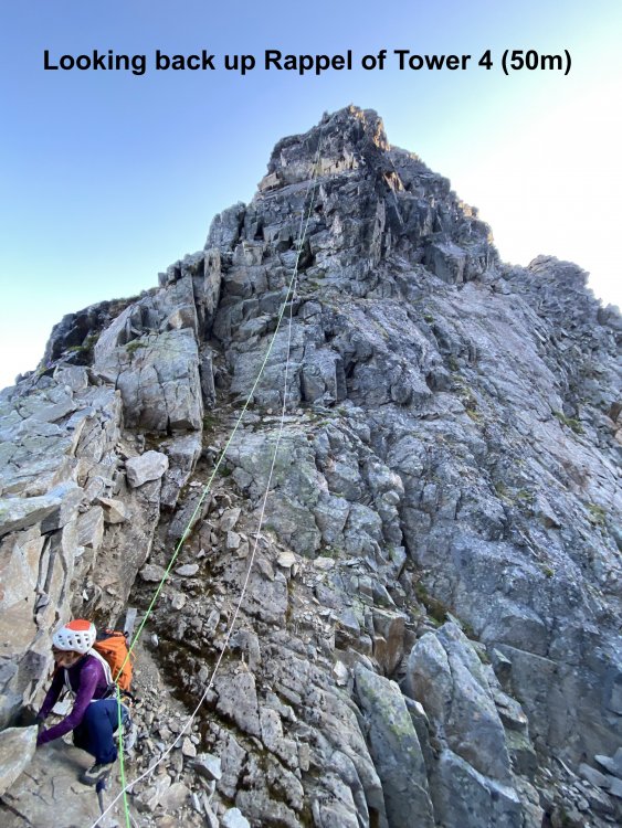
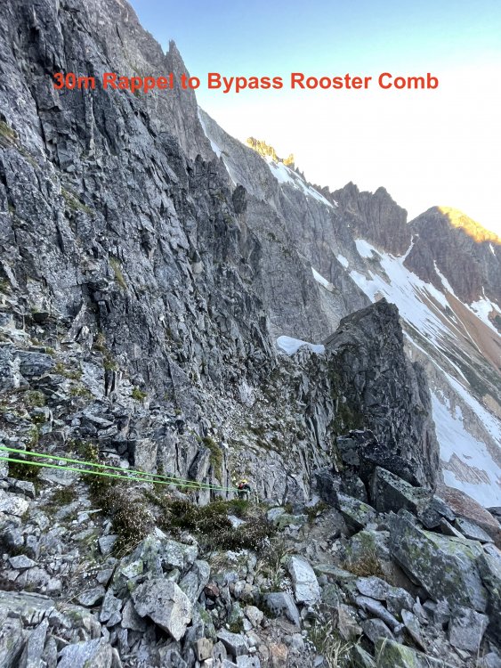
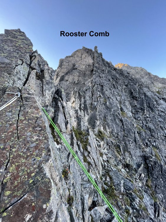
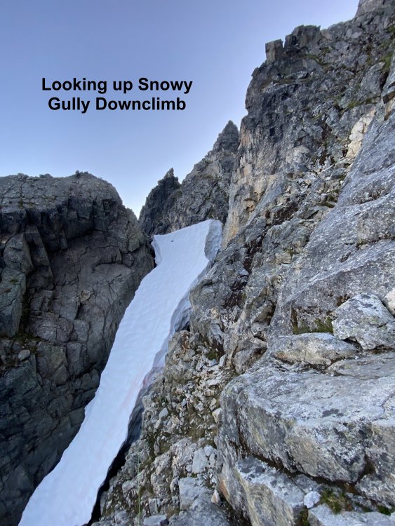
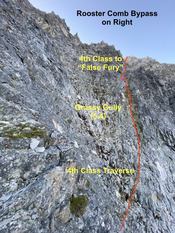
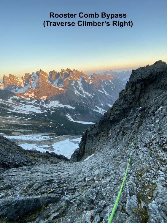
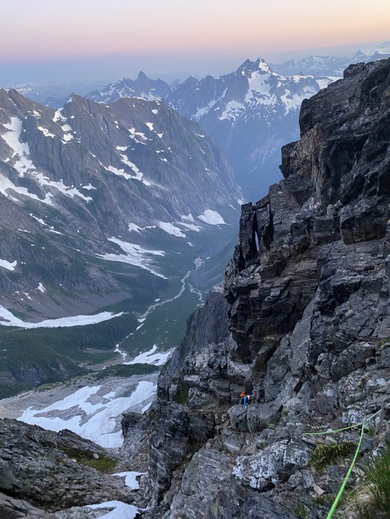
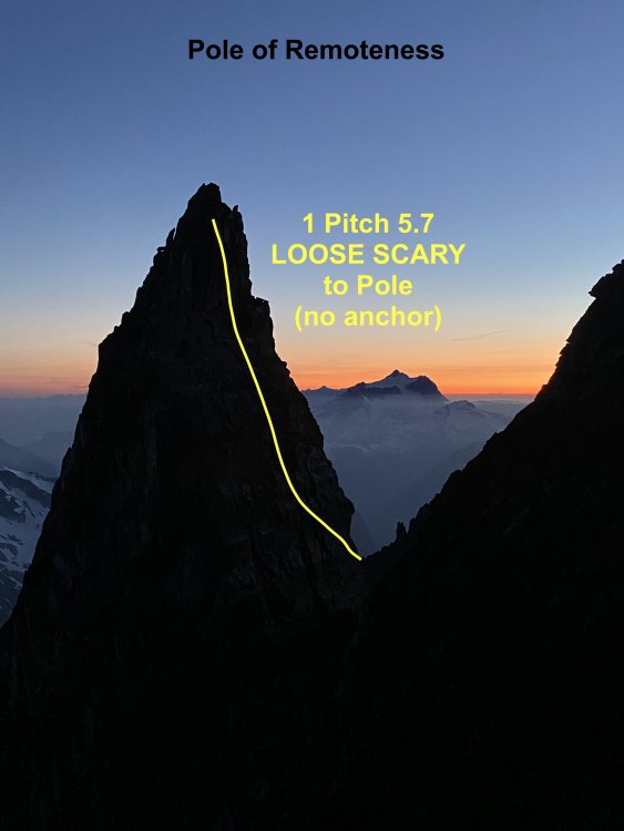
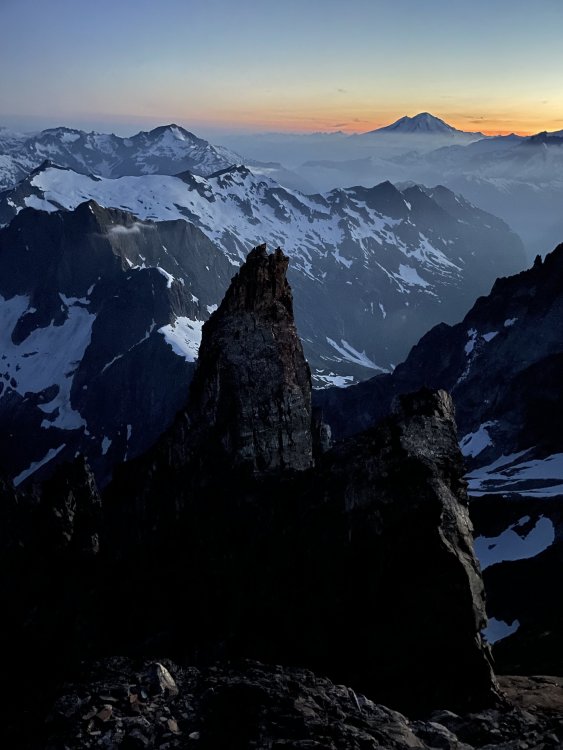
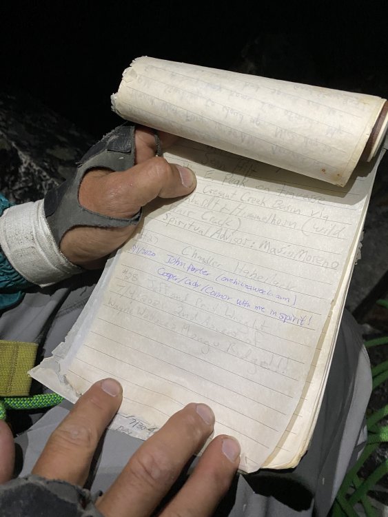
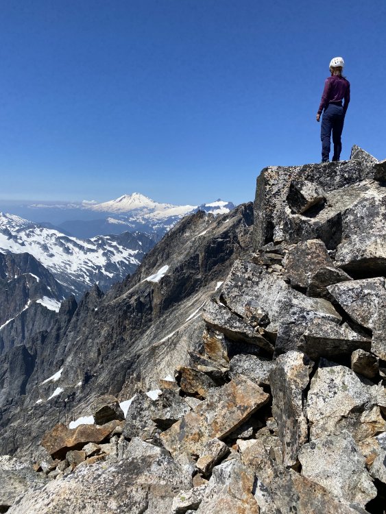
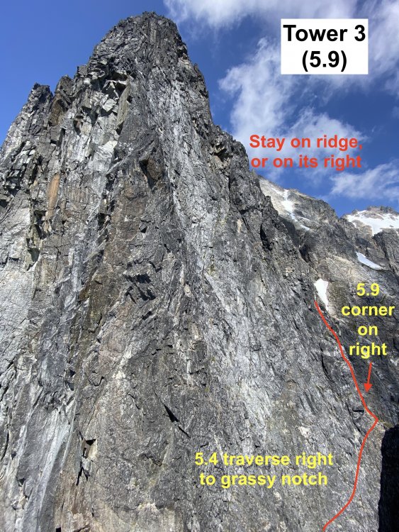
Trip: West Fury - Mongo Ridge Trip Date: 07/05/2021 Trip Report: In our relentless pursuit to ride the coattails of THE Wayne Wallace, Priti and I made the second ascent of Mongo Ridge (the SW Ridge of West Fury in the Northern Pickets of the North Cascades). It is a Stegasaurus ridge which rises 4,000ft over a mile from Goodell Creek punctuated by thick clusters of gendarmes that look like they’re straight out of the Karakoram. We first heard about Mongo when Wayne came to speak for a BOEALPS - Boeing Employees Alpine Society Banquet in 2015 and regaled a captive audience with his bold adventures. We warmed up Wayne's feature presentation with a talk on our trip to Patagonia climbing Aguja de l'S. Then Wayne came on stage talking about Mongo, making de l'S look like a mole-hill. Wayne climbed this route in 2006 SOLO, like a boss, questing into unknown terrain that easily could have landed him into mandatory hard free climbing. With vertiginous cliffs on both sides, he knew that bailing from the route was not an option and that he had to climb whatever the mountain presented. The difficulties on the route were up to 5.9, with an additional 5.10b pitch (a routefinding error), but the towers presented possibilities up to 5.11 if we weren’t lucky enough to have Wayne’s beta. The first ascent is one of the legendary, mythical ascents of the Cascades and even of the climbing world. After 15 years, only a handful of folks to my knowledge have even considered attempting it again. The bottom half of the ridge has four narrow towers which require you to summit and rappel in order to make vertical progress on the ridge. Long, double-rope rappels and hard technical climbing discouragingly makes it take hours just to ascent 100ft at times. Above these four towers are the “Rooster Comb” and the “Pole of Remoteness” (named by John Roper who figured it was the hardest place to get to in the lower 48). After Tower 4 and before the Rooster Comb, we scramble traversed low around each of these features and did not summit the Pole of Remoteness since it was getting dark and we did not bring bivy gear. At Wayne’s suggestion, we planned to climb camp-to-camp which was situated at the summit of East Fury. This means that while we did ascend the topographic feature of Mongo Ridge to the summit of West Fury, we did not truly climb “Wayne Wallace’s Mongo Ridge” in the manner that he climbed, including many more pitches of technical terrain. When we talked to Wayne in 2019, I told him that “Somebody needs to repeat this route, just so the world can understand what you accomplished.” It’s impossible to understand the scale of this route without being on it, competing as “one of the largest features on any mountain anywhere.” “You have to climb a major mountain [East Fury] just to start a most major climb.” Even with Wayne’s pictures and descriptions, we were still filled with dread as we attempted to route-find up each tower. While I am proud of what we did accomplish, I am still shaken at the boldness and audacity of the first ascent. Our tale should be considered a celebration of that event. Wayne called it Alpine Grade VI, but Beckey downgraded it to V deeming it (incorrectly imho) similar in commitment to Slesse NE Buttress (ref. Cascade Alpine Guide Book 3, pg. 118). We concur with Wayne's Grade VI rating, although I won't be even slightly offended if anyone wants to challenge the grade while ensconced in sofa cushions. Our itinerary: -7/3/21: 2PM boat ride from Ross Lake Resort to Big Beaver TH. Bivy in Access Creek basin. -7/4/21: Access Creek Basin to East Fury Summit. Left summit bivy in situ. -7/5/21: 23hr day camp-to-camp including Mongo Ridge and the traverse from West Fury to East Fury. -7/6/21: East Fury to Access Creek Basin -7/7/21: Access Creek Basin to Big Beaver TH. 2:30PM boat back to RLR. Here are collected links regarding Wayne's FA, for reference: https://waynewallace.wordpress.com/2014/05/ http://www.alpinist.com/doc/ALP19/climbing-note-fury https://www.nytimes.com/2006/10/21/sports/othersports/21outdoors.html http://www.alpenglow.org/nwmj/07/071_Mongo.html http://publications.americanalpineclub.org/articles/12200713002?fbclid=IwAR0iS9vNBvJ1XUQPOTPIXy8eymiTsuWFHI5TJtuAvLJUNb5LknfgeYgTriI Scurlock Picture: https://www.pbase.com/nolock/image/65948954 I won't go through too much detail on our approach to Luna Col and East Fury, since it is detailed well in many other places: https://onehikeaweek.com/2020/08/02/mount-fury/ http://www.nwhikers.net/forums/viewtopic.php?t=8021967 (specifically useful here is the traverse from East Fury to West Fury) Since we planned to do the route camp-to-camp (situated on the summit of East Fury), we studied the traverse from West Fury to East Fury in detail since we figured we'd be onsighting it in the dark to get back to camp. I will point out the "Red Ledge" (pictured above) just past Luna Col is reached by staying directly on the ridgeline from the col to begin the traverse over to East Fury. Past the Red Ledge, the next tower (called "Crux Tower" in some reports) is ascended directly via 4th class ledges and short 5.4 steps. A rope and gear would not be useful here. There is significant foreshortening here, as the route looks much more accessible as you get closer. Unless you're climbing in Winter or Spring, you will not be able to get across the bergshrund (as shown in the Beckey overlay), but instead will traverse left then right to reach the summit arête. Furthermore, the approach to the base of Mongo Ridge from East Fury's summit as discovered by Wayne is the easiest approach. While it is possible to reach Mongo's base via Picket Pass (either by navigating over Outrigger Peak "Southeast Peak" or Otto-Himmel Col), these approaches would be significantly more effort...or bushwhack for days up Goodell Creek. As you approach, notice the grey washboard streak with an overhanging gully. The route will start to the right of this feature. The 4,000ft descent from East Fury's summit may involve a lot of slab if the snow levels are low. We regret not bringing bivy gear on route. An alternative itinerary could be: -Day 1: Big Beaver TH to Luna Col -Day 2: Luna Col to Mongo Ridge Tower 1. Option to leave stove and tent on East Fury Summit as you pass by. There are no good bivouac sites on route. Just bring a sit pad and a sleeping bag and open bivy if splitter forecast. -Day 3: Tower 1 to either East Fury or Luna Col. A note on weather: The Pickets have notoriously unpredictable weather. Even with a splitter forecast, you can still have rain or even storms. Consider a tarp as backup shelter. Crossing the moat is the first crux. The moat is huge! Only found one place where it touched the rock slightly. On the approach, don't come down anything you can't go back up! Here I had to cross a giant moat (unprotectable compact snow), using both Gully tools (then passed the tools down to Priti). A picket here would have been very useful...but that's a big cost. Might have to bury a tool and rap/swing across the moat. Tower 1 was a TIME KILLER! Wayne reported a 5.8 overhang crux which we did not find. Instead we got suckered into a runout 5.10b overhang in the grey washboard gully. Recommend future parties to avoid this gully completely, and instead stay on the face to its right. Our second mistake was getting suckered into a difficult 5.8 grassy gully. Wayne later clarified that he immediately captured the ridge first, then went straight up the ridge (recommended). We started in an obvious chimney (5.6), gaining the face on the left then going right (many variations). After the chimney, we went left to the 5.10b overhanging grey gully instead of going up. It looked harder to gain the face above, but it is 5.8 if you can find Wayne's Way. The slopes to gain the ridge are all STEEP. We breathed a sigh of relief once we were on situated on the upper slopes of Tower 1, but route finding continued to be a challenge. A 30m rappel took us down to the notch between Tower 1 and 2. It seems possible to bail here back down the glacier and back up to East Fury. Perhaps the last legitimate bail option, so we considered the time and knew we would be climbing through the night. Tower 2 is only 2 pitches of 5.7 with no real route finding difficulty and went pretty quickly. The rock is REALLY loose however, so I was careful not to knock anything down on my belayer. Route lines are all approximate by the way! The first double rope rappel from Tower 2 led to the notch between Tower 2 and Tower 3. Tower 3 is the technical crux of the route and another TIME KILLER! It takes hours just to gain 100ft elevation. Once atop, it's demoralizing to look down and see the top of Tower 2 so close. Wayne reported a 5.10a bulge which I think we avoided by staying on and just right of the ridgeline. From the notch between Towers 2 and 3, a 5.4 traverse gains a grassy belay with 5 more pitches above ( 5.9 30m, 5.9 30m, 5.9 30m, 5.9 50m, 5.6 65m). Priti stopped whenever she found a good belay spot. We also hauled packs on 4 pitches expecting 5.10a climbing at any moment. It was real 5.9 climbing, consistently on decent rock for four pitches. Next time, instead of hauling just load everything into the follower pack and leave the leader with a mostly empty backpack instead. We took two backpacks on this climb to evenly distribute weight and bulk while simul-climbing. This was a good method. We consistently trended right above the belay. Higher Hiiiiiigher Hiiiiiiiiiigher Another 60m rappel deposited us to the notch between Towers 3 and 4. Finally, we got through the technical crux and we were losing sun fast! We knew we were in for an open bivy or a heartbreaking omission of the Pole of Remoteness. Tower 4 is another quick one. Two pitches, 5.9 then 5.7. It looks like really hard climbing going straight up! Instead we followed Wayne's advice and traversed out right for ~20m on 5.9 terrain with decent protection, then up following flakes and grass to a good belay. As you start climbing up, the climbing doesn't ease up, but instead is engaging, fun 5.9. Then 65m simul-climb to the summit. A final 50m rappel down to the base of the Rooster Comb. We were a bit confused here since the terrain opened up into a minefield of gendarmes. The Pole of Remoteness was indistinguishable among all of the towers. We knew we had to boogie so we took all the shortcuts that we could find. We noticed that the Rooster Comb could be bypassed on the right on low-5th terrain by taking another 30m rappel, then down climbing and traversing its Eastern flanks to a grassy gully. Wayne went up and over the Rooster Comb, not realizing there was a bypass. The Rooster Comb is very complex with several small flagpoles that required rappels. Wayne describes the final rappel off the rooster comb as a "diagonal rappel" that you can redirect off of horns, after which he flicked the rope to retrieve. There are at least two more intermediate gendarmes between the Rooster Comb and the Pole of Remoteness that we skirted around. Wayne found himself on their left side while we were on their right side. Wayne captured the upper 4th class slopes via a grassy gully (shown above). From here it's all 4th class to the "False Fury" summit. I coin the label "False Fury" because we stared at this point almost along the entire route thinking it was the West Fury Summit, but instead is fairly far from the true West Fury summit. Above is pictured our Rooster Comb bypass route which required an additional 30m rappel (or easy down climb). This was the first time we encountered snow on route, but don't count on it being there! Bring 4L water each. Southern Pickets in all their glory. Wayne traversed around the right side of the Pole of Remoteness to reach the col and summit it from the backside. To climb it directly would probably be 5 pitches of hard, loose climbing. From the notch between "False Fury" and the Pole of Remoteness, Wayne reported 1 pitch of 5.7 to reach the summit of the PoR. There is no anchor on top, so he threw a rope around a loose block and solo downclimbed, using the rope as a backup. If you are a team, consider downclimb-belaying. We sadly felt the need to skip the pole since it was total darkness by the time we got to the notch with a lot of traversing left to go. Once atop "False Fury", we couldn't find the summit register and realized that the real West Fury was maybe .25miles away separated by 4 more gendarmes, first downclimbing (or rappelling) down and right and traversing around the first gendarme, then weaving up, over, and around the others to finally reach the real West Fury summit. Glad to have put in the time to memorize the traverse beta between West and East Fury, it went off slowly but smoothly. One piece of key beta was at the end of Tower 1 (the last tower between the Fury's), you can find a secret 4th class ramp around to the North (climber's left) to find the rappel station that leads to the final push up the slopes back to East Fury. This is a 30m rope stretcher rappel, by the way! Thanks to Wayne for all of your support and encouragement! I think this route is more of a classic in the way that Hummingbird Ridge is a classic. We should really just sit back and marvel at the first ascent. It's a true Picketeering adventure, but loose rock, lack of bail options, and lack of bivy sites is pretty discouraging. The Pole of Remoteness still needs a second ascent, however! But it would a pretty doable day to get to PoR in-a-day from your East Fury bivouac by traversing high along the ridge and scrambling down from "False Fury", then reversing the route. Gear Notes: Single Rack .1 to 2, doubles .3-.75, small cams (TCU 00, TCU0). We like small cams in the Pickets! Small rack of nuts. 1 screw and 1 V-threader for glacier (didn't use). 60m single rope, 60m pull cord (three long rappels + optional pack hauling), 1 Petzl Gully (technical light ice axe) each, 10 single alpine draws, 3 double alpine draws, 1 quad, 50ft 5mm cord for rap anchors (used it all), left three caribeeners on rappel stations, steel horizontal front-point crampons. Approach Notes: Boat from Ross Lake Resort to Big Beaver Creek - Access Creek - Luna Col - East Fury - 4000ft descent on South side - Mongo Ridge - West Fury - Easy Fury


- 16 replies
-
- 11
-

-

-

-
- tripreport
- cctripreport
- (and 1 more)
-
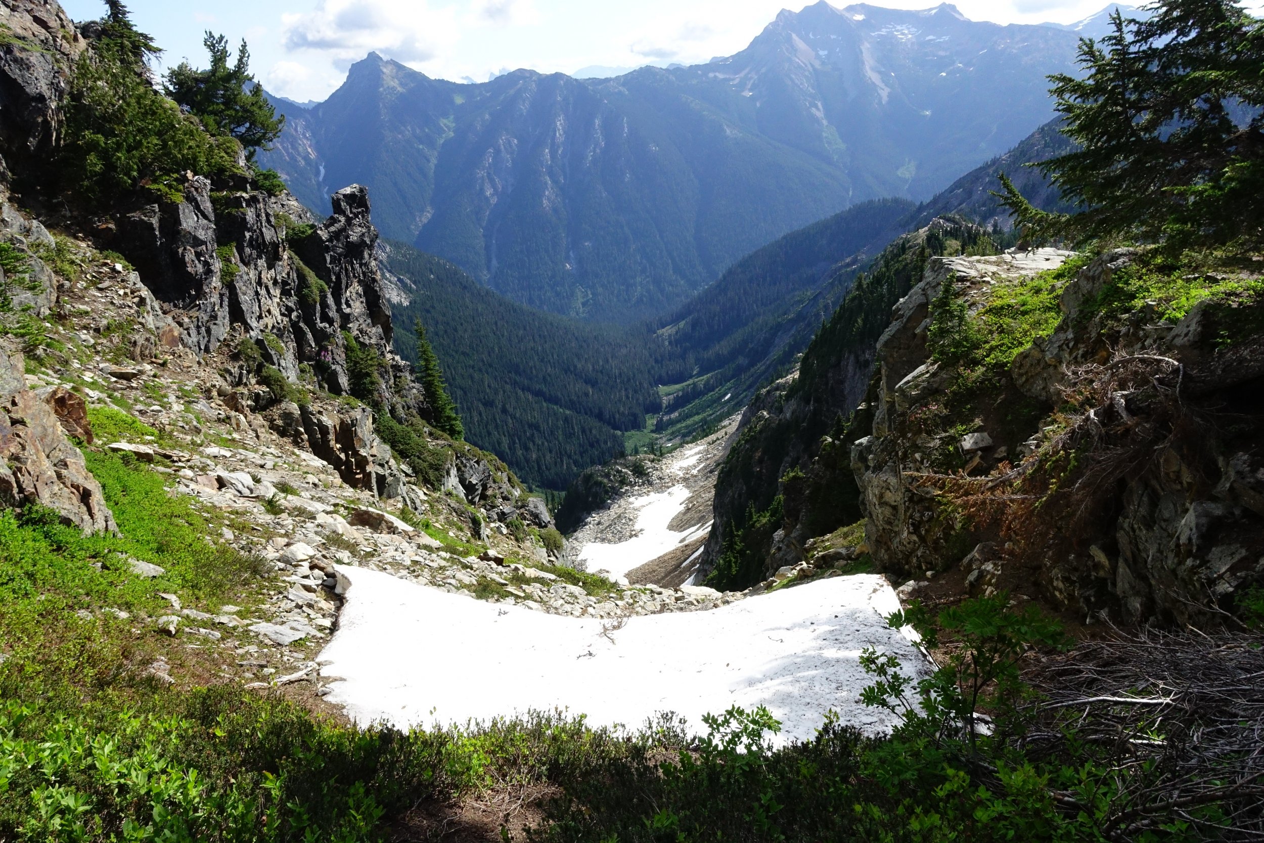
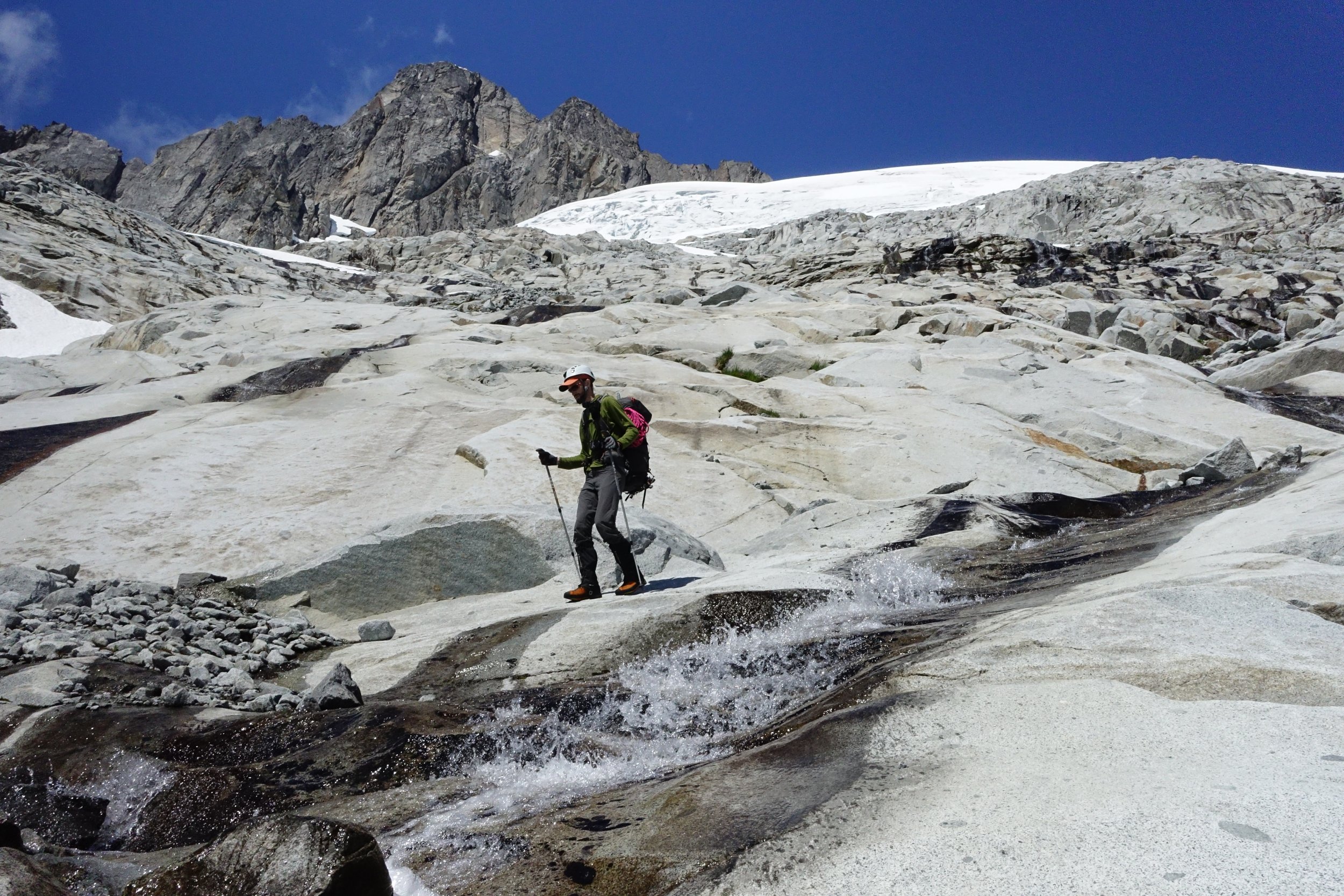
Trip: North Cascades - Mt. Challenger to Luna peak Trip Date: 07/13/2021 Trip Report: From 7/13 to 7/21 myself (Jeremy) and my climbing partner (Ben) traversed along the base of the Northern Pickets and did a bit of climbing along the way. The story, however, starts a bit further back than that. My first attempted foray into the Pickets to climb Challenger was 20 years ago, and it ended almost as soon as it began. A nagging knee injury irritated by 2 weeks in the Tetons and Wind Rivers flared up as I trudged along the W shore of Ross Lake...The trip ended before we even reached Big Beaver. I never quite got the disappointment out of my head, but living on the other side of the country made planning a successful trip back there a lot harder than I appreciated. One year it was too much snow and we climbed Ruth as a consolation prize...another year we fell short on time, turning around at Perfect Pass to make it out in time for our flight. Last year was a pandemic...I work in a covid ICU, and the idea of one of us contracting the bug and then getting symptoms in the mountains wasn't worth the risk. So here we are, 20 years later, and I was willing to give it one last go. I'm no spring chicken anymore...arthritis is off to a quick start, and I never really developed the discipline to train. I'm not even a weekend warrior, more like an every third weekend warrior, but only if it isn't too hot out, or if there isn't beer to brew or board games to play. In short, I am a softer, weaker, and somewhat more rotund version of my younger self that first had Picket dreams. This trip we gave ourselves 8 nights in case of bad weather and to accommodate my sub par fitness level, plus I wanted to visit Luna Cirque if time allowed. Having come in via Easy Ridge before, I wanted to try a different approach, one without an imperfect impasse, so we took the water taxi to Big Beaver. The water taxi driver asked about our plans and upon hearing them gave us a lengthy, silent, and knowing smile that communicated volumes- it completely psyched me out. Our first day was short, ending at 39 mile camp with smoke haze visible on the peaks above us, though we couldn't smell it. Day 2 dawned with no smoke from the east side fire. We took the trail to Beaver Pass, leaving it about 100 meters past the shelter. The bushwhack over to the narrow rib wasn't bad at all, nor was travel to the first cliff band. After that things got steeper, and the going slower. It didn't help that I had gone a bit light on food and decided to ration the first 3 days...2 granola bars between breakfast and dinner was rough. Upon reaching the top of the second cliff band we filled up on water, knowing we would probably not make it much beyond treeline. We followed beta from the many helpful trip reports on this site to bypass the cliffbands, making camp around 5600' where the meadows begin. Bear scat was noted there, and the mosquitoes had me pull out my head net for the first time. We enjoyed sunset on Luna Peak and turned in for the night. Day 3 again dawned clear with no smoke. While we could see the fire clearly to the east near the pass, the smoke blew north and presumably east for the remainder of the trip. We made good time to the beautiful pools others have mentioned finding and stopped for breakfast. We had a bit of trouble crossing a tree lined cliff descending from north of Eiley lake, but once we found the correct gully we made it up to Eiley lake without too much trouble. Wiley lake followed soon after, and we had a decision to make. We had the most beta on the descent from 7374, so we opted for that instead of trying to wrap around the Wiley glacier. I think I messed something up on this descent, but we did make it down safely, albeit via a more circuitous route. We traversed through a notch and behind a snowpatch (moat) on easy ledges to reach a slope of black talus. This snowpatch lies at the head of a large talus and scree gully others have written about. We didn't see a way to keep traversing skiers right safely, so we descended snow and heather benches to skiers L, wrapping back N briefly up a ridge with goat paths to access easy scree and talus that led to snow in the basin below. This basin lies at the bottom of the large talus and scree gully we crossed when we came through the notch. From there snow patches linked us up to the Challenger glacier, which we took up to Challenger arm and camped. Day 4 we woke to whiteout conditions and gratefully slept in. Around 2 pm things cleared up and we made a push for the summit of Challenger. We had no crevasse difficulties, but shortly before the bergschrund the clouds rolled back in and wiped out visibility again. The bergschrund was still bridged, so we decided to go for it. I placed a few pickets up to the arete and over to the rock tower, especially since I couldn't see the consequences of a fall due to visibility. The rock pitch was attention getting...I used both my knee and belly mantle techniques to less than graceful effect, but made it up nonetheless. Ben belayed me over to the summit and I set a line for him to follow. I couldnt find the register, so we snapped some quick photos and got out of there...wind and cold were both unrelenting. I again set pickets on the steep snow, and we cruised back to camp once past the bergschrund. Day 5 was clearer, though by now I was really starting to slow down. Two days prior to starting this trip I had just finished a 40 mile backpack in the Glacier Peak wilderness, and was starting to feel the cumulative effects. We headed down into Luna cirque. While slow going, we never got cliffed out or had to backtrack. The snow patches were starting to get ugly on the margins, and there was a lot of water running underneath, so we opted for the slower talus and heather slopes below. Long after my knees had hired a lawyer and issued cease and desist orders, we finally reached the flat sand and gravel camp site that splits the large lateral moraine at the base of Luna cirque. This was easily a top 5 campsites of all time spot for me. I stayed up late just to experience as much of it as I could. The ice and rocks hurtling down the 4000 foot amphitheater walls all around us was an unforgettable experience. We saw one set of older boot prints here, but otherwise just goat prints. Day 6- I found myself not liking the look of the descent of the moraine..lots of vertically stacked boulders looming above a steep slope of dirt...so we opted to descend around the outlet of Lousy Lake. There were some tedious patches of alder on the traverse around the arcuate moraine, but I didn't find it to be too bad...Ben may not agree. Most of the alder on the west side of the lake was dead or dying from some sort of tent caterpillar. We forded the outlet stream and made our way up uncomplicated talus slopes to Luna Lake. There we had lunch and a swim before heading up to Luna pass.We found a weakness in the cliffs just to climbers left of a large drainage/gorge angling down the flanks of Luna that required only a 5 foot rock step and no bushwhacking, After that it was slabs, snow, heather, and talus up to the pass. Temps were not high, but the sun was powerful and this climb really zapped me. We made it to the pass well before sunset and had it all to ourselves. We had considered Fury as a stretch goal for the next day, but both of us were pretty spent at this point and decided to give it a miss. Day 7...We climbed up to the false summit of Luna and spent some time enjoying the views. I had no interest in trying to get over to the true summit...I'm not working on my Luna peak merit badge, and I despise the combination of loose rock and exposure, so I contented myself with the false summit. That afternoon we rested and prepared our knees for access creek. At sunset we saw our first person since 39 mile camp. Day 8 we descended steep rock and heather below the pass, mostly avoiding the undermined snow patches. We found a reliable social trail that took us to the correct notch for descent into access basin. This descent was much, much longer than I realized, and my knees were whimpering by the time we made Access creek. There we got good beta on the route out from a pair headed to Fury. We lost the social trail in the woods a few times but even without it this was easy going. The final drop to Big Beaver was punishing but clear most of the way. Flagging marked a safe and shallow ford of Big Beaver next to a logjam. From there it was an easy walk up to the trail and down to Luna camp for our last night. Day 9 Up early to make boat taxi at 1015, retrieved beer from lake, and met our ride back at SR20. I've been eating hourly since then. Final thoughts. In spite of the extra climb over Hannegan pass and the tedious detour below the impasse, I thought Easy ridge was the easier approach as compared to Eiley Wiley. If I had to go again, I would probably go earlier in season and take the Whatcom glacier route to Perfect pass. Bugs were quite bearable, only used bug juice once and headnet twice. If anyone needs details on any of the navigation I can reply below. I will try to post some photos tomorrow if I get a chance Gear Notes: Bug head net, Fritos, bottle of Aleve Approach Notes: Big Beaver to Eiley Wiley Ridge, exit Access Creek.


.jpg.60aea9ed73f8877533e95787c508b978.jpg)
-
Hello all, I'm planning a trip at the end of the month into the Southern Pickets. Planning to spend two nights in Terror Basin and take a day trip up West McMillan Spire. May also try to go up the Pyramid but that's less likely. I'm interested in info/beta related to the following: Approach to Terror Basin Snow finger descending into the Terror Basin Camp State of Terror Glacier West Mac Spire itself Any other misc info (first trip into the Pickets) Lastly its possible we could extend the trip by a day. If you could extend this itinerary from 3 to 4 days what would you consider adding? E.g. summiting the pyramid, spending a night in Crescent Creek or Chopping Block camps, etc Thanks
-
Trip: Inspiration Peak - South Face Trip Date: 09/02/2018 Trip Report: Before last weekend I hadn't been to Terror Basin in almost 10 years. Back then we had spent a week in the Southern Pickets, only seeing one other party in Terror Basin. How times have changed! This past weekend there were three other parties for a total of a dozen people in Terror Basin. Thankfully all the others were headed for West McMillan Spire so we had the decidedly unpopular South Face of Inspiration all to ourselves. However, like Alan Kearney, I really think it should be more popular. It is quite a route! But it is also not for the faint of heart. Steep, intimidating, with a bit of scruffy rock and so-so pro - it would have been a challenge back when I was in good rock climbing shape. And I am most certainly not in good rock shape these days! Luckily I had @therunningdog to gun my sorry ass up it. And gun he did, leading all the gash pitches. But there was plenty to keep my mind humming below- a chaotic glacier with some delicate bridges, slabby rock right off the glacier (should have put on rock shoes earlier), and an increasingly exposed 4th/low 5th class ramp that terminated in the intimidatingly steep "Great Gash". And thenn once you are on the summit, the involved descent awaits. 4-5 raps down the West Ridge, some ridiculously exposed scrambling, and then more steep rappels down the south face. It was about 12 hours camp to camp. But what a place. Even more beautiful than I remembered, perhaps due to the changing weather and swirling mists? The best pictures are never during the best weather, perhaps the same is true of our memories? I'll be back, but I won't wait another 10 years this time. Looking down into Terror Basin from the "trail" in: Looking out to Triumph, Despair, and the Chopping Block (L-R): Despair and the Chopping Block: Thornton Peak and Triumph at sunrise: The Southern Pickets!! Morning light on the South Face of Inspiration: Ptarmigan and grown chick: I should draw the line on this but basically you climb up the buttress to the left of the face to the prominent ramp that is followed right a long ways to the start of the "Great Gash", which shoots steeply up and left to the upper West Ridge. A pitch on the ridge finishes the climb. The Descent follows the left skyline to the col then down the steep face/buttress to the glacier: The glacier approach proved challenging, but we found a way that will go into the fall this year: No super dad friendly. Scrambling a lot of 4th and low 5th to the belayed pitches up the gash. I should have taken more photos but I was pretty focused on not screwing up! @therunningdog in his element! Did I mention that the South Face of Inspiration is steep? @therunningdog coming up the final bit to the summit: It is an exposed descent as well. Rapping the West ridge: On the first set of raps, before you drop off the South Face: Whew. Down on the ice! Or should I say gneiss? TEEBOOOOOOOOOOOOOOOOOOOOONE! Despair in the mists: Triumph: Despair: This felt good after the punishing descent: Gear Notes: 60m half rope, medium rack to 2", ice axe, crampons, helmet Approach Notes: Terror Basin trail from Goodell Creek. 6 hours to camp. From camp follow the climber's path toward Inspiration and West Mac, picking the best line up the glacier to the toe of the buttress just west of the South Face. We roped up here for a bit until we gained the prominent ramp where we packed the roped and scrambled. It seemed about 5.6-5.7 for one ptich to gain the ramp, with low fifth below that. The "Great Gash" is about 3, 30m pitches, to ~5.8. I think we did about 12 rappels down the west ridge and west edge of south face right back to our boots. Stations are established for a single 60m rope. Bring tat since the route isn't climbed regularly.


-
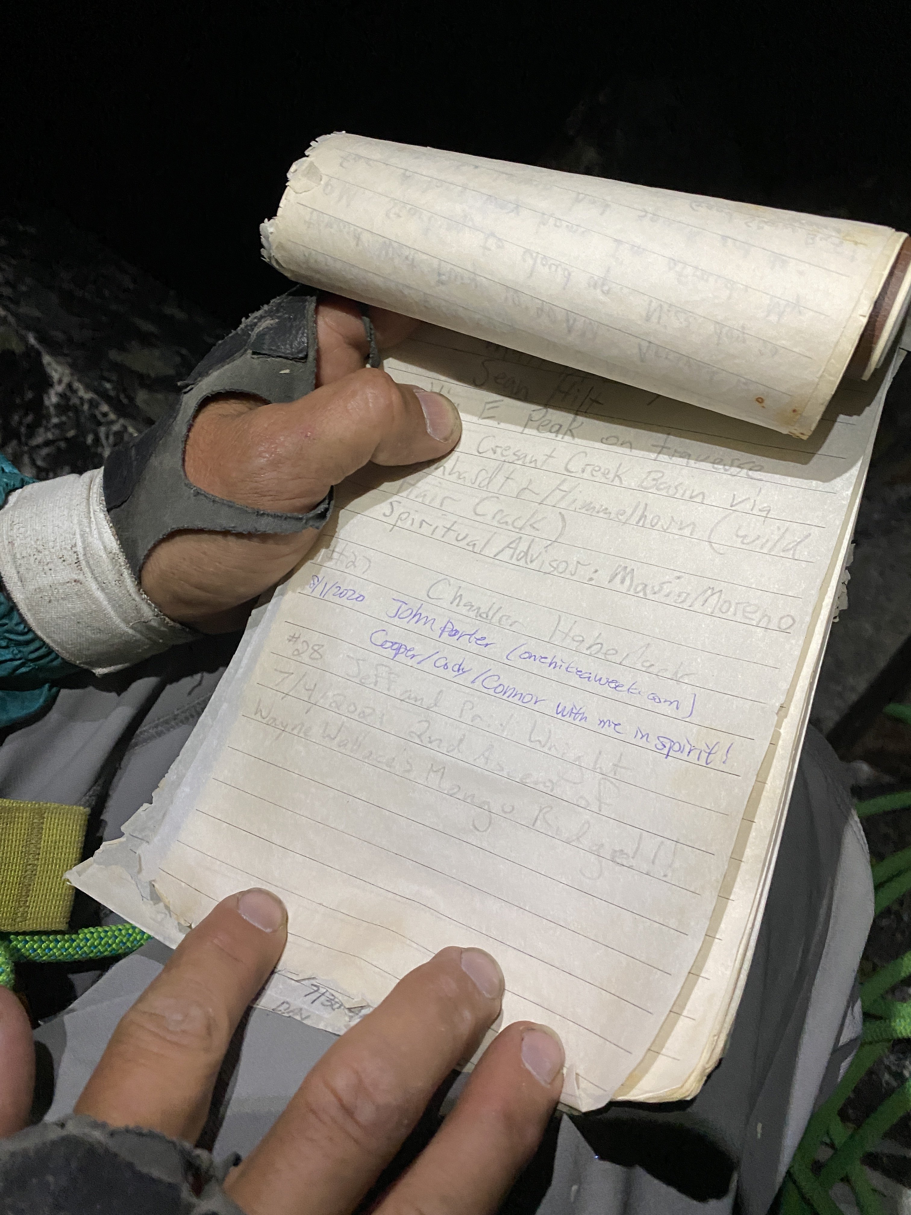
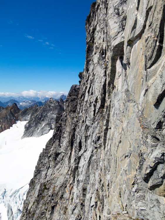
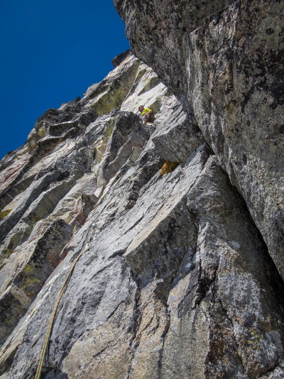
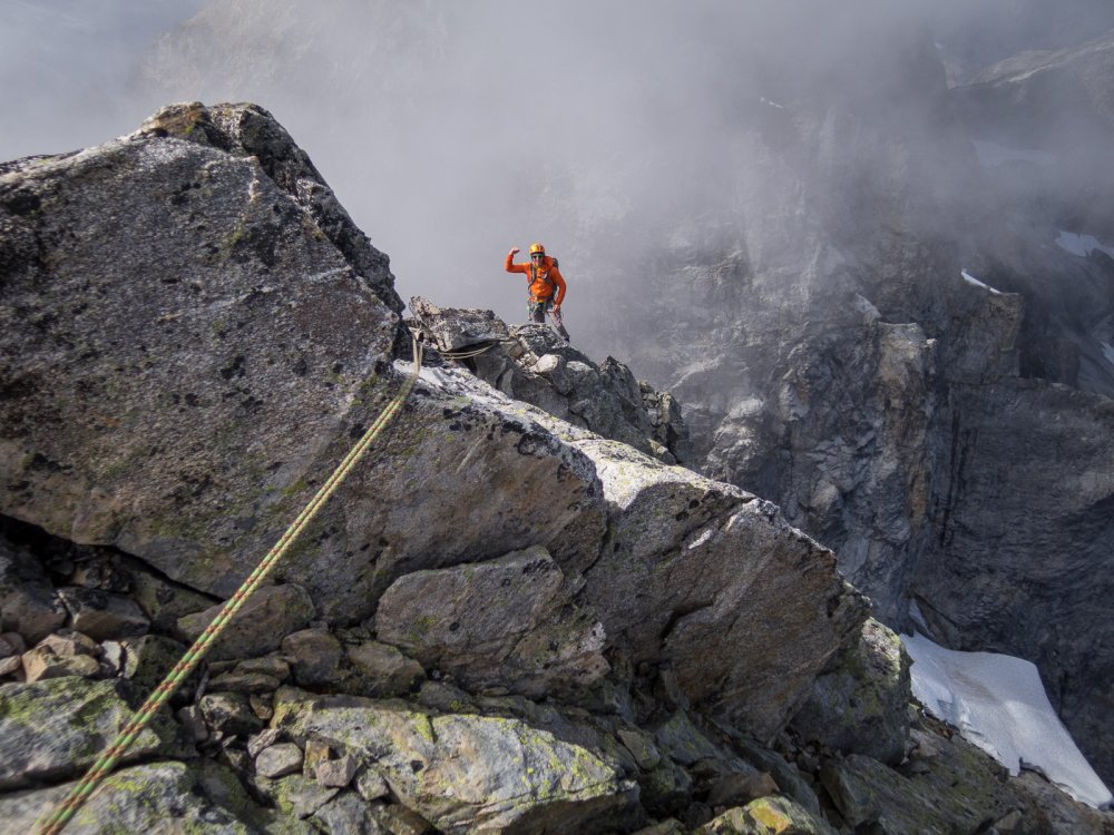
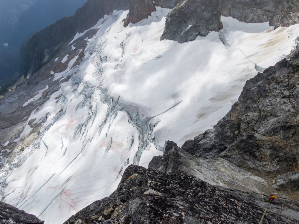
 Trip: The Pickets - Himmelgeisterhorn - Wild Hair Crack Trip Date: 08/25/2017 Trip Report: Well, it would seem that I completely missed larch season this year as we were gone yanking on tufas in Greece and now ski season seems to be well on its way. It was another fine year of climbing, the hustle was put on in the spring to tie up some loose ends on larger Cascadian objectives which was immediately followed by a great deal of Mountain Loop cragging in Darrington and a lot of heavy packing and choss chucking to bolt a new route up by Mile High Club. Amongst all of that I did accomplish a long standing goal in the Pickets with my good buddy Imran, a tick of the Wild Hair Crack on Himmelgeisterhorn. Wild Hair Crack is a route that was established by Silas Wild, John Roper, and Russ Kroeker in 1981. For all the information you really need to know about the route and the hilarious story of it's conception go to John Roper's site Rhino Climbs. There's a lot of other great info there too if you look around a bit. Years ago, on a short and brutal traverse of the Pickets from the Chopping Block to Luna with the Running Dog we briefly stood in the notch of Otto-Himmel Col and gazed up slack jawed at the crack, knowing that we knew what it was but not being able to summon the name. Regardless, we figured we should probably come back and climb it and headed off down the Mustard Glacier to Frenzelspitz Camp where we immediately got smacked by a standard Picket thunderstorm on an otherwise bluebird day. A few years of shameless peakbagging had gone by since then as well as other trips into the Pickets but I had not yet focused up to get back to that beautiful piece of rock. Imran and I set a date early this year, weather window permitting and waited for the weekend to arrive. We've done so many trips together at this point that communication went as it often does these days, we knew which guy was in charge of what and which version he decided to show up with was completely up to him. Park and Ride time was decided upon and the supply of whiskey was double checked, the weather was looking bomber. Northgate, Arlington, Darrington, Marblemount, and Newhalem all in a row, we snapped pics of guidebook photos and headed up the trail just about 8AM. We made our way down into Crescent Creek Basin past the Chopping Block a little after noon passing one tent at the divide. The clouds had lifted as we made our way across the Barrier and now we suffered the sunny choss as we contoured around Crescent Creek and climbed up below Terror, making our camp at the obscenely beautiful promontory at 6300'. We gutted our packs, piled rocks over the important stuff and took advantage of our lightened feet by scrambling up the West Ridge of Terror, tagging the summit right at 5PM. Back at camp we rolled cigarettes, set up the tent and sipped Laphroaig telling jokes and watching the sunset. The next morning we dropped a little elevation right out of camp and then contoured old terminal moraines towards the hidden couloir that leads to Otto-Himmel Col. Last time I had been through here it was early season and we had just strolled to the top, this time it was a whole different animal. We predominantly stayed in the moat on the left stemming between ice and rock until being forced through a portal in the snow to the right side. Below the huge chockstone we scrambled up the rock on the left side and then back across smallish ledges right until back in the gulley above the chock. A few more feet of vert brought us to the Col and a bit of a breeze so we added some layers and got our gear on. I started up the righthand of the two large cracks and climbed for a ways until it appeared as though the rock might be of better quality over in the left crack. Imran was shouting at me to stay in the right side but I figured I'd go check out the other one at about half pitch. I liked what I saw so I continued up, I suppose following the right side is what is shown in Red Fred but both variations were climbed in the process of seeking the first ascent by Silas, Roper and Kroeker so I figured I'd split the difference on the first pitch. Both lines will take you to the base of the next pitch in a little alcove/cave below the offwidth chimney. If memory serves me there was a small slung chockstone here with what must have been some tasty cordage that a varmint had chewed through as well as some other old webbing that was in slightly better shape. I threw in a cam as backup and made an anchor to bring Imran up. Once he arrived all smiles as usual I set about getting my nerve up for the next lead. It looked big, slightly overhanging, and I could not see anywhere that took gear less than eight inches; 5.7? I'll bite. Up I went, the holds were...amazing! All the stances, everything was like a dream. I almost forgot about placing gear, which wouldn't have mattered anyways because unless you have a Big Bro or a length of 2X4 it doesn't matter until you are at least 20' out. The first placement is a small cam in a horizontal crack to the right of the crack, the next, about 5' higher is a bomber #1 or #2. The angle eases off after this and the pitch rambles up a ways nearing the ridge. Instead of heading over the ridge to the left we opted to continue up towards the subpoint angling slightly right to a weakness and chocked chimney just below the subpoint. I belayed Imran up while sitting on the chockstone and we unroped for the next bit of 3rd and 4th class terrain up and over the subpoint and across the ridge towards the true summit. There is a nice flat col before the final pitch up to the summit and we threw our packs down here and put the rope back on for safety sake. I placed a 0.5 or 0.75 in a feature to protect a bit of exposure but that was it. We had reached the top of the "Horn of the Sky Spirit" and the horizon was smoke free, giving us views for days. The summit is pretty small, we looked around for a summit register but could not locate one despite Jason and Tim reporting on it during their FA of Stonehenge. We hung out up there for quite a while but eventually decided we were hungry and we needed to figure out how to get down. We knew we didn't want to rappel the lower three pitches of the Wild Hair due to a lack of anchors for our single 70M rope (FA was with twin 50M ropes) and we didn't want to end up too far down the N face and have to come back up the Mustard Glacier. We had spotted a pretty nice looking anchor backed up with a nut and some fresh looking webbing just below the subpoint on the north aspect so we figured we'd start there. I ran the rope through, tied knots and chucked each half into the unknown. Looking down the face everything looked pretty ledgey but also decked out with areas of obviously loose rock so I exercised considerable caution keeping the rope free of debris. At about 25M I came upon a double piton anchor joined together with some old webbing but decided to try and angle off back towards a large boulder out right (skier's left), suspecting a possible anchor in that vicinity. I came up on the knots right as I touched on a ledge above the boulder, I unweighted the rope removed it from my belay device and scrambled around the boulder to find a nice looking rap anchor. Imran came down and we set the next rap angling hard back over the ridge towards Otto-Himmel Col. We found another anchor over the ridge and were able to rap into a small depression almost at level with the col with a slight ledge leading back to the col, I believe this is the depression and ledge described in the N. Face route description. Stoked to have made it back down on our single 70 with relative ease we rapped down past the chockstone and continued to rap most of the gulley on old suspect singlepoint anchors composed around sketchy rock or attached to jiggly pitons in jiggly rock. Eventually we emerged back in Crescent Creek Basin and rambled back to camp encountering a rather large and healthy set of mountain goats along the way. Somewhat begrudgingly we packed up camp and made our way back across the hot red choss to the Chopping Block where we set up camp for the night and encountered a curious Stoat for a split second before it went back to hunting down Pikas and other alpine morsels. Sunset was amazing in all directions and the nice view of Teebone Ridge had Fallen Angel stuck in my head for the rest of the trip but thanks to 4G service at the ridge I was able to scratch the media itch. In the morning we climbed the NE ridge of the Chopping Block staying generally on route but adding in a few short harder sections at the bottom and top for fun. Rapping this route with a single 70 is a bit of a rope stretcher and requires attention to detail. Finally, we packed up for good and headed down the Barrier gorging ourselves on blueberries the whole way back to Terror Creek. Another trip in the Pickets with a head full of ideas for the next time. I had the good fortune to talk to all the members of the first ascent team at this years Bulger Party and I think they got a kick out of the kids taking such pleasure in their route, it is a real gem! Thanks to Silas, Russ, and Roper for putting up the line! Okay, Pictures! Coming up the Barrier with clearing skies Crescent Creek choss heat. Terror! With Luna in the background. Camp life. Sunset from camp. Highly recommended accommodations at ca. 6300' Himmelgeisterhorn Starting up the right crack, the chimney of P2 can be seen above the left crack near the top of the rock in the picture. Imran climbing towards the top of P1, minimal gear was placed on ascent but lots of opportunities existed. Last Pitch Sky Spirit! Taking the ledge back to Otto-Himmel Col Super Crack! Late season gulley shenanigans. Sunset from Chopping Block camp. NE Ridge of the Chopping Block Picket Stoke! Gear Notes: Single rack of cams #00-#2, medium nuts, long runners, 70M rope, crampons, ice axe, whisky Approach Notes: Terror Creek to the Barrier to Crescent Creek Basin
 -
Last summer, at a climber's get-together at Mario's house, i had the pleasure of meeting John Roper. For those of you who don't know of John, he is a towering figure of Cascades exploration, with thousands of ascents (including many first ascents) under his belt. He is also a member of the legendary Bulgers climbing group, and co-creator of the Bulgers Top 100 Peaks in Washington list. Suffice it to say i was enthralled, and managed to monopolize the conversation with him for much of the evening. A key question i asked him: of all those ascents, what is your favorite climb? Without hesitation, he said Wild Hair Crack on Himmelgeisterhorn. Its worth reading his writeup of that first ascent here here both because it is quite entertaining, and because it highlights John's reverence for the Southern Pickets. As something of a Picketeer myself, the conversation got me thinking: i had never been into Crescent Creek basin -- something i needed to rectify! As fall and then winter rolled in, i spent spare moments flipping through Red Fred, starting at the Challenger quad, and scouring the interwebs for lesser-known morsels about the Western half of the Southern Pickets. I also enlisted two good friends and climbing partners, Matt and Keith, in the project. Step one was equipping them with copies of Training for the New Alpinism. We are all mid-fourties to early-fifties, busy with families and careers, and so the luxury of getting in shape by actually getting out climbing a lot was out of the question. In its place, enter max strength box step-ups and weighted hill climbs. Less fun but quite effective. As our forth, virtual, team member, we had Mario, the person who introduced me to the Pickets 17 years ago, to act as my logistics co-conspirator as he recovered from shoulder reconstruction. I started brainstorming new lines during early morning training sessions at VW with Keith. Staring at Scurlock photos can do that to you. South Buttress on Twin Needles? Southwest Buttress on Himmelgeisterhorn? But what got me most excited was, while trolling through Roper's website, noticing mention of unclimbed peaks (peaks! not lines, peaks!) in the Pickets. What?!?! I homed in on Beep and Honk (named by John of course), two unclimbed sub-peaks on the unclimbed West Ridge of Ottohorn. That West Ridge, from the photos i had, seemed moderate and downright reasonable. An appropriate goal. Maybe. Wayne recommended to me years ago that to truly prepare for a Pickets trip, you need to get out on a couple of soul crushing training outings. We rounded down to one. On the Northeast Ridge of Triumph, on summit day I felt physically fit but mentally off, strung out after a surprisingly anxious night of non-sleep at high camp. Matt also wasn't feeling dialed in. The project seemed in doubt. As i get older, and particularly since becoming a father five years ago, risk and mortality are more mentally present when i'm in the alpine, sometimes to the point of making it just not fun. Had my ambitions outstripped my waning climbing ability and risk tolerance? We tempered our goals a bit, planning to climb Terror first, as a way to hopefully get some momentum before trying something new. This new framework got our team mojo back together, and with a reasonable albeit not stellar forecast, we headed off on our trip. In the afternoon Matt, Keith, and I began our hike in, loaded up on water after fording Terror Creek, and then headed uphill. We camped at 3600', to split the approach into reasonable chunks, which worked great. The next morning, with a mostly sunny forecast, we awoke in a whiteout. Here is how "Mostly Sunny" looks in the Pickets. We continued up into Stump Hollow, and over to the Barrier camp, and then sniffed out the correct place to drop off the ridge. We still had no views of the spires. But once we dropped in, the clouds started to lift, and by the time we arrived at camp below Terror, it was sunny enough to dry out and take in the scenery. That night the winds howled. Keith was nearly blown over during a nighttime pee run. We delayed our departure for three hours until the winds dropped. The weather turned fine as we hiked up to the Terror gully. The gully had begun to really melt out, and there was a tricky break in the snow (just above what is shown in this photo) that Matt led through with some nifty mixed climbing. I was happy to not have that lead! At the notch, after a bit of futzing around to find the best start, we began cruising up the enjoyable climb. Soon we reached the distinctive summit. On the descent, we used the skier's right side gully to bypass the tricky snow break. There was a rap anchor here, but it needed some love, so we beefed it up with a second piton and a better nut. It felt good to have Terror under our belts. So far, the trip was going right according to plan. The next morning, we hiked West below the spires, and gained the Southern Pickets ridge crest at the saddle just East of West Peak. We tagged West Peak, which is definitely worth a visit for the outstanding perspective. Here is Matt nearing the summit. You can see the goal for the rest of the day (the West Ridge of Ottohorn) laid out behind him. The summit views were outstanding (including Mongo Ridge over Keith's shoulder). Back at the saddle, Matt told us he was going to sit out the Ottohorn attempt. After talking it through, we repacked and Keith and I headed out into new territory. This picture taken by Matt a little later in the day shows the route over, from left to right, Beep, Honk, and Ottohorn. We began by hiking East along the crest. After a bit, it turned to a more defined rock crest, and i led a long simul-climb pitch to the base of Beep, the first tower. Here is me leading that block: and Keith following: Keith then led a steeper and somewhat heathery pitch up the start of Beep. I then tapped in for a fun pitch that began with thin cracks on a lichen-covered face, then worked up to dramatically positioned face climbing past a strangely shaped rock horn. Here is Keith following that pitch: And Matt, back at the saddle, watching us (look for the small red dot): Somewhere around this time, a helicopter flew by at close range, eyeballing us. We gave them peace signs and smiles. Not much later, a military jet blasted by right at eye level, less than a rope length out on the North side of Southern Pickets crest -- WTF that was loud! Keith then led us to the summit of Beep. We were pumped, an unclimbed summit in the Picket Range! That pump was only mildly deflated when Keith discovered that the sandwich he had packed for lunch was AWOL. It was 2pm and we had a lot more climbing to do. I led a intricate pitch of ridge traversing along the crest of Beep, and then located a lovely obelisk that could work as our rap anchor to drop off. A double-rope rap took us to just below the notch between Beep and Honk. Keith led a rope-stretching pitch up some of the finest climbing of the route, right to the summit of Honk. Unclimbed summit #2, check! I led a pitch that downclimbed delicately off the summit and traversed to the notch with Ottohorn, arriving at a comfy belay stance. This picture shows Keith as he was about to follow it. Keith arrived and we gazed up at Ottohorn above us. We were moving slower than desired, but were hopeful that the climbing would ease up. The belayed climbing so far had ranged up to 5.8, and we needed a bit easier ground to be able to move faster. However, hope is not a strategy... as we were immediately greeted with some tricky bits. Keith broke right around the corner. The pitch grew more challenging as he followed a set of steep steps upward. He followed that up with another strong lead that included a couple of 5.9 sequences, as he worked back to the ridge crest proper. At this point, it was abundantly clear that we were not going to finish the route before dark. Keith and i had "the talk" about bivying. Keith quoted the wise words of Mike Tyson: "Everyone has a plan... until they get punched in the face." We each have a couple of decades of climbing under our belts; i had experienced one unplanned bivy (with my now wife), and Keith had never had one. That clearly made me the expert, so i described what we should look for as we went home-shopping. We did one more traversy pitch along the crest. However, we then hit a notch where we had to rappel. The good news was that this rappel ended in a moat behind a snow bank. WATER! I felt smug as i filled my water bottles with snow. "At least we won't be dry at this bivy" i thought. Keith led one more pitch, and by the time i arrived it was time to hunker down. I explored and found a workable spot 15 feet below us on the North side of the ridge. After a bit of site remodeling, as the sunlight faded, i opened my pack to throw on some layers. I reached in, and to my horror, fished out a soaking wet shirt. I hadn't closed my water bottle fully (probably due to snow crystals in the threads), and it had leaked all over the pack contents. My puffy was wet too. It certainly wouldn't be dry at this bivy, all right. Keith reminded me of the mantra that both of our kid's preschools use: "you get what you get, and you don't throw a fit." I threw a small fit, and then moved on to laying down our two ropes as ground insulation. 10pm it felt great to be not moving, just talking. 11pm we tried to "sleep". Keith elected to use his pack as a bivy sack; i used mine as padding. We began hearing noises behind and above us. In my headlamp, i caught a large-eyed snafflehound chewing on my gear. Oh no you don't! I hung the gear from the anchor over my head. About every hour or two we sat up and talked about how increasingly cold it was becoming. We began to shiver and our toes got cold. Here is how we each looked in the morning. Finally it was light enough to start moving again. We were cold, hungry, dehydrated, tired, but in an amazing spot to watch the sunrise. We checked out of the snaffle-lounge, and got back on our way. Low-fifth climbing took us to the top of Ottohorn. You can see the excitement in Keith's eyes. Ok maybe he needs his morning coffee. We rigged a rappel off the Ottohorn summit ridge down to 3rd class terrain. However, as Keith pulled the rope, it got completely jammed. NO! I tried to get psyched up to lead back up and free it. A final desperate rope-flicking session by Keith managed to get it free. Meanwhile, Matt was starting to get worried. He had watched our progress on the ridge the day before, but hadn't seen us since late that previous day. Early in the morning he had hiked from camp back over to the base of the descent gully, and was yelling up to us. We yelled back, but he couldn't hear our responses, and so was beginning to fear that we were in real trouble. We scrambled down, gained the O-H gully, and arrived at the rap station above the giant chockstone. Finally, as we made that rappel, we established visual and verbal contact with Matt, to our mutual relief. Matt took this picture of us as we descended. Face-in downclimbing of the snow gully, tediously slow in our depleted state, took us down to Matt and the sunshine. We were wasted. And happy. And thankful. I declared my intent to retire from the sport. We rehydrated and refueled, then stumbled back to camp. Mr. Ed the camp mountain goat nosed around while Keith dozed in the tent. Matt hiked up to the shoulder of Degenhardt to stretch his legs. I sat by a melt stream and processed the climb we had just done. I felt a lot of gratitude and thankfulness. To Keith and Matt, for being great friends and partners. To my wife and daughter for their constant love. To John Roper for providing the nuggets of information that led to these first ascents. To Mario for his enthusiasm, coaching, and weather updates. To Wayne for inspiring me to think about unclimbed routes in the Pickets. And for the opportunity, as John said recently, for "rare FAs that were left unregarded in Paradise." The climb has exhilarating position and stellar views. The rock is sometimes loose, sometimes quite nice. As for the route name: since Roper had started a theme of cacophony, jumping from the 'horns (Otto and Himmel) to Beep and Honk, and since we were getting buzzed by aircraft on the route which added to the racket, we settled on "Bring The Noise". We enjoyed a beautiful final evening in camp. The hike back down to Terror Creek was surprisingly pleasant, as the threatened marine layer did not materialize. We managed to lose the path for a bit between the creek and the Terror basin trail junction, leading to a bit of 'shwacking around in the devils club. But what are the Pickets without a little brush? I think i may be done with the Pickets. But it was a trip i will always cherish.
-
 Climb: Northern Pickets-The "Savage" Traverse (Whatcom -> Ghost) Date of Climb: 6/30/2004 Trip Report: Let me start by warning you of the ridiculously lengthy trip report you are about to (or not) read. If you don't feel like wading through my mental dribble, feel free to skip to the bottom where I'll give a brief summary. If you want the full version, read on, and hopefully enjoy the story! The long story made long: A month or so ago Wayne approached me with an idea for an extended trip up in to the Northern Pickets. We had chatted before, but had never climbed together. Apparently my reputation for doing stupid shit was enough to convince him that I might be interested in little exploration of this amazing area. We both figured that it's good for new partners to do a "trial" climb together, and what better place to do that then the most remote wilderness in the lower 48? After mouth gaping at the awesome pictures from the southern pickets traverse last year, I was sold. I had never been into the Pickets, north or south, and I was about as excited as a 17 year old with dad's car and a box of condoms on prom night. Early last week the weather reports were calling for a rather extended high pressure system and some scattered clouds. It sounded like it was time to make this thing happen. The plan was to enter the Northern Pickets via the Little Beaver Drainage and start traversing from Whatcom Peak and to get as far as we could, exiting via Access Creek and Big Beaver Trail. We headed in with no beta aside from the map. Leaving Tuesday night we arrived at the Ross Lake Resort parking lot and car camped. I reminisced the days of my mom rocking me to sleep as I drifted off to the sweet lullaby of rednecks in big trucks and retirees in RVs struggling to make it up the grade of SR20. After a leisurely packing session and breakfast we made our way down the trail to the Ross Lake Resort boat dock. Despite my veins surging with enthusiasm, I couldn’t quite shake the thought of exactly how much goat ass walking back up this trail was going to suck. Right on time Brett, the friendly neighborhood boat driver showed up to shuttle us off to the glory, sin, exotic women and designer drugs of the Little Beaver Trailhead. Thirty minutes later we arrived at the boat dock, disappointed to find out that the National Park Service lied and, in fact, there would be no drugs, women, sin or glory. Despite my disappointment we headed off on the Little Beaver Trail. Of course, it wasn’t that simple. The sign pointed towards a general area where we just *might* find the trail but wasn’t kind enough to let us know which one of the thirty winding trails would actually take us up the drainage rather than to another campsite, a shitter, or a bear box. I think it was literally thirty minutes before we finally started heading the correct direction. Yes, the Mounties would be proud of our elite navigation and route finding skills. Seventeen and a half miles laid between us and Whatcom Pass. To pass the time Wayne and I discussed the fact that unlike normal approach distances, seventeen and a half miles was so ridiculous that we couldn’t actually comprehend how far it was. Normally you can think to yourself “ok, six miles, that’s just like doing the Colchuck lake approach and then walking around the lake.” I didn’t quite have anything to compare this approach to, so I simply decided to compare it to something that sucked a lot. Turns out, I was pretty much right on. The Little beaver trail is quite overgrown in places and would make a most excellent place to get mauled by a bear as you are pushing through the easy but head high brush. It’s also a really great place to practice your advanced river crossing techniques, which I believe the 8th edition of “Freedom of the Hills” will cover. If I remember, there were a bunch of your standard stone hops, a nice several hundred foot long boots off, near ball soaking wader and finally, my personal favorite, a several hundred foot BW4 schwack to altogether avoid a giant washout created when the mighty rains of October gave the big “fuck off and get out of here” to the Little Beaver Trail. I was feeling altogether great until the last 500 or 1000 vertical feet of the climb to Whatcom pass. It was at that point when all seventeen and a half miles and the last mile of super steep trail hit me all at once. Low on sugar and water I crashed when I hit the first bivy spot a few feet above the pass. Fifteen minutes later Wayne shows up, scaring the hell out of me since I had managed to fall asleep on the ground already. Apparently he hit the same wall and decided forward progress needed to be halted all of a hundred feet below me. A bivy spot was selected, water was collected, food was eaten and bugs were swatted. It was just another day in the mountains. After a leisurely start we made our way up from the pass towards Whatcom Arm. As I said, it was my first time in the area, and I was blown away. The climb up the north ridge of Whatcom is classic, in my opinion. It starts as a beautiful snow ridge, turning into a steepish snow climb and finishing with a short scramble. It is certainly nothing technical or difficult, but a natural line on a great looking mountain in an amazing place. After summiting Whatcom, we made our way down to the Challenger glacier and roped up for the mega-bake oven crossing. The Challenger Glacier, and Mount Challenger itself again blew me away. The brief (and cool!) 5.7 summit finish found us at the top, with me mouth gaping once more. It was here that we got our first link at the insanity that was about to take place – traversing the alpine ridge of the Luna Creek cirque. The cirque certainly looks big on the map, but I think we were both pretty stunned at just *how* big this place was. Crooked Thumb, the next summit on the agenda looked quite a ways away. Getting off Challenger was the first obstacle and that proved to be troublesome enough. This was where we encountered the nastiest climbing of the trip; a scary traverse over some of the loosest and most exposed ground I have seen. The footing was nothing better than god awful, consisting of shattered small rocks and high angle loose dirt. Hand holds were provided by loose rocks on the right, and to the left was your consolation prize for fucking up: a big ass fall. Hours and hours of traversing, rappelling and more traversing got us to the summit of Crooked Thumb peak. It’s hard to explain just *why* the climbing is so difficult, but we think it centers around the fact that there is nothing that actually resembles easy ground on that ridge. Most of it is certainly non technical, consisting of 3rd, 4th or low 5th class, but it makes you always stay on edge. You can’t screw up anywhere. The second issue is that the ridge is just gendarme after gendarme. It’s much more involved than what you can see from a distance, or even lower in the valley. While some of the gendarmes might only be a few feet, it’s simply the fact that there are so damn many of them. More often than not, the choices for getting down were either extremely exposed down climbing or a rappel. At some point just before the summit of Crooked Thumb we hit our first interesting gear issue; we had no more rap webbing. This wasn’t because we didn’t bring enough either. We just found so much ground that had to be rappelled we were burning through webbing like weed at a Jamaican family reunion. It was at this point that we realized exactly how committed we were. There are virtually *no* bail points from this ridge. It drops steeply off both sides the number of rappels to get off in most locations would make bailing impossible. We figured the first legitimate place we could bail would be the Phantom-Fury Col, and that was a long way off at this point. We certainly weren’t thinking we would bail at this point, but the reality of the situation began to enter our mind. The ground between beyond us, particularly up and over Phantom peak looked very time consuming. Given the rate we had traveled all day, which we both believe was quite respectable, it was reasonable to assume it would take another solid day to get over Phantom. Given the fact that we would have to start bailing off slings, gear, etc. at some point, this prospects looked rather grim. Hours of more of the same climbing finally found us over Ghost peak and a few hundred feet below its summit with fog blowing in and the light fading. Wayne and I were both wasted. A full day of mentally tiring climbing, four summits and not enough water had taken their toll. In addition the weather looked like it could definitely go downhill at any point at which point the situation was going to get a hell of a lot more interesting. We decided it would be in our best interest to bivy before we made a tired mistake, so we got to work clearing a small ledge and making the best site we could given the location. We had no snow, so we would have to go without cooking and split the last 20 ounces or so of water we had. With the thoughts of deteriorating weather, a completely isolated and remote setting and the seriousness of the situation, sleep was not easy to come by. At 5:30 we climbed out of our bags to slightly better weather but the presence of plenty of clouds. We knew the weather was a crapshoot at this point. We could get lucky, or we could get rained on. Getting rained on would mean pushing our situation to a whole new level. Moderate ground would become very time consuming and difficult ground way well become impossible. It was time to bail. Several hundred more feet beneath Ghost peak we reached a very narrow and nasty looking snow gully. It didn’t look like a very reasonable bail out option, but I started to consider it. Wayne was about 50 feet ahead of me leading up the other side of the gully when we commented that it was impassable and we’d have to find another way. I reeled him back in and told him I thought we should consider trying the gully. He wasn’t optimistic it would go and, frankly, neither was I. For some reason, however, I held a glimmer of hope and thought we could make it work. The reality was that I thought the option of going up and over Phantom to the Fury-Phantom Col bailout looked even more improbable given the circumstances. With that we decided to give the gully a go. The gully featured the steepest snow down climbing I have ever experienced. It was narrow, unforgiving and frankly quite nerve racking for me. Our one saving grace was that the gully seemed to experience very little rock fall despite looking like a perfect bowling alley. At the bottom of the first snow finger we encountered a crux to get off the snow and onto a rock ledge which we would rap off. The only way to the rock was by down climbing off the side of the snow finger which was literally overhanging, due to melt out from the surround rock. Thankfully the moves were easily accomplished due to our advanced snow/ice tools: a light axe and a ski pole with the basket removed each. A rappel down the rock step and another long section of snow found us at the top of the glacier. The glacier itself proved to be another obstacle despite the fact that we thought we were now home free. No less than two wondrous bergshrunds separated us from easier ground. We first rapped off the only picket we had then were forced to rap twice down a rock wall to get around the second bergschrund, burning a pin and a stopper. The glacier was a fairly broken mess, requiring some weaving and retracing of its own. Getting off the damn thing and onto the moraine was even more excitement as slabby bedrock, much of it running with water, was interspersed with small sections of talus. The key was connecting the talus sections by traversing across low angle or flat sections of slabby bedrock. I believe Beckey mentions this part of the cirque as possibly “impassable” and it’s pretty damn close. The real nerve racking experience of the trip was finally over. It was only physical pain from here on out. We made the climb to Luna Lake where we enjoyed a few hours of sleeping in the sun, a hot lunch, gear drying and endless amounts of water. Luna Lake was a beautiful oasis as far as I am concerned. After our rest we made the climb to Luna Col, which I actually found quite a bit easier than I expected. I think the ability for me to get my mind “off edge” made things seem a lot better. We ran into a party of seven camped at Luna Col, including Wayne’s friend (Marty, I believe?) and our very own Iain. It was cool to put some faces to names. We of coursed laid the whole sappy story on them, hopefully providing some pre-dinner entertainment. We were both dedicated to running up and down Luna since it’s a selected climb and neither one of us had an desire whatsoever to return to the area for a while to climb it. Thankfully it’s a quick summit from Luna Col, especially without packs. As Marty, Iain and crew prepared to make burritos for dinner we quickly departed to find a camp lower in the valley to enjoy some deluxe freeze dried goodness. We ended up making a bivy on a stunningly beautiful knoll overlooking the lower part of the Access Creek drainage. Luna towered impressively above the valley until the clouds came in and obscured it. We then settled in under the ‘mid for some sleep. I, for one, enjoyed one of the best nights of sleep I have had in a while, a sharp contrast to the night before. We awoke with only one goal for the day: make it to the Big Beaver boat landing before 6pm, when our boat was schedule to arrive to take us back to the land of beer, cars and TVs. Of course, before we could think of that, we had Access Creek to attend to. I’ve had several people describe it as “not that bad” so I’m thinking we screwed it up. It was pretty bad. After the events of the past three days, neither one of us were in the mood to schwak, but schwak we did. The sight of the Big Beaver Creek was a welcome one. Of course, the Northern Pickets just don’t like to make anything easy so a ford of the very fast moving creek was required, followed by another twenty to thirty minutes of schwacking to find the actual trail. The trail was a blessed site, at least for a mile or two, before I began to curse the trail just like the ridge, the snowy gully, the glacier, the moraine and the schwak before it. The damn think went on forever. I received some joy from the amazing trees along the trail but I mostly just wanted to see Ross lake and the boat dock. We finally caught sight of the dock after what seemed like a day of walking. In reality we were hiking quite fast given our tired legs simply for the fact that we wanted out ASAP. Jumping into the lake (falling in my case) finished off the trip and was a welcome reward. The Big Beaver dock is quite a busy place, and we enjoyed telling our tales to the various families and couples that came and went. A kind couple gifted us a couple of welcomed beers. Bless their kind hearts! Right on time our ride back to civilization arrived, complete with the beer and chips care package we had left with Brett three days prior. It was good to be going home. Oh, and yes, the walk up the hill really sucked. In summary, the trip kicked ass. In four days we summated five peaks in the Northern Pickets, two of which I am sure hardly ever get climbed. All five were new summits for me, and all but Challenger were new for Wayne. I can hardly call this a failure. More than anything, however, the experience was worth it. The situation was intense and quite nerve racking at times, but we did what we had to do and we did it well. The Northern Pickets, in my opinion, are just brutally amazing. I have been plenty of remote places in the cascades, and plenty of places where travel is difficult, but nothing like the unexplored parts of the Luna Creek cirque. She doesn’t give you anything easy, and that is just the way it should be. The long story made short: Wayne and I traverse the Northern Pickets from Whatcom Peak to Ghost Peak. We entered on the Little Beaver trail and Whatcom Pass and left through Big Beaver, via Access creek and the Luna creek cirque. We got off the ridge and down to the Luna Cirque glaciers via a steep and nasty snow gully. We climbed Luna peak on the way out. Peaks summited were Whatcome, Challenger, Crooked Thumb, Ghost and Luna. Da' Numbers: 43+ miles 17,500+ feet 5 summits 4 sore legs 2 scratched up bodies and god knows how many rappels. Gear Notes: Small alpine rack, a bunch of webbing, a picket, super light bivy gear. One particularly useful piece of gear was a #2 trango ballnut. I felt that the traverse should be more difficult so I dropped this into oblivion shortly before ghost peak. Approach Notes: *The Little Beaver trail is really fucking long and washed out in a bunch of places. It also is quite overgrown (but passable) in many places. *The Big Beaver trail is also really fucking long, esp. when you are tired. *The guys driving the boats for Ross Lake Resort are awesome. *Beer is a wonderful thing.
 -
 Trip: Mt Terror, Southern Pickets - Central Buttress of South Face III 5.9 Date: 7/13/2013 Trip Report: Rolf and I climbed this (likely) new route last weekend, provisional name = Fear and Loathing. Grade III (approx 6 pitches; we did 5 1/2 with a 70m), 5.9 adventure climbing on mostly solid (and well featured) Skagit gneiss. Another objective the next day turned us back, but we'll always have Terror. And loathing. After the most enjoyable and casual 6.5 hour approach (it's an acquired taste) to our camp near the Chopping Block, we could look across lovely Crescent Creek basin at Mt Terror. Hard tellin' not knowin', a route up the face sure looked improbable. We took a casual approach, waiting for the sun to get on the rock (frosty night), and weighed a number of potential routes. The most viable options appeared to be the butresses on the left, center, and right. We agreed the most aesthetic was the buttress snaking up most directly to the summit. Our route - poorly marked in red - goes up the barely lit central buttress to the summit: I didn't take v many pics, my camera was thawing out. And sorry ladies, no butt pics of Rolf on lead--he seemed to quickly disappear from view, as befits a rat. For first lead, I won rock paper scissors, and got probably the best pitch of the route. Up a steep juggy corner (careful hold selection), then a rising, more solid and exposed ramp, that at times gave that familiar feeling of pushing you off toward the void. Some 5.9 on this pitch, an engaging exercise putting together the pieces. Looking down pitch 1. Rolf's pitch 2 took the chimney/gully, 5.8 or 5.8+?, to a nice belay and decision point: the central buttress, or east buttress of the south face? We stuck with our original plan. For p 3, I hung a left and sent an easy boulder prob to gain the ridge crest and a spate of more sustained climbing before it relented to more wandery rambling. 5.8+ again? I stuck to the buttress crest, but there are certainly variations on this ledgy gneiss. Looking down p3 from a belay on the crest, just below a prominent tower; you can see the east buttress off on the left. Rolf's pitch 4 skirted the tower on the left; more moderate climbing, but also greater loose rock management. From his belay, I climbed some steeper rock (nice corners) and then ledge systems, carefully constraining the course of the rope to avoid dislodging some slayers. Super fun pitch, with fine air and views. Top of p 5; mt despair central background. For the last pitch, Rolf ran up a steepish blocky and juggy section, which then backed off to the remaining summit scramble. Nice views both ways along the Southern Pickets. L to R: McMillan spires, Inspiration, Degenhardt Glacier. We then boogied down the West Ridge route and then the couloir back to our packs. For fun and moderate climbing on mostly good rock, in a remote setting, I recommend this climb. More pics. Gear Notes: Tri-cams useful. Brought pins but did not use. Approach Notes: Lovely walk to Crescent Creek basin. There's now a non-high-wire-walking log that takes you across Terror Creek.
 -
 Trip: Picket Range - Complete Enchainment Attempt Date: 9/2/2011 Trip Report: On September 2nd Jens Holsten, Dan Hilden and myself (Sol Wertkin) began an 8 day attempt at the Complete Picket Range Enchainment. While we came quite short of our original goal, we were able to complete the 2nd ascent of the Souther Picket Range Ridge Traverse (Bunker, Haley, Wallace 2003) and push it forward a bit to the North through Picket Pass, and over Outrigger and Luna Pk before exiting via Access Creek (15 summit in total). Day 1: The Three McMillan Spires Day 1 is a true ass-kicker, gaining over 10,000 vertical feet, and unfortunately I had been here before, 2 years earlier Blake Herrington and I had made an attempt at the Southern Traverse, completing 5 peaks before bailing out via fried nerves and weather via Terror Creek. We had fallen short of our intended itinerary on day 1 bivying between the East and West McMillan Spires. It was with this knowledge that I set the alarm even earlier this time around. As predicted, we approached as a weather system cleared the area and lucky for us an amazing high pressure window graced us for the remainder of the trip. The days objectives: SE Face of Little McMillan 7,600 ft, East ridge of East McMillan 7,992 ft, and the East Ridge/Face of the West McMillan Spire 8,000 ft. Though the packs were heavy, the views were incredible, the rock wasn't half bad, and the psyche was high. Myself celebrating the Triple Cumbre We were happy to have completed our goal for the day, but undeniably worked from the long approach and rock climbing with such heavy packs. We settled into the bivy just as it became dark. Day 2: The East Towers Traverse to Inspiration Peak We slept in until nearly 8 am on day 2 rationalizing that to complete such a big undertaking we would need to periodically recover. I began our late start pushing the rope on familiar terrain around the East Towers towards Inspiration. I was able to gain precious time compared to Blake and myself's onsight attmept and within a few hours we were starting up beautiful stone low on Inspiration Pk's East Ridge. Jens led on, scaling Inspiration's two beautiful crux pitches. It was here, at the base of the 5.9 pitch on Inspiration, where, 2 years earlier, I had come as close to dying as I ever have in the mountains. A microwave sized block that Blake was stemming on came loose and crashed onto the belay ledge from 50 ft. I narrowly escaped by jumping barefoot off the ledge with just enough play in my tether to dodge the missle. It felt strange to be back at the scene of the incident and was a relief to climb on uneventfully. The traverse over the E and W Summits of Inspiration 7,880 ft was as aesthetic as ever. But my oh my, where had the time gone? By the time we descended the W Ridge of Inspiration it was nearly 4 in the afternoon. On my previous attempt Blake and I had pioneered frightening new ground at 5.10R on our next objective, The Pyramid. Not feeling the need to launch into another late day epic on Pyramid we made the hard decision to bivy there and tackle it first thing in the morning. We had fallen incredibly short of the first ascencionest itinerary (in which they had amazingly moved on through Pryamid, Dengenhart, and Terror to a summit bivy on the Rake), but felt it was a necessary decision considering the time of the day and the enormity of our objective. Day 3: The Pyramid, Dengenhardt, Terror, and The Rake Our third day began with a more traditional alpine start and Dan took the lead and nailed it. Climbed The Pyramid the right way and it was a great route. Dan on the 5.8 crux of the East Ridge of The Pyramid Near the summit of The Pyramid 7,920 ft Mt. Degenhardt, 8,000 ft, was an easy scramble and we kept trucking on towards Terror. It was near the base of Terror where I had given Blake, "the look." The look that says, "dude, i'm done, it's over," and we had bailed. This time around I just focused on placing one foot in front of the other, and really didn't look ahead too much at the exceedingly intimidating East Ridge of Terror. We knew that Wayne and party had had a hair-raising experience scaling it's loose flanks so we just focused on finding the best path. And we did, and it wasn't so bad. Myself, leading our first pitch on the East Ridge of Mt. Terror Jens on the Summit of Mt. Terror, 8,151 ft. While the ascent wasn't so bad, the descent sure was. Loose unprotected down-climbing characterized the descent and before long we were strung out on a steep face searching for anchors or a way to continue down. Eventually we found some very old pins, and rapped off into the col, a disgusting place, perhaps the loosest col of them all. On the menu for dinner was the Rake, and Jens took the lead for the first and crux pitch. Loose climbing took Jens out of view and before long it was only his breathing and moans that we could decipher. I could tell the climbing was hard and that for the first time of the trip Jens was, "going for it." In the face of steep overhangs, Jens had set two OK nuts, equalized them and embarked on a 9+ traverse across "solid" edges, running it out 50-60 ft to a belay. Luckily for Dan and myself we were able to get intimate with some super-choss and keep the protection slightly more sane as we followed. Endless simuling ensued as we traversed onto the true ridge of the Rake. The rock quickly changed and we climbed phenomenal stone around the East Summit. Jens climbing into the golden hour on the Rake DFH getting his follow on Loving it Late-night belay duty Climbing at night, deep in the Pickets, high on the Rake, isn't the most relaxing endeavor. But things continued to unfold well. We wandered around many false summits and gendarmes and finally late into the night we heard a distant "monkey-call"from Jens and knew that we had finally arrived at the West Summit of the Rake, 7,840 ft. A short rap into the high col ended a long day. A wind-protected bivy we affectionately named,Ice Station DarkStar. We were in deep now. Day 4: East Twin Needle, West Twin Needle, and the Himmelhorn We awoke to a crisp morning on day 4. I started off the day wandering down the long west ridge of the Rake towards the Twin Needle Spires. Looking back at the Rake As we approached the summit ridge of the E Twin Needle the rock got better and better. Crescendoing with a wild pitch of 10- to the summit, 7,936. Jens leading through terrible rope drag DFH Scary downclimbing (a theme for the trip) got us off the E Twin and we simuled up the West Twin. The Himmelhorn, the crux of the traverse (10+), was wildly intimidating. Jens got're done, finding the right path up the sheer north face. We pushed on over the summit, down the backside, where two long rappels took us to a good bivy at the Ottohorn-Himmelhorn col. Day 5: The Ottohorn We again woke up late, intending on first bagging the Ottohorn via it's 3rd class East Face, and then the Frenzelspitz. We were worked from the previous's day's climbing and moved slowly out of the bivy with quivering legs and throbbing fingers. Unfortunatly, our romp was not to be as new rockfall just below the summit proved too unsafe to tackle unroped. Dejected, we turned around and headed back to camp. We rested for a couple hours, discussed the high proabability that the complete objective was not to be, and headed back up the Ottohorn, this time with a rope and rack. Dan led us to the to summit via two quality pitches of solid 5.7. We returned to camp and continued resting. Day 6: Outrigger Pk (SE Fury) Though our fifth day had been predominatly characterized by resting we still awoke to day six tired, sore, and HUNGRY. Our rations basically consisted of 4 bars and 4 GU's for breakfast, lunch and snacks, a Mountain House meal for dinner and a group instant potato meal as a second dinner/before bed snack, with some random sausage, cheese, and extras here and there. Somewhere in the ballpark of 1400-2000 calories/day. While this works for the first few days, by day six you've burned through your reserves and you can't help but feel the effects as you start to metabolize your muscles. Nonetheless, as we rapped off into the Ottohorn-Himmelhorn coulouir I began to formulate my, "let's keep going" speech to be delivered after we easily tagged the Frenzelspitz and effortlessly galavanted across Picket Pass. Jens, aka "Alpine Man" preparing to do work in the Ottohorn-Himmelhorn coulouir A long double rope rappel onto the snow, led to another long double rope rappel, lots of downclimbing, and more rapping. While we were at times just 10-15 ft away from tromping up the 4th class East Face of the Frenzelspitz, the late-season snow was laying the "smack-down" on our spirits with hard sun-cupped conditions and impassable moats. Nearly 4 hours after first rapping into the coulouir we crested the snow to solid terra-firma. It was a strange mental space in that we were now deeper then ever, but at the same time, finally off of the demanding 5th class terrain of the Southern Range. Any wishes of sending the Frenzelspitz collapsed into the impassable September moat as did my Pattonesque speech. What do you know, more sketchy downclimbing moved us up and over Cub Scout Pk, and onto Picket Pass. On a route punctuated with many highpoints it was interesting to feel equally moved by the brush and sub-alpine trees of Picket Pass, our first major low-point in a number of days. We hydrated and pushed on up and over Outrigger (SE Pk of Fury)7,757 ft. via aesthetic slabs, exposed ridges, and golden staircases. Chossy downclimbing led us off of Outrigger onto the flanks of the SE Glacier of Fury, which we elegantly traversed down and onto a heather basin, beneath a large ridge connecting Fury and Luna Pk. We reached running water and a fine bivy high on the ridge just a hour or so into the dark night. Day 7: Luna Pk The next morning we awoke to sore bodies and breathtaking views. The effort of the past few days was layed out in front of us and we could finally get the feeling that we had accomplished something. The beautiful high ridge route continued on and before too long we were ditching our packs and heading up to tag Luna. Great view of our route from high on Luna Pk, 8,331 ft From Luna we descended and traversed steep heather slopes into Access Creek. Jens strung-out in the heather We continued descending through the brush of Access Creek to the forest of the Big Beaver Valley and Luna Camp. Day 8: The Deproach 12+ miles of hiking found us in the heat of the valley and finally back to the car. We had the great pleasure of celebrating our adventure with good friends who happened to be in the area. I can't give enough thanks to the many folks who helped us out on this endeavor including Cheryl and Adam Mckenney of Leavenworth Mountain Sports, Jim Nelson of Pro Mountain Sports, Teresa Bruffey/Outdoor Research, John Race and Olivia Cussen of the Northwest Mountain School, Geoff Cecil, Blake Herrington, and of course Wayne Wallace. Wayne's advice, psych, and willingness to let us give his project a go proved instrumental in our success. We were awed by his bold leads while on route and kept discussing that we couldn't imagine a more committing objective than solo on the Mongo Ridge. On our final day of preparations we orchestrated a phone consultation with Wayne where we hurriedly jotted down notes in the drizzle of a Safeway parking lot as we picked his brain. This beta sheet proved quite valuable (I will scan it and post up). Gear Notes:I plan to blog in detail about the gear we used for this objective in the near future. I will link the blog post here. Links: Jen's Blog: Always Upwards Day 1 & 2 Day 3 Day 4 Day 5 Day 6 Day 7 Dan's Blog Colin Haley's original TR for the Southern Ridge Traverse AAJ: Walking the Fence Josh Kaplan's original TR for the Northern Enchainment (Kaplan, Wallace, 2005) NWMJ: Northern Pickets Enchainment We sure do live in a special place to be able to embark on an adventure of this magnitude just a few hours from home.
 -
 Trip: Southern Pickets - A Thread of Ice 2nd Ascent and 1st Ski Descent Date: 7/4/2011 Trip Report: Over a clear weather window Louie Dawson and I spent 3 days adventuring, climbing, and skiing in the Southern Pickets. Sorry it took a lot of work to write and add photos all info can be found here: http://mtnsaremyhome.blogspot.com/ Gear Notes: Lots Approach Notes: Long
 -
Trip: Northern Pickets - FAs on Middle Challenger and West Challenger Date: 8/5/2009 Trip Report: Mario, Sandy, Keith, and I (Seth) spent the first week of August in the Northern Pickets. We climbed two new routes: * Middle Challenger, South Ridge, 1100', 5.7, 5 pitches plus 3rd/4th class terrain (August 5 2009) * West Challenger, Birthday Route (aka East Ridge), 5.9, 6 pitches (August 6 2009) On our Pickets traverse last year, we had some killer views of the West side of the Northern Pickets, which left us salivating about new route possibilities. In particular, a photo i'd taken of the South Ridge of Middle Challenger presented an obvious and appealing route. 1100' of vertical from toe to top in a wild alpine setting. A winter of staring at that picture, plus a little encouragement from Wayne (thanks Wayne!) got us motivated to head back in with some rock gear this year. photo from July 2008 (note that by August the snow band has melted out) We had more than the usual amount of pre-trip hand-wringing, with injuries, illnesses, family matters, road closures, and forecasts of thunderstorms all weighing us down. But on August 4th we were camped up at Middle Challenger col. The next day we descended the col to the base of the ridge. The climb began at the toe with fun scrambling on the ridge crest. Several steps down low presented climbing to 5.7 on cracks and ramps. Here is Keith belaying at the top of one step. We drifted left of the crest as the climb became steeper, first scrambling 4th class terrain, then pitching out 3 pitches of fun mid-fifth class climbing back onto and up the crest. Soon we were on top, enjoying the thrill of a vision becoming reality. Mario (aka "Papa Pickets" on top) Our attention turned to West Challenger the next day. From our col camp, the East ridge and Southeast face presents a compelling view, with steep slabs split by cracks, amoung outrageous scenery. Would it go for us? We debated back and forth. We decided to give it a go and find out. I led a first 5.7 pitch on blocks and slabs to the notch at the base of the ridge. After some discussion at the base, Mario and Sandy decided to let Keith and I have a crack at it with the group's two light rock racks combined into one more sizable rack (thanks guys!). The slab above looked inviting, like Castle Rock set in the Pickets. I led the pitch, following perfect hand and finger cracks with occasional face moves. Higher and higher, wondering if the route would blank out. But it just kept going. A final fingertip traverse led to a belay on the ridge crest. Wow! I whooped with excitement. This 5.9 pitch would be three stars at any crag, before even factoring in the scenery. Keith followed it, and then basked at the belay notch. Keith led an airy traverse on the crest, followed by another airy traverse left by me. Here is a photo by Keith of me starting that fourth pitch. And Keith following it. Keith led up a clean gully, setting me up for a 5.9 sequence out of an alcove, and then up blocks to the summit ridge. With our lazy mid-day start, we were now running low on time. Our turn-around time was 6pm, and it was... 5:55pm. We tagged the summit at 6. Here is a picture by Keith of me at the summit. We set a rappel route down the East face. Three double-rope rappels took us back to our boots and our good friends. It was quite a way to spend my birthday. And as such, we named it the Birthday Route. A great team, and a great time. And finally Miller Time at the Little Beaver dock. Gear Notes: Gear to 3". Light rack for the South Ridge of Middle Challenger; Medium rack for the Birthday Route on West Challenger. Approach Notes: Approached via Little Beaver and the Whatcom Peak traverse. Got quite a smoke show from the Brush Creek fire just West of Whatcom Pass.
-
 Trip: Thread of Ice - North side of Twin Needles - Southern Pickets - FA Date: 6/26-28/2009 Trip Report: During a north to south traverse of the Picket Range last summer, I was intrigued by a couple of lines on the north side of Twin Needles: the sweeping north ridge and the 1200-ft snow/ice couloir next to it. I later discovered that these two lines were the "Thread of Gneiss" and "Thread of Ice" named by John Roper on his ascent of the Twin Needles in 1981. As far as I know, neither had ever been climbed. Here is a great photo taken by John Roper in July 1984 of the north side of Twin Needles. The Thread of Gneiss runs up the left ridge, and the Thread of Ice is the central couloir. Thread of Ice is central couloir: Wayne Wallace and Mike Layton had attempted the “Thread of Gneiss” in 2007. They had encountered a rotten fault line that was almost impassable, and deemed the buttress not worth the risk. So I turned my attention instead to the steep, skinny, shadowy, snow couloir that snakes its way to Eye Col between the two Needles. I emailed Wayne Wallace and asked if he was interested. "Heck, yeah." So, on June 26, we headed up the Barrier into the Southern Pickets, hoping that the June conditions in the couloir would be a 1200-ft continuous line of steep snow and ice. On June 27, we hit the route under ideal conditions, and had a great first ascent of what turned out to be a pretty cool route. (Note on conditions: This route is very dependent on conditions. A melt-freeze cycle could result in an amazing water ice route, heavy snows could create the potential for a challenging ski descent, or patchy/nonexistent snow and ice could make the ascent impossible. Under ideal conditions of continuous snow and ice, the route does not pose any major challenges.) I posted the TR on my website, but can't figure out how to make the html work here. So, until I figure this out, here is the link to the TR: http://sabegg.googlepages.com/threadofice Below is a video and a couple of photos to give a taste of what is in the TR on my website... Video taken by Wayne as he climbed up the route: [video:youtube] Steph topping out with the Thread of Ice stretching below: Wayne on the summit of East Twin Needle: Looking down at the Thread from the summit of West Twin Needle: MORE PHOTOS: http://cascadeclimbers.com/plab/showgallery.php?ppuser=13427&cat=500 Link to the TR on my website: http://sabegg.googlepages.com/threadofice
 -
Just in: Alan Kearney on E McMillan Spire.
-
 Climb: Northern Pickets-Old Guys On Vacation Date of Climb: 8/3-10/2005 Trip Report: This TR got a bit long (hey, it was a long trip), so here's the short version for those that aren't interested in the novel below. An old climbing partner and I just got back from 8 days in the Northern Pickets. We went up Little Beaver trail to Whatcom Pass, over Whatcom Peak to Perfect Pass, across the Challenger Glacier and up Challenger, down around into Luna Cirque, up the North Buttress of Fury, down and across to Luna Col, up Luna, and finally down Access Creek to Big Beaver and to Ross Lake. Awesome trip in every respect! We just couldn't have had a better time. Details, nostalgic ramblings and photos follow. My longtime partner Mike and I did our first climb together, the NR of Stuart, back in '77, when we were 29 and 27, respectively. I'd been climbing for several years by then. It was Mike's first climb. Since then, we've done a ton of alpine climbs together, but somehow never got into the Pickets. In particular, we never got to Fury. I've had the North Buttress on my list for (literally) decades. And even though I plan on climbing for many more years, once you're well into your fifties you have to start to realize that there are some climbs on that tick list that you better get to soon if you're going to get to them at all. Something like the NB of Fury is going to eventually become not only too difficult as a climb, but also just too damn hard to get to! For various reasons, Mike hadn't done much climbing at all since 1999, but he always stays in shape, his rock skills have stayed intact, and he was up for a big trip into an area he'd never been. We actually went in to do Fury's NB last year, but I took care of that attempt by busting up my ankle on the second day (some details here). The trip immediately got put onto the schedule for this year. We were all set to go in on July 6. I was packed and had driven up to Seattle the day before. But the deteriorating weather forecast finally hit rock bottom, so we bailed. A good thing, since the forecast held and it rained a lot that week. We would have been miserable. Mike's next window was August 3-10, so we rescheduled for then. My original thinking was to schedule 8 days for a trip that should take us about 6 solid climbing days, giving ourselves 2 days to either sit out weather or tackle some extra objectives. Maybe Crooked Thumb, and maybe a traverse to Fury's west summit. Or, we could blow through it in 6 days and come out early. As departure day arrived, though, it was apparent that we would probably not have any bad weather days. We were definitely in shape to make this a 6-day trip but, as Mike reminded me a few times, we were Old Guys on Vacation and should concentrate less on trying to accomplish everything in sight and more on enjoying the adventure. So we decided to ease up our pace, drop any thoughts of adding other peaks, and just take all 8 days to do Whatcom, Challenger, Fury and Luna. Definitely a big enough job in itself. So that's exactly what we did and it turned out to be the right choice. Every day was completely manageable, we never got beat up, we typically started our days late and finished early, slept 8 or 9 hours every night, stayed well hydrated, and had plenty of time to relax and read and just enjoy where we were. We paid the extra bucks for the boat ride to Little Beaver trail, both to save a few trail miles and because we'd never hiked that trail. We both started the 8 days with packs at just over 40 pounds w/o water. We spent our first night 14 miles in at Twin Rocks camp. The next day started with the grind up to Whatcom Pass, where we headed up the north side of Whatcom. We were only headed as far as Perfect Pass, so we spent an hour or so on top of Whatcom before running the 15 minutes down the snow to the pass. Challenger Glacier from summit of Whatcom Peak Baker and Shuksan from our camp at Perfect Pass The next morning we decided to head up the ridge a ways before getting onto the Challenger Glacier. I was curious about what was up there for future camping possibilities (plenty of flat ground and great views if you can find water) and, while dropping directly onto the glacier from the pass would still go, the lower glacier is getting pretty broken up. We eventually got onto the glacier near 7000' and made a more or less level traverse, with no crevasse issues, to Challenger Arm. We dropped our packs there and ran up to the top, again spending an hour or so on the summit. We eventually headed back down, grabbed our gear, and moved down the eastern end of the glacier and just around the corner to a knoll at 6000' overlooking Luna Cirque. Great camping, water nearby, and wonderful views of Fury. A great place to obsess about the North Buttress and worry about just how bad the lower section would be. The North Buttress of Fury from the summit of Challenger The North Buttress of Fury from campsite at 6000' knoll below Challenger Glacier Day 4 was by far our easiest. Even though I'd read that dropping into the cirque from here was pretty straightforward, you almost have to do it to believe it since it looks incredibly imposing from across the way at Luna Col. It was, in fact, no problem at all, and in under 3 hours at an easy pace we were down at a huge flat sandy area that makes a great campsite. I took a hike over onto the rock-covered glacier and up to the base of the North Buttress, just to get a better idea of what we were up against the next day. Mike found water about 10 minutes away. It was very early in the day, so we headed over to the stream with water containers, books, and all of our sweaty, dirty clothes. We had a very relaxing afternoon, reading, rehydrating, and rinsing out all of our clothes and drying them on the rocks in the sun. Oddly, our shirts still smelled really bad afterwards. Go figure. The next day was really why we were here. Last year we came in via Access Creek and, before I trashed my ankle, our plan was to do the NB as a day trip from a camp at Luna Lake, then continue across to do Challenger before heading out Wiley Ridge. This year we decided to come in from the north and do the climb with full packs. I was really inspired by the trip last year done by the trio of mvs, Der_Wanderer and highclimb. Definitely one of the most impressive trips I've seen written up on this board (TR here). I had a copy of their photo of their right (west) side approach to the buttress (found here on mvs's website) and we totally adopted their very apt terminology of key points on the route. The Ramp, the Swan, the Mudslide, etc. (my mantra for the scary lower section was that everything will be just fine once we reach New Zealand). Their experience on that approach was very helpful for our routefinding. Thanks guys! [While I'm at it, I know I've PM'd iain, wayne w, colin, mvs and I think a few others for info on this route. Thanks to all for the beta!] The morning of the Fury climb was the only time we even pretended to get an early start. Although we'd be carrying full packs and were planning on camping on Fury's summit, we still wanted to get underway fairly early. We slept fairly well, even though we were hearing lots of stuff coming down the walls of the cirque. Kinda disconcerting when you're heading up one of those walls the next day. We were up by 5:15 and moving in just under an hour. After grabbing water along the way (we started with 3 liters each and, of course, found we could have tanked up much higher on the route) and gearing up at the base of the route, we were climbing by a bit after 7. We were well rested, well fed, well hydrated, and had that spring in our step that only comes from sporting freshly laundered underwear. With clean clothes, we were lookin' damn spiffy and we knew it! I just re-read The Trio's TR thread and we clearly had very similar feelings about the lower section you have to climb before reaching the ridge crest. It's scary and has some real objective danger. You just have to hope you aren't in the wrong place when the peak decides to unload a random fusillade of rock or ice. It's enough of a crapshoot to have you asking what level of objective danger you're willing to accept. I'm sure it's safer at other times in other conditions. On our day it wasn't necessarily an easy call, but the risk level seemed acceptable and we felt we could stay out of the firing line most of the way. We followed pretty much the same line The Trio did, with a few changes. There was less snow, so we exited the lower Ramp earlier and climbed more directly up to the base of the next Snowfinger. We climbed easy rock on the left side of the Snowfinger, both because the snow was discontinuous, and because staying farther left kept us farther away from any rockfall from above. It was between the Ramp and the Snowfinger that we witnessed our only bad rockfall, as several volleyball-size missiles sailed past us on the right at a velocity that was absolutely chilling. It was one of those times you realize that, if you're in the wrong place, it wouldn't matter in the slightest that you were wearing a helmet. We moved up in relative safety, hugging the left side as much as possible, until we were at a last protected nook and had to move out right, much more into the danger zone, and deal with the Mudslide. Again, there was less snow for us than in mvs's photo, so we had to more or less climb a couple hundred feet of the Mudslide itself. The Mudslide is a lovely streak of hard remnant ice that is totally infused with black coarse sand. Maybe 35-40 degrees. Very hard and very dirty and very much exposed to rock and ice from above. After very carefully discussing and analyzing all the variables of rockfall, icefall, temperature, slope gradient, snowcover, etc., we decided that our best option would be to use the next few hundred feet as an opportunity to get a feel for our VO2 Max and probe the limits of our anaerobic threshold. In other words, we felt we should run like hell. So off we went at top speed onto the black grit highway. I could just feel my aluminum pons dulling with every step. We moved as fast as we could and soon arrived, gasping, at a slightly protected spot just left of the top of the highest snow. We just seemed to have black wet sand all over us. We took off our filthy crampons with our filthy hands and stowed our filthy axes. Did I mention we had rinsed out all of our clothes the day before? We weren't looking so spiffy anymore. We quickly moved up and left on fairly easy rock, moving further out of danger, and were soon at New Zealand. As I had been assuring myself, everything was indeed just fine now that we were here. New Zealand is a pair of snow patches that kinda mark the place where you are out of serious danger, above the Mudslide, and ready to actually get on with climbing the buttress proper. I liked New Zealand a lot. This is on our last clean snow. That dark streak ahead is The Mudslide. Mike de-cramponing after the sprint up the Mudslide We kept moving up and left through a fair amount of loose rock and soon arrived at the crest. This was probably exactly where The Trio hit the crest. They reported a 5.8 pitch here. I'd almost be tempted to bump it up to 5.9, but maybe that's my pack and boots talking (we didn't bring rock shoes). Above that we simulclimbed at a pretty good clip until we arrived at a comfortable, sunny flat spot at about 7000', just before you either do a short rap or downclimb to a notch. At this point we were clearly looking great for time and would summit fairly early in the day, so we quit trying to hurry at all. We took a long break here, eating and enjoying the sun and the views. Mike took the lead for a couple pitches, we did a lot more simulclimbing, and we eventually found ourselves at the final snow arete to the summit ridge. What a great way to finish this climb! Mike coming around a very cool and exposed blind corner pitch about mid-buttress. I remember this same pic from The Trio's slide show. Mike on the final snow arete below summit of Fury. Pure fun climbing this with the summit now so close. We arrived at the summit at about 3:30, 9 1/2 hours after leaving camp and about 8 1/2 hours from the bottom of the buttress. Carrying full packs up a big route like this is definitely a chore, but it was great to arrive at such a cool summit, after all that work, and not have to think at all about leaving. A few clouds were moving in and it was definitely cooler than it had been. Nothing threatening. Just some marine stuff moving through to enhance the view a bit. We set up our tent on the highest snow, just a few feet from the summit rocks, melted snow, had dinner and enjoyed a great sunset. Our camp on Fury's summit. Any middle-of-the-night excursions were done carefully. The fall to the left is a couple hundred feet to rocks. The fall to the right is about 4000 feet down the NE Face to the base of the buttress. Sunset from Fury with clouds rolling over the Luna Cirque crest. Slesse in the distance. The next day we got an aggressive alpine start of 11:15 AM and started the trek across to Luna Col, our destination for the day. I had done the SE route before and we had no descent issues. We took our time, as usual drinking tons of water at every opportunity. We found far less snow at Luna Col itself than the last 2 years, but water was only 2 minutes down the west side. We spent the rest of yet another lazy afternoon and evening reading and relaxing and enjoying looking back into the cirque. The next morning we actually got up early enough to start hiking up Luna at about 6:30 AM. We settled for the false summit, since we had a ways to go today, and since we wanted to continue our very rewarding habit of just doing nothing on the summit for about an hour. We eventually headed back down, packed up, and were headed down by about 10. We had a permit for 39 Mile camp, which gave us about 5 miles of trail to cover once down Access Creek. We again weren't in a big hurry. We'd both been down Access Creek before. All I can say about the trip down is that the upper basin was a nice place to stop and soak our feet before the brushfest, and the huckleberries are great right now. At Big Beaver we didn't take even a second to look for a log, being quite happy to grab another opportunity to get our feet wet. We traded boots for Aquasocks and easily forded the stream. Four miles later we were setting up for our last night at 39 Mile camp. This day was actually a pretty long one, and we were asleep pretty quickly. The next morning we had only 5 miles to the boat dock and it was a really pleasant cruise with what were by now very light packs. I arrived at the dock with not one ounce of food left and a pack down to 33 pounds. When I was thinking about how this trip would go if everything fell into place, there were 4 moments in particular I was looking forward to and that I knew would be especially satisfying. One was sitting on top of Fury with the NB a done deal and not having to go anywhere right away. Then there was sitting at Luna Col, the Fury descent out of the way, on our last night up high, looking back at most of our recent few days of travel. Third was the pleasure of hitting the Big Beaver trail after getting down Access Creek. And, the last moment I was really looking forward to was this: Our boat was scheduled for 11:30. We arrived at just after 10 to find 4 hikers from Hannegan trailhead waiting for a boat they said was on its way. We'd been thinking about swimming for too long to miss it, so off went the boots and in went we. We probably only lost the slightest fraction of the accumulated sweat and bug juice and sunscreen, but it felt great and allowed us to drive home feeling something less than totally gross. The boat was there within 10 minutes, had room for us, and since we had prepaid, the other party gave us $15 cash to cover half the fare. The trip was wrapping up just great! We hit the store at Newhalem positively craving some instant ramen and Clif Bars, but somehow walked out with beer and potato chips instead. Signed out at the ranger station, grabbed burgers at Good Food, and hit the road for home. We felt incredibly lucky to have an 8 day trip into the Pickets turn out so well. The weather was perfect. Every day went just as planned. We accomplished everything we were after. It was hard to not smile all the way from the top of Fury (well, okay, the smile went away for a while coming down Access Creek). It was our first serious climbing adventure together in several years, but all the alpine teamwork clicked like it always had. Taking the extra time allowed us to stay energetic the whole time and to really avoid ever feeling trashed. We covered lots of new terrain for both of us, managed to do a long sought after route on Fury, and simply had fun every day. I didn't even break my ankle this time. It was a really gratifying trip with a great partner and old friend. Good times! Old guys on vacation. Gear Notes: Rack of 11 pieces - A few pieces more than enough. Kinda depends on how often you want to stop and rerack. No ice or snow pro and none needed. 30m single rope - This worked really well for us. I had a 50m that I just wasn't using, so I chopped it to save weight on this trip. Fine for glacier travel, and long enough by at least 20' for the Challenger rappel. On Fury it was fine for the 2-3 short sections that we pitched out, and better than a longer rope for all of the simulclimbing. Betalight with betabug - Just bringing groundsheets for under the Betalite would have been at least a pound lighter, but bringing the bug insert was worth the extra weight. We spent most nights with just the bug net up, and there were enough flies and mosquitoes that it made it far easier for us to get in our critical 9 hours of slumber each night. Boots - i.e. no rock shoes. There was only the one 5.8ish pitch early on the crest of Fury where it would have been nice to have rock shoes. For everything else on the route, I was much happier in boots. Ice Axe - no second tool needed Crampons - Aluminums worked great for me. Fuel - We took 2 large MSR canisters for my GigaPower. We boiled about 4 cups each of 7 evenings, and about 3-4 cups for 5 mornings, and melted about 5-6 liters worth on top of Fury. We came out with about 1/2 ounce left in one of the canisters. Cell phone - I tossed this in after reading about others getting cell reception up high in the Pickets, and I got a good signal a week before from West MacMillan Spire. We checked and got a signal on Challenger, Fury and a great signal on Luna. If we had this last year, Mike would have had to only hike from Luna Lake to Luna summit instead of all the way out to Ross Lake when I got injured. We did use ours to change our boat pickup and to make sure we'd find room at 39 Mile camp. Ibuprofen - The staff of life. Approach Notes: Little Beaver trail had a few easy to follow detours and some minor brush. No complaints at all. The whole area is very dry up there. Water was always somewhere, but I'm sure less available than in normal years. The SE Glacier route on Fury is far drier than it was in late August 2 years ago, as is Luna Col and the route down to Access Creek. The stream at 39 Mile camp which was raging at the end of July last year is now dry. We saw no one at all from just below Whatcom Pass on the Little Beaver Trail the morning of day 2, until we reached Luna Camp on the Big Beaver Trail the afternoon of day 7.