
Mike Lewis
-
Posts
24 -
Joined
-
Last visited
Content Type
Profiles
Forums
Events
Everything posted by Mike Lewis
-
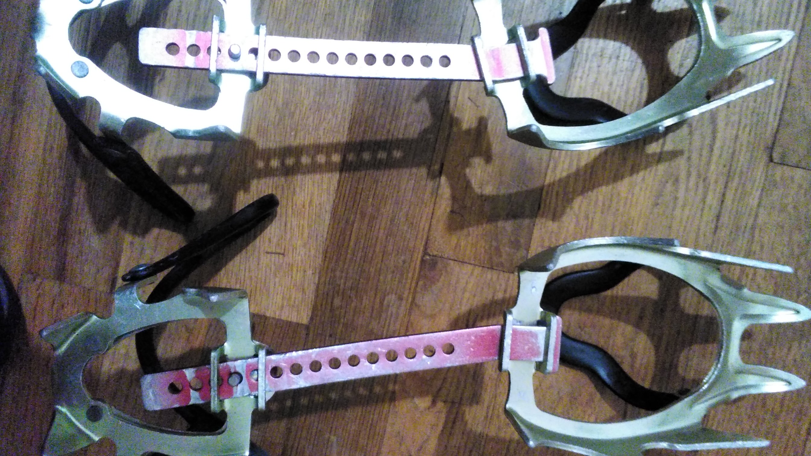
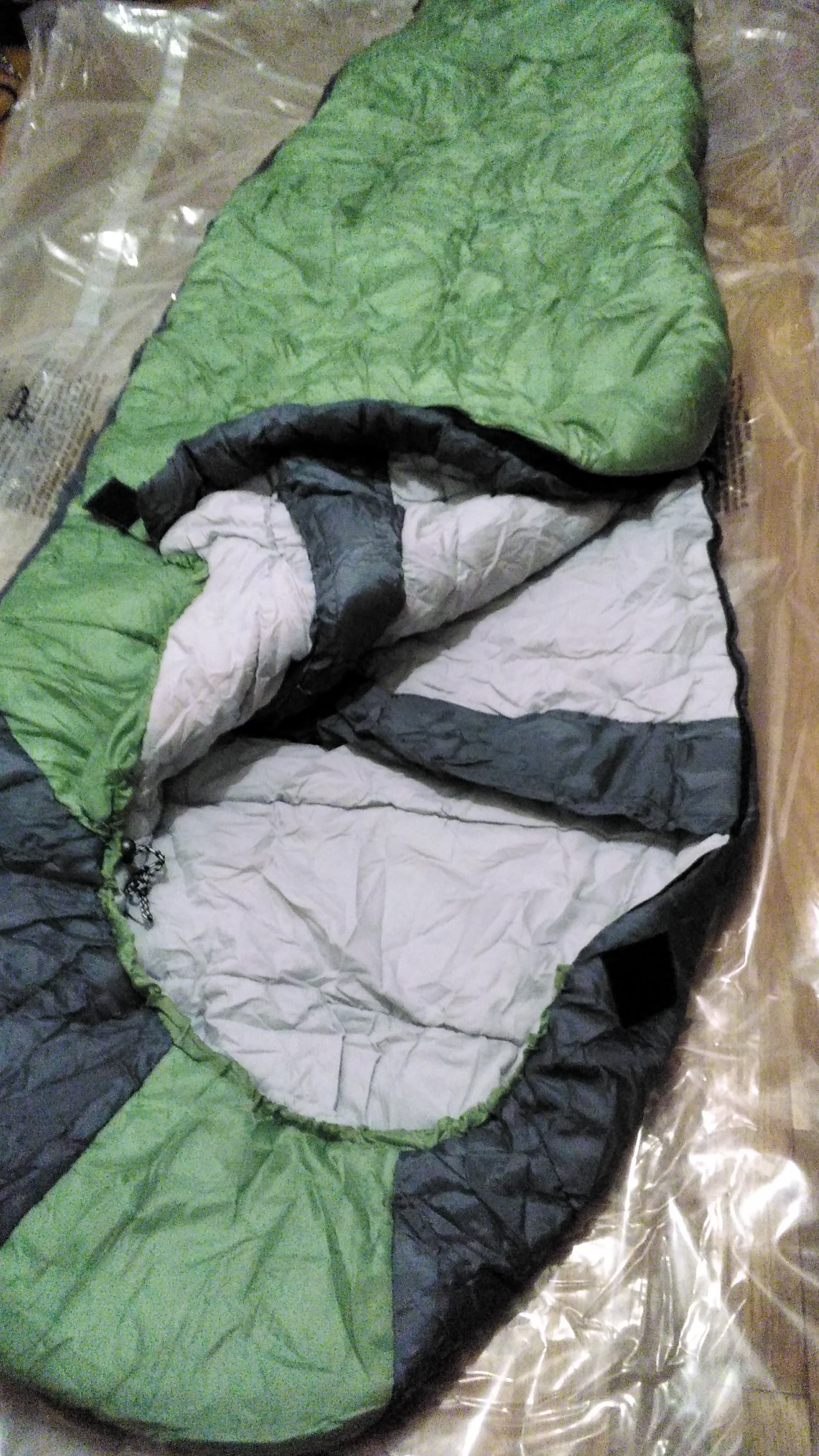
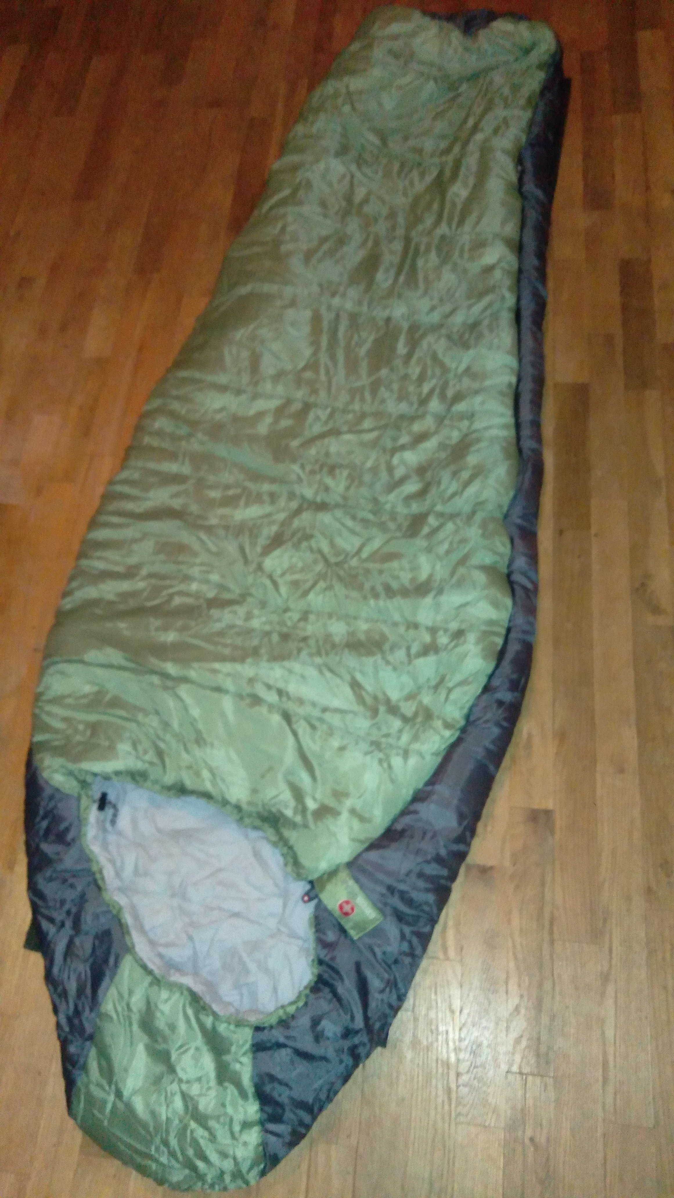
 Decent winter gear if you're on a budget. All gear shown except the shovel is used $80 Used Stubai Tour 52cm aluminum Ice Ax with leash- used on Rainier, Ptarmigan Traverse, cascades etc. More solid than a Camp Corsa but almost as light. $80 Used Mens 10.5 Koflach Degre boots - old REI Rentals. They claim it's "Arctic". Liners intact. Laces intact. No leaks. Very good shape for used plastics $60 Used Camp XLC 490 Aluminum crampons - worn paint but plenty life left on the points. Minimal fraying on straps. Bars were replaced. $40 Used Big Agnes Air Core Ultra 72" air mattress - used a few times. Comfy but not warm enough outside summer. Low R-value. On the plus side it floats. $20 Lifeline Aluminum Shovel (never used) $20 Used Swiss Gear Wenzel Synthetic 0° mummy bag - Warm and cozy. Has baffled zip and neck, and toe-box vent. Only used a couple times in 5 years $20 Used White Sierra packable blue rain jacket medium - water tape intact. Great durable ultra-light rain jacket $20 Used -30°C fleece lined insulated Leather gloves. I never used them but legend has it my brother Josh used these in Alaska. Or buy the whole lot for $300. Just make sure to use a warmer air mattress/foam pad if you decide to make this part of your winter/spring load out kit. I live in the Everett-Seattle area. E-mail me at lewisdmike@gmail.com if you're interested and we'll arrange a public meetup so you can get a better look before deciding if you'll buy. I prefer cash but will accept Venmo.


-
0
-
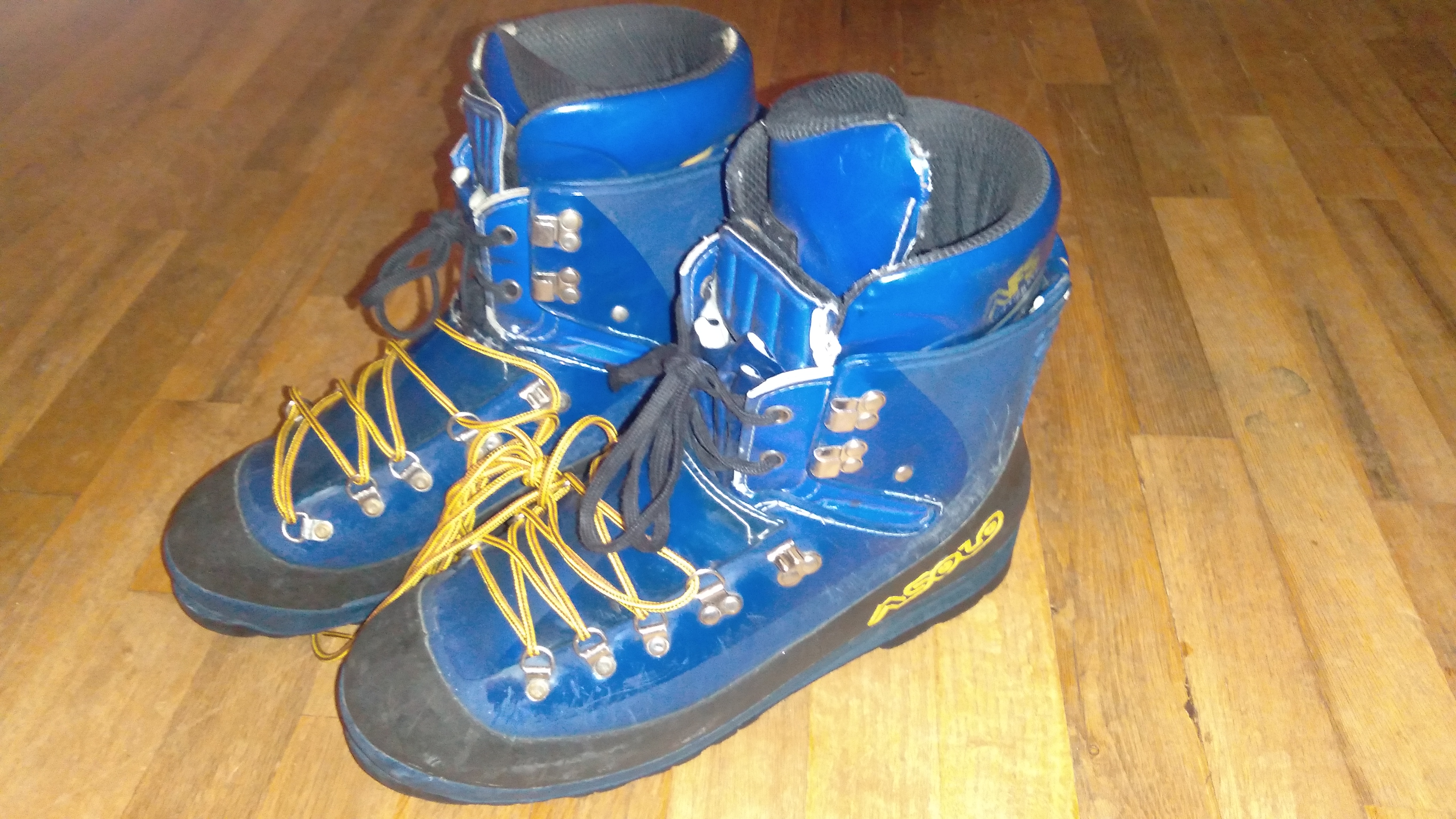
Size 46 Asolo Evoluzone plastic climbing boots $20 Used mainly on glaciers below 6k meters Josh Lewis old boots so they've been around. He's since upgraded. I don't ice climb so can't justify them I'm in the Lynnwood/ Everett area. Message me for time and place.
-
Mostly used gear. The whole lot can go for $200 Camping gear - $100 for bundle: $20 Eureka! Getaway 3900 Backpack with raincover $5 Ridgerest 3/4" full length groundpad $20 Teton Sports 20° Trailhead Bag R (fits up to 5'9") $50 Mountain Hardwear Stiletto 1 Person Tent with Vestible $20 Small Dip down hooded puffy Snow gear - $140 for bundle $80 Camp XLC 490 Crampons (bars are worn) $60 Camp Corsa Ice Ax $20 Old Size 10 Black Scarpa Inverno Plastic Boots $10 Lifeline aluminum shovel Climbing gear - $40 for bundle: $20 Black Diamond Med/Lrg Half Dome Helmet $10 Black Diamond Large Momentum Harness 6 assorted carabiners: 2 locking, 4 regular 6mm prussiks 2 short 1/2" runners $5 Black Diamond ATC-XC belay device $10 CMI pulley I've got bills to pay and I just need to make it to my next paycheck. All this stuff is just sitting in my closet, most likely until June. Pretty sure I'll get new gear when I have a stable income and the call of the mountains is louder. In the mean-time I still have snow shoes so hit me up this winter if y'all are heading somewhere on a weekend.

-
see title
-
Looking for a ride to Tupso Pass 9/24-25 for me and my bike via the canyon creek road. The bridge is still officially "closed" due to structural instability but somebody moved one of the larger boulders out of the way and people have been dog-piling to get to Three Fingers by the dozens. Shamefully, I'm one of them and am willing to pay up to $20 for a 1-way ride. The authorities are going to re-close this road Monday Sept. 26th according to MBSNFS. If you want to hike along that's cool too. P.M. me if you're interested. email works too: lewisdmike@gmail.com http://www.nwhikers.net/forums/viewtopic.php?t=8022311
-
All this stuff is still functional and has seen action from Rainier to Shuksan $20 Urban Outfitters Down Coat 700 fill- Mens Large Navy Blue $20 Kong 12 point strap-on crampons (sharpened twice) $20 70 liter Mountainsmith Pack (used on Alpamayo and Cordillera Blanca) $1 Full length Threshold Gaiters (use string/cord for arch attachment) $5 Arizona Polyester Fleece Pullover - Mens Large Green/White $1 Port Authority Polyester Fleece Vest - Mens Small Black $1 Cotton Bandana - Black $1 Buff - Black
-
Prime!
-
Price lowered to $60
-
Trip: Cashmere Mountain - Lake Victoria/NW Face Date: 4/2/2015 Trip Report: Matt Lemke, Josh Lewis and I went up to Lake Victoria then up snow to the summit following a line on Cashmere's Northwest face using this route. We awoke to cloudy skies that led to a neat sunrise to distract us from the road. [img:lef]http://static.flickr.com/8705/17025444125_83e3afa495_z.jpg[/img] [img:center]http://static.flickr.com/7593/16403019834_e461056de0_z.jpg[/img] [img:center]http://static.flickr.com/8708/16837908670_51d648b68f_z.jpg[/img] [img:center]http://static.flickr.com/7614/16405296243_cc4d11d7e4_z.jpg[/img] [img:left]http://static.flickr.com/7613/16403020504_d0fb682ec4_z.jpg[/img] [img:center]http://static.flickr.com/8689/17024577041_3a389960d0_z.jpg[/img] [img:center]http://static.flickr.com/7644/16837909720_8350c4cef1_z.jpg[/img] The beginning was a sticky bushwhack through 1st gen growth in a burn area. Log jumping and scraping. Log bridges helped but were not enough. Sometimes they had little spears on them. Josh punctured his shoe on one of them and a log tried to kill Matt. Not very enjoyable but very reminiscent of Cannon Mountain on the other side of the creek. [img:left]http://static.flickr.com/8737/16405293853_d5cab52289_z.jpg[/img] [img:center]http://static.flickr.com/7626/16837910010_b11fa4bd6c_z.jpg[/img] [img:center]http://static.flickr.com/7598/17025446135_8fb149272f_z.jpg[/img] [img:center]http://static.flickr.com/8728/16405297653_9b8e07df52_z.jpg[/img] After 5,000' it was all snow. It started out icy thin and punchy over boulders making for sketchy business whenever our path came near a creek. Eventually it became deep and solid. Lake Victoria was still mostly frozen so we walked across to save on our approach time after I displayed my guinea pig powers. Once on the other side, the snow had an icy hard base with a variable 5" crust. Sometimes it was soft, others it was punchy and then others it was ice. The West shoulder of Cashmere blocked out the sun for this part of the climb stabilizing the snow while we climbed a 40 degree gully to the upper basin. [img:left]http://static.flickr.com/7634/16405298093_3de8cb75ed_z.jpg[/img] [img:center]http://static.flickr.com/7622/17024578831_c61fda6145_z.jpg[/img] [img:center]http://static.flickr.com/8684/17023996772_7e3de4740d_z.jpg[/img] [img:center]http://static.flickr.com/7599/16403022664_49d1ac4f10_z.jpg[/img] [img:center]http://static.flickr.com/7604/17024579451_3f35f317ec_z.jpg[/img] [img:center]http://static.flickr.com/7652/16837911980_51d85b56d7_z.jpg[/img] At the upper basin, after much effort kicking steps, we layered up while clouds and wind moved in. We debated whether to follow the standard route from the 8,000' col or just climb straight up one of the many gullies on the Northwest Face that led to the summit. I felt that rime ice would make any scrambling too sketchy so we went up the NW Face, avoiding almost all scrambling save for one move. We summited an hour before sunset with a magnificent show of the entire Enchantments on display. [img:left]http://static.flickr.com/8706/17024581071_4c49303e8e_z.jpg[/img] [img:center]http://static.flickr.com/8751/16837671808_72834ab77a_z.jpg[/img] [img:center]http://static.flickr.com/7589/16837672708_27feb2e633_z.jpg[/img] [img:center]http://static.flickr.com/8695/16837914050_a60eb91120_z.jpg[/img] [img:left]http://static.flickr.com/8734/16839232789_567f7a7177_z.jpg[/img] [img:center]http://static.flickr.com/7611/16839233189_c7399f75ce_z.jpg[/img] [img:center]http://static.flickr.com/8739/16839233739_8d4642bd85_z.jpg[/img] [img:center]http://static.flickr.com/7592/16837907870_139a65119e_z.jpg[/img] [img:center]http://static.flickr.com/7591/16837915860_d18303a778_z.jpg[/img] [img:left]http://static.flickr.com/8703/16405294153_bc8b41d6d4_z.jpg[/img] [img:center]http://static.flickr.com/7653/16999446296_64c9d798ec_z.jpg[/img] [img:center]http://static.flickr.com/8717/16403030384_4f879a6a01_z.jpg[/img] We descended to Lake Caroline at dusk, donned headlamps and looked around for tracks in the snow. Matt led the way using GPS with the full moon shining above the Enchantments while we walked the trail. A symphony of frogs could be heard croaking near the trail head. After another 2.5 mile walk to Bridge Creek, we hitch-hiked back to the car a little dismayed to discover that the management opened the gate while we were up there. All-in-all one of my best ALW summits and incredible view. I only wish there was an established trail to Lake Victoria to avoid the nasty brush. Very decent snow climb that avoids almost all the scrambling and crowds of summer. Thanks Matt for taking us up there and guiding us down in the dark. Gear Notes: Ice-ax,crampons Approach Notes: Bridge creek was closed when we arrived but open when we left. see route link at beginning of report for approach beta
-
Trip: Mount Saint Helens - Worm Flows Date: 3/29/2015 Trip Report: Went up Worm Flows climbing route on Mount Saint Helens with Michael Williamson on March 29th with a snowboard. He provided excellent company and our paces up the mountain were about even. Lots of others on the mountain with skis/snowboards. Conditions were perfect with mostly sunny/high clouds and patchy snow starting at about 5,500' becoming firm at 6,000'. Winds started halfway up and became a steady 40mph making my snowboard a sail which threatened to blow me over. Ice from the crater rim to the true summit made it a little spicy but the run-out was excellent and I was undeterred with an ice-ax. Cornices were very minimal but I still kept a good 15-20 feet clear. Views were pretty good and our route made for a moderately difficult day of about 6,500' of gain. This would be my final Washington Cascade Volcano and I thought I'd try to snowboard down to celebrate. Unfortunately I had forgot how to do it but still managed to laugh at my folly and enjoy the day. Thanks to MW for getting me there. [img:left]http://www.nwhikers.net/forums/thumbs/70/17007530101_d69186a446.jpg[/img] [img:center]http://www.nwhikers.net/forums/thumbs/70/17007532421_840f2bb8d8.jpg[/img] [img:center]http://www.nwhikers.net/forums/thumbs/70/17007532031_f6504f7530.jpg[/img] [img:center]http://www.nwhikers.net/forums/thumbs/68/16801013317_7b6f253637.jpg[/img] [img:left]http://www.nwhikers.net/forums/thumbs/70/17008411935_8254694ac2.jpg[/img] [img:center]http://www.nwhikers.net/forums/thumbs/68/16820665308_1378b3c4d8.jpg[/img] [img:center]http://www.nwhikers.net/forums/thumbs/68/16801012937_32647ddc7b.jpg[/img] [img:center]http://www.nwhikers.net/forums/thumbs/68/16820666988_844e8d56d5.jpg[/img] [img:left]http://www.nwhikers.net/forums/thumbs/63/16386006264_52d663905b.jpg[/img] [img:center]http://www.nwhikers.net/forums/thumbs/68/16820907220_f62ee72874.jpg[/img] [img:right]http://www.nwhikers.net/forums/thumbs/63/16388291433_606d413c40.jpg[/img] Gear Notes: Ice ax, crampons and snowboard Approach Notes: Upper gate was locked so had to start at 2,600'
-
Price lowered to $70
-
Sold: Fischer x-country skis and boots size 40
Mike Lewis replied to Mike Lewis's topic in The Yard Sale
I'm 160 lbs and live in Lynnwood. These were passed down to me so don't really know if I'm in the range they were cambered for. -
Ride from Lynnwood to St. Helens this weekend?
Mike Lewis replied to Mike Lewis's topic in Climbing Partners
I was planning on Saturday and/or Sunday but I don't have transportation as of yet. I found a picture of Mt. St. Helens from last month on nwhikers.net: It would only be about 2k of snow but I still want to try it. Probably an easy day hike in these conditions. NOAA Forecast -
Sold Fischer Double Crown Cross Country Skis 187cm 50mm underfoot with 10mm taper SNS Salomon bindings Fischer x-country boots size 40 (7.5 mens) very light weight
-
Ptarmigan Traverse Partner late April, early May
Mike Lewis replied to tressag's topic in Climbing Partners
With our lower than usual snowpack, that actually sounds really cool. -
Ledge Sports Techlite -20 degree F sleeping bag $60 Product information: http://ledgesports.com/product/techlite-20/ This is a synthetic bag meant for cold temperatures and expedition mountaineering/canyoneering/adventuring. Works when damp even in freezing conditions. I've only used it a couple times. Rated to -20F/-28C but I have only used it down to 0F/-18c in snow in the Cascades so I cannot confirm its comfort rating. Warranty application: http://ledgesports.com/warranty/
-
Hoping to get down there before the reservations start and permits are still free. I was looking forward to snowboarding down while there's still snow. With the low snow-pack this year I speculate the cost of a reservation will not feel worth breathing in all the ash later in summer. Anyone interested feel free to pm, email or call 425 242 8977.
-
Wondering if anyone who's headed North for Cascade Pass area can give me a lift Friday afternoon from Lynnwood Park and Ride. Text 425-791-8998
-
[TR] Mt. Rainier - Gibraltar Ledges / Ingraham Direct 12/14/2014
Mike Lewis replied to Alex Leone's topic in Mount Rainier NP
This is so awesome! You guys were in the spirit! Totally done right. Makes me wish I had skins. Do you think it would be too much trouble without skis (just snowshoes)? -
Partners for Rainier's Liberty Cap in Dec
Mike Lewis replied to Mike Lewis's topic in Climbing Partners
Alright. I've got 4 people interested now. Probably shouldn't add too much more at this point unless we plan to go as two teams of 3. I'd like to start exchanging information to see if we all agree on a plan so send me an email at unsupersmith@gmail.com so we can all be a part of the conversation. -
Hey I'm looking for someone interested in going up Liberty Cap this December if we get any good weather windows. I know it's early winter so I'd put success around 50% but it'd be nice to give it a try. I've been up Rainier once and had a few attempts since then with the most recent being in April. We turned around then because of too much loose snow on our route. I admit, don't know what conditions are right now with limited reports but I expect extreme cold, deep snow and thin snow bridges. I'd like to capitalize on my permit before it expires. A team of 3 or more would be ideal for safe travel. It would be nice to do a z-pulley/snowcave/snowpit refresher as a group before the climb (I know it's lame but I like to be certain we work together). It seems to me that glacier travel is particularly dangerous this time of year. Check Mike Lewis my profile page on SummitPost.org for my history. Send me a pm if you're interested or just reply here for a general discussion. I'm open to suggestions.
-
Trip: Mount Rainier - Disappointment Cleaver Date: 7/13/2010 Trip Report: Team Members: Bill Rogers, Adam Anderson, Josh and Michael Lewis We wanted to summit via the Ingraham Direct route, but Park Rangers and RMI discourage using this route, as large crevasses have begun to form. An aluminum ladder that was spanning a 10' wide crevasse was taken down earlier in the week as the crevasse opened up further causing the ladder to lose purchase. As a result the route was out of season. [img:left; width:100px]http://www.summitpost.org/images/small/639700.jpg[/img] [img:center; width:100px]http://www.summitpost.org/images/small/639685.jpg[/img][img:center; width:100px]http://www.summitpost.org/images/small/639709.jpg[/img][img:right; width:100px]http://www.summitpost.org/images/small/639703.jpg[/img] From Camp Muir (10,080') we went to Ingraham Flats (11,200') to sleep. An unusually wet spring and warm summertime temperatures significantly weakened the rock en route to Ingraham Flats. Wet and thawing layers of tephra loosened layers of rock causing rock-fall throughout the day below Gibralter Rock, Cowlitz Cleaver and Disappointment Cleaver. We tried to avoid these aspects when they were receiving direct sunlight. The beginning of the route is very strait-forward. There are a couple fixed lines by RMI to help clients deal with the rock exposure on the Disappointment Cleaver at the start. Once on top the cleaver, at about 12,270', the climber's boot path meanders over to the Ingraham glacier as it connects with the Emmons to form the summit ice cap. There are several crevasses that must be crossed or bypassed. Only a couple of them were particularly impressive. Some were beginning to merge right on the climber's trail, especially around 13,000' so we took care to avoid possibly collapsing snow-bridges. The path accessed the crater rim from the SSE. [img:left; width:150px]http://www.summitpost.org/images/medium/639704.jpg[/img] [img:right; width:150px]http://www.summitpost.org/images/medium/639707.jpg[/img] Once on the summit crater, there was an obvious boot-path that went to the North of the USGS marker. You must search the summit crater for the Register as it is not at the highest point, but under a large rock along the rim. I could not find it. We descended via the same route, making slight adjustments as conditions changed (navigating opening crevasses, avoiding extremely wet snow or rock-fall). I'm glad to have made this life-long goal after a year of training with friends gimpilator, colin woods and Eastking. Gear Notes: ice axes, crampons, harnesses, 60m dryrope, prussics, snow anchors and slings Approach Notes: Good weather but forecast for a windy day by day 3 so we made it a quick 2 days instead. Snow was excellent.
-
4-ML-97742-ML- Moved to Rainier forum